Master Drone Surveying and Mapping: Essential Tips & Techniques
- Nickolas Williams

- Jun 8, 2025
- 14 min read
Updated: Jun 11, 2025
Understanding The Drone Surveying Revolution
Imagine trying to map a 500-acre construction site the old-fashioned way, with boots on the ground. You'd need weeks, a whole team, and face real safety risks. Now picture getting that same data in just a couple of hours, accurate down to the centimeter. That's the power of drone surveying and mapping. It's changing how industries work all over the world.
These high-tech flying platforms combine the pinpoint accuracy of GPS with advanced sensors to create incredibly detailed maps and surveys. Drones are dramatically changing how land surveying is done; you can learn more in this article: Drone Operations Transforming Land Surveying. This technology isn't just faster; it opens doors to things we simply couldn't do before.
Core Technologies Behind The Revolution
This shift is happening thanks to a few key technologies working together. First, highly accurate GPS systems tell us exactly where the drone is in the air. This location data is essential for tying the collected information to real-world coordinates. Then, Inertial Measurement Units (IMUs) track the drone's orientation and movement, making the data even more accurate.
Advanced sensors are also vital for capturing detailed information. Photogrammetry takes thousands of overlapping aerial photos and stitches them together into precise 3D models. Think of it like assembling a jigsaw puzzle, where each piece is a high-resolution image from the sky. LiDAR sensors, on the other hand, use laser pulses to see through vegetation, revealing the ground below, even if it's hidden.
This combination of precise positioning and powerful sensors lets drones collect millions of data points – the kind of data that would take traditional methods months to gather. This speed and efficiency saves a lot of money and opens up whole new ways of thinking about surveying and mapping. For example, the drone surveying market is booming. It's projected to reach $1.97 billion by 2025 and then explode to $11.49 billion by 2035, growing at a 19.3% Compound Annual Growth Rate (CAGR). Several things are driving this growth, including the increasing need for efficient and affordable surveying across industries like construction, infrastructure, and agriculture. Discover more insights. This rapid growth shows the real benefits and return on investment that drone surveying offers across many different sectors. From construction sites to farm fields, drones are becoming essential tools for getting accurate and timely data.
How Drones Transform Raw Images Into Actionable Data
Think of a drone used for surveying and mapping as a high-tech camera in the sky. It's not just snapping photos; it’s meticulously collecting data that can be translated into useful information for a wide range of applications. This transformation, from raw image to practical insight, involves a fascinating interplay of cutting-edge technology and powerful processing.
From Pixels To Points: The Role of Sensors
Drones used in surveying and mapping employ an array of sensors, each designed to capture specific types of data. RGB cameras, much like the camera in your smartphone, capture the visible light spectrum. This data provides the rich visual detail needed for creating accurate maps and 3D models.
But what about information we can't see with the naked eye? That’s where multispectral sensors come in. These specialized sensors detect light beyond the visible spectrum, revealing details about vegetation health or soil moisture content. Imagine a farmer using this data to pinpoint areas of a field needing attention, potentially saving a significant portion of their crops.
Then there are thermal cameras. These sensors detect heat signatures, making them incredibly useful for applications like roofing inspections, where they can identify insulation problems, or even wildlife monitoring, allowing researchers to track animals in challenging conditions.
Stitching It Together: Photogrammetry and Data Processing
So, how do we go from thousands of individual images, captured from a drone in flight, to a seamless map or model? This is where the magic of photogrammetry happens. Photogrammetry uses the overlap between images to construct 3D representations. Think of it like taking a series of pictures of an object from slightly different angles. Photogrammetry software analyzes these images, identifies common points, and uses this information to rebuild the object's 3D shape.
This same principle is applied to create orthomosaic maps, which are essentially geometrically corrected aerial images, and digital elevation models (DEMs), which provide a 3D representation of the terrain. The increasing demand for this technology is reflected in the projected growth of the global drone market, including surveying and mapping, estimated to reach $57.8 billion by 2030 (Learn more about drone market trends). The commercial drone sector is anticipated to see a 7.9% Compound Annual Growth Rate (CAGR), with the drone analytics market expected to hit $26.7 billion by 2030.
The AI Advantage: Automating Insights
The power of artificial intelligence (AI) and machine learning (ML) is revolutionizing the field of drone surveying and mapping. These technologies automate time-consuming tasks that previously required extensive manual effort. AI can automatically identify features within images, like buildings, roads, or vegetation. This significantly speeds up data analysis and allows us to extract more valuable information from the collected data.
Imagine trying to manually calculate the volume of a material stockpile at a construction site – a tedious and error-prone process. With AI, this is done automatically, providing quick and precise measurements vital for project management.
Furthermore, ML algorithms are making the complex world of surveying more accessible. You no longer need years of experience in photogrammetry to create professional-quality maps and models. These advancements are democratizing powerful tools that were once only available to specialized experts. These automated processes not only save time and resources but also dramatically improve the accuracy and reliability of the data. By reducing manual intervention, AI minimizes the risk of human error, ensuring higher-quality results. And the evolution of AI continues, promising even more powerful and efficient solutions for the future of drone surveying and mapping.
Choosing The Right Software For Your Mapping Needs
Imagine having all the ingredients for a delicious cake, but no oven or recipe. That’s what it’s like having thousands of drone images without the right software to process them. They're just raw data, full of potential but unusable. This section will help you navigate the world of drone mapping software and find the perfect platform for your needs.
Think of the software as your oven and recipe book, transforming raw aerial photos into valuable maps and 3D models. Just as different ovens have different features, drone mapping software varies in its capabilities and complexity.
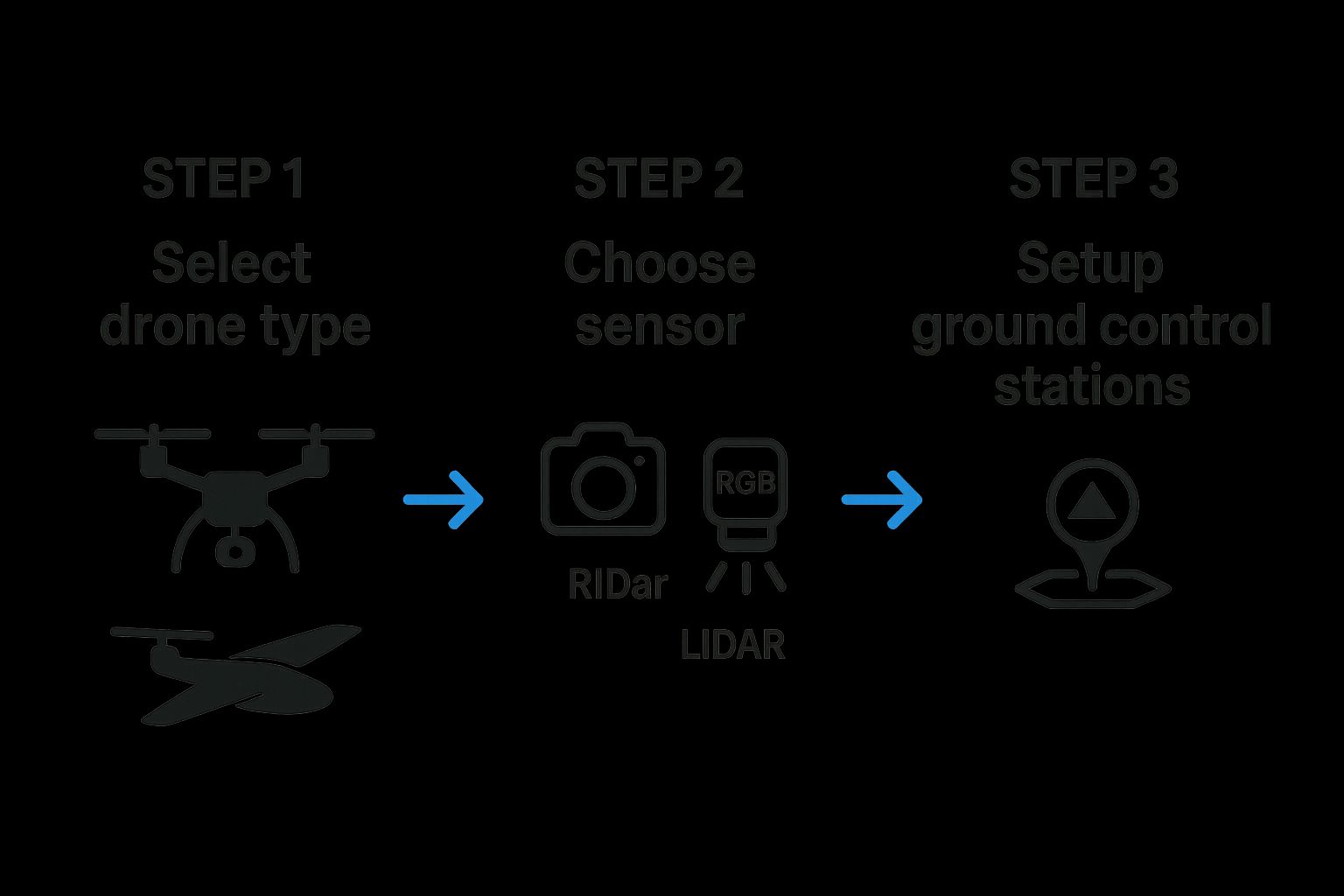
This infographic illustrates the planning stages of a drone survey. Notice how interconnected each step is. Choosing a fixed-wing drone versus a multirotor affects sensor options and ground control setup. Grasping these dependencies is key for successful drone mapping projects. For a deeper dive into flight planning, check out this guide on top software for UAV control and flight planning in 2025.
Navigating The Software Landscape
Drone mapping software ranges from easy-to-use cloud platforms to powerful desktop applications. Cloud-based solutions like DroneDeploy are often a good starting point for beginners. They handle most of the processing remotely, simplifying the workflow and minimizing the need for advanced technical skills. When working with large image files, understanding file compression can be beneficial. This article on the science behind file compression offers helpful insights.
For more complex projects, desktop applications like Pix4D provide more control and advanced features. Think of them as professional-grade ovens, offering precise control over every setting. They allow experienced users to fine-tune parameters and extract maximum detail from their data. For research-grade accuracy, Agisoft Metashape is a popular choice, known for its precision in demanding applications.
Key Features To Consider
When selecting software, consider your specific needs. Some platforms excel at creating orthomosaic maps (like a high-resolution aerial photograph), while others specialize in detailed 3D models or digital elevation models (DEMs) which capture terrain elevation. Here's a quick checklist:
Data Import and Compatibility: Make sure the software works with your drone's sensor formats.
Processing Capabilities: Can it handle the size of your datasets and produce the outputs you need?
Quality Control Tools: Does it offer tools to verify data accuracy?
Reporting and Export Options: How will you share your finished products?
To help you compare some popular options, take a look at the table below:
Popular Drone Mapping Software Comparison
This table compares leading drone mapping software platforms, highlighting their key features, pricing models, and ideal use cases. It’s a quick way to see how different options stack up against each other.
Software | Processing Type | Key Features | Best For | Pricing Model |
|---|---|---|---|---|
Cloud | Automated processing, easy-to-use interface, collaboration tools | Beginners, small to medium projects | Subscription | |
Desktop/Cloud | Advanced processing, robust feature set, precise control | Large projects, experienced users | Subscription/Perpetual | |
Desktop | Research-grade accuracy, detailed 3D modeling, versatile outputs | Scientific applications, high-precision mapping | Perpetual |
As you can see, each software has its strengths. DroneDeploy is great for getting started, Pix4D offers more control for advanced users, and Agisoft Metashape delivers the highest level of accuracy.
Beyond The License: Hidden Costs
Remember, the price tag isn't the whole story. Factor in hardware requirements. Some desktop applications need powerful computers. Training time is another hidden cost. User-friendly platforms require less training, while others demand more time investment. Finally, consider the level of ongoing support offered by the vendor. Access to documentation and technical help can be invaluable.
By carefully considering these factors, you can select the right drone mapping software to unlock the potential of your aerial data. Understanding your project needs, the software's capabilities, and the associated costs will help you transform raw images into valuable, actionable insights.
Real Projects That Changed How Industries Work
Let's shift gears from theory to practice. Let's explore how drone surveying and mapping is changing industries worldwide. Picture this: a construction manager tracking excavation progress live, calculating material volumes with incredible accuracy. This isn't science fiction; it's happening now, thanks to drones. This real-time data allows for precise calculations, avoiding costly overruns and keeping projects on track.
Agriculture: Saving Crops Before Problems Appear
Imagine a specialist in precision agriculture. They're using multispectral imaging to spot crop diseases weeks before they're visible to the naked eye. Early intervention can save entire harvests, protecting livelihoods and food security. This proactive approach minimizes loss and maximizes yield, showing the real benefits of drone technology in agriculture. Interested in learning more? Check out this article: Top Drone Applications in Agriculture for Better Farming. This targeted approach to crop management also optimizes resource use and minimizes environmental impact.
Infrastructure: Safe Inspections, Lower Risks
Think about inspecting the underside of a bridge or a tall transmission tower. These are traditionally dangerous and expensive tasks, often requiring scaffolding and specialized crews. Drones offer a safer, more efficient way, capturing detailed images and data without putting workers in harm's way. This not only saves money but, more importantly, saves lives. By removing the need for complex and expensive access methods, drones drastically cut the overall cost of infrastructure inspections. The detailed data collected by drones also allows for more accurate assessments of structural integrity, leading to more informed maintenance decisions.
Emergency Response: Critical, Life-Saving Tools
In emergencies, every second is precious. Drones with thermal cameras can quickly find missing people in search and rescue operations, providing crucial information to first responders. This can be the difference between life and death, highlighting the invaluable role of drones in emergencies. The quick deployment and bird's-eye view of drones provide a vital edge in time-sensitive search and rescue missions. The ability to cover large areas quickly significantly increases the chances of a successful outcome.
Environmental Monitoring: Protecting Our World
Environmental scientists use drones to monitor erosion patterns, gathering data that informs important conservation decisions. This information helps protect fragile ecosystems and lessen the impact of climate change. The precise data from drones allows scientists to track changes over time, giving valuable insight into environmental processes. This detailed monitoring helps pinpoint at-risk areas and put effective conservation measures into place.
Mining and Renewables: Increasing Efficiency and Profits
Drone surveying and mapping is transforming industries like mining and renewable energy. Mining operations use drones to calculate stockpile volumes precisely, directly impacting financial reporting. This accurate data improves inventory management and resource allocation. Drone mapping is a critical area benefiting from advancements in drone technology. The global drone mapping market is projected to reach $1.3 billion by 2025 and grow at a CAGR of 17.1%, reaching $6.7 billion by 2035. The construction sector is predicted to be the most profitable area for drone mapping, with a CAGR of 20.2% from 2025 to 2035 (Explore the full research). Renewable energy companies use drones to inspect wind turbines at a fraction of the traditional cost, improving the accuracy of maintenance schedules. These applications highlight the versatility and cost-effectiveness of drone technology across diverse industries. By streamlining inspections and providing accurate data, drones optimize maintenance schedules, minimizing downtime and maximizing energy output. These advancements lead to substantial cost savings and better operational efficiency.
Planning Surveys That Deliver Professional Results
Imagine you're leading an orchestra. You've got talented musicians and incredible instruments, but without a score, a conductor, and a well-rehearsed plan, the music would be chaotic. Drone surveying is much the same. The most advanced drone won’t guarantee success. It’s the planning that truly delivers professional results.
Site Assessment: Knowing Your Battlefield
Before any mission, a good general scouts the terrain. Similarly, experienced drone surveyors don't just launch their drones; they study the site. They carefully consider the complexity of the terrain, how dense the vegetation is, and potential obstacles – things like power lines or radio towers that could interfere with the drone’s signal. This pre-flight checkup helps ensure smooth data collection and prevents costly surprises down the line. Think about a heavily forested area. You might need to fly lower or use LiDAR to see through the canopy. That affects battery life and your entire flight plan.
Flight Planning: The Art and Science of Data Acquisition
Flight planning is the core of drone surveying. This is where you decide how high the drone should fly (flight altitude), how much each image should overlap the next (image overlap percentage), and where to place ground control points (GCPs), which are precisely measured points on the ground that act like anchors for your data. These elements are interconnected and essential for accurate results. It's like building a house – a strong foundation (flight plan) is crucial for a stable structure (accurate data). Want more tips on achieving accurate aerial surveys? Check out our guide: Drone 3D Mapping Tips for Accurate Aerial Surveys.
Timing Is Everything: Environmental Considerations
Just like a photographer waits for the perfect light, a drone surveyor needs to consider environmental factors. Weather, lighting, and even the time of year can dramatically impact the quality of your data. Strong winds can make flying dangerous, while overcast skies offer more consistent lighting than a bright sunny day. Understanding these nuances and adjusting your approach is a key difference between a novice and a seasoned professional.
Advanced Techniques: Corridor Mapping and Cross-Sectional Analysis
For linear infrastructure projects – think pipelines, roads, or power lines – corridor mapping is a game-changer. The drone flies along the corridor, collecting a detailed strip of data. This allows for precise measurements and analysis of the surrounding area. Another useful technique is cross-sectional analysis, which is often used for things like calculating earthwork volumes. Imagine slicing through a 3D model to get precise measurements. These techniques provide valuable data beyond basic mapping.
Managing Expectations and Maintaining Quality
Open communication with clients is just as important as the technical side of things. It's vital to clearly explain what's achievable and any potential limitations. Equipment can fail, so having backup plans is essential. Consistent quality, regardless of the project or environmental conditions, is a sign of a true professional. Just like a skilled craftsperson takes pride in their work, a drone surveyor should always strive for accuracy and precision. This dedication builds trust with clients and leads to better outcomes.
To illustrate the different accuracy needs across various industries, let's look at the following table:
Drone Survey Accuracy Requirements By Industry
Standards and accuracy requirements for drone surveying across different industry applications
Industry | Typical Accuracy Required | GCP Density | Flight Height | Overlap Percentage |
|---|---|---|---|---|
Construction | 1-3 cm | High | Low to Moderate | 80-90% |
Agriculture | 5-10 cm | Moderate | Moderate to High | 70-80% |
Mining | 10-20 cm | Low to Moderate | High | 60-70% |
Archaeology | 1-5 cm | High | Low | 85-95% |
As the table shows, industries like construction and archaeology demand higher accuracy and therefore necessitate a denser network of GCPs, lower flight altitudes, and higher image overlap. Conversely, industries like mining can often tolerate lower accuracy. Choosing the right parameters for your specific project is crucial for obtaining useful and cost-effective results.
Navigating Real-World Challenges and Limitations
Even the best-laid plans can go astray. Drone surveying and mapping, despite meticulous preparation, faces its share of real-world obstacles. Think of it like a meticulously planned hiking trip – you've got your route mapped out, gear checked, but you still might encounter unexpected storms or a twisted ankle. This section explores these potential "hiccups" and how to overcome them. You might find these Drone safety tips: how to avoid accidents and hazards helpful, too.
Weather Dependence: The Unpredictable Factor
Probably the biggest challenge in drone operations is the weather. Imagine a critical project with a tight deadline, only to be grounded by a sudden downpour or strong winds. These delays can significantly impact budgets and timelines. Experienced drone operators understand that flexibility and backup plans are key. Sometimes, the best approach is simply waiting a few hours, or even a day, for better conditions. This highlights the importance of incorporating buffer time into project schedules.
Regulatory Restrictions: Knowing the Rules of the Air
Drone regulations are a constantly evolving landscape, varying considerably by location and the specific application. Flying near airports or sensitive areas often requires special permits, adding complexity to operations. Staying informed about these changing rules is crucial for safe and legal flights. Ignoring these regulations is not an option, as the penalties can be quite steep. This reinforces the importance of thorough pre-flight research and adherence to all local rules.
Battery Life: The Endurance Challenge
Battery life presents a significant constraint, especially for large-scale surveys. Picture this: you're mapping a vast area, and your drone's battery dies mid-flight. Not ideal. Multiple battery swaps are often necessary, but each swap carries the risk of disrupting data collection. Careful flight planning and efficient battery management are crucial. This often involves pre-determining safe and accessible landing spots for quick battery changes.
Equipment Failures: Expect the Unexpected
Like any technology, drones can malfunction. A sudden camera glitch, a sensor failure, or even a software crash could compromise an entire mission. Experienced professionals always carry backup equipment and have contingency plans in place. This redundancy helps minimize downtime and can often salvage projects facing unexpected technical difficulties. Regular drone maintenance and thorough pre-flight checks are also essential for minimizing such risks.
Accuracy Misconceptions: Setting Realistic Expectations
Setting realistic expectations with clients is paramount. While drone surveying and mapping offers high accuracy, it's not flawless. Factors like the placement of Ground Control Points (GCPs), sensor calibration, and data processing techniques all play a role in the final accuracy. Overpromising can lead to disappointed clients and damage professional relationships. Honest and upfront communication about limitations and potential sources of error is the foundation of successful projects.
Emerging Solutions: Overcoming Limitations
The good news is that the drone industry is constantly evolving. We're seeing improved battery technologies that extend flight times, enhanced processing algorithms that can handle less-than-perfect data, and streamlined regulatory processes that help make drone operations more predictable. These advancements are continually pushing the boundaries of what's possible with drone surveying and mapping, paving the way for more efficient and reliable data acquisition in the future.
Your Path Forward In The Drone Surveying World
So, you're curious about drone surveying? Whether you're a seasoned surveyor looking to add drones to your toolkit or just starting out, understanding the path to success is key. Think of this like planning a road trip – you need a map, the right vehicle, and some idea of where you’re going. This section provides practical guidance to get you started.
Getting Started: Training and Certification
Just like getting your driver’s license, drone surveying requires proper training. The level you need depends on your goals. For basic operation, online courses and hands-on flight practice are a good starting point. Think of it as learning the rules of the road. For professional work, consider certification programs covering topics like photogrammetry, data processing, and regulatory compliance. These certifications are like getting a commercial driver’s license – they show you’re serious and competent.
Equipment Investments: Balancing Cost and Performance
Choosing the right drone is like picking the right car for the job. You don’t need a top-of-the-line model to get started. Entry-level drones can handle basic mapping projects surprisingly well. As you gain experience and take on more complex work, you can upgrade to more advanced platforms with specialized sensors like LiDAR. It’s like adding tools to your toolbox – start with the essentials and build from there.
Learning From the Pros: Mistakes and Breakthroughs
One of the best ways to learn is from others’ experiences. Connect with experienced drone surveyors. Hear about their mistakes, their “aha!” moments, and the advice they wish they’d had starting out. It’s like having a seasoned traveler share tips and shortcuts – it can save you time and headaches.
Bridging the Gap: Traditional Surveying vs. Drone Surveying
If you come from a traditional surveying background, certain skills will translate directly, like understanding coordinate systems and mapping principles. But drone surveying brings new concepts – flight planning, data processing, and yes, that photogrammetry again. It's like adding a new dialect to your language skills. You have the base, but there are new nuances to learn.
Building Expertise: Practice, Mentorship, and Continuous Learning
Practice makes perfect, right? The more you fly and process data, the more comfortable and skilled you'll become. Finding mentors can fast-track your learning and open doors to valuable networking opportunities. And since the drone world is constantly evolving, staying up-to-date with new tech and regulations is crucial. Think of it as keeping your skills sharp and your knowledge current.
Your Timeline to Success: Realistic Expectations
Building a successful drone surveying business takes time. Don’t expect to become a pro overnight. Set realistic goals for skill development and finding clients. It's a marathon, not a sprint. Focus on building a strong foundation. Patience and persistence will pay off.
Ready to take off? Explore more of the drone world at JAB Drone.
Comments