Top Drone Applications in Agriculture for Better Farming
- Paul Simmons

- Jun 3, 2025
- 23 min read
Taking Farming to New Heights
Want to discover how drones are transforming agriculture? This listicle explores 8 key drone applications in agriculture, demonstrating how this technology improves efficiency and sustainability. Whether you're a drone hobbyist, pilot, or photographer, discover how drones contribute to everything from crop health monitoring and precision spraying to livestock management and yield estimation. Learn how drone technology, from companies like JAB Drone and others, empowers farmers to better manage resources and grow food. Read on to explore these impactful applications.
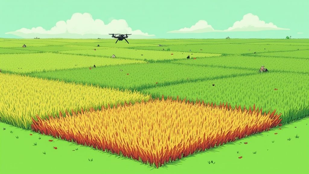
1. Crop Health Monitoring and Disease Detection
One of the most transformative drone applications in agriculture is crop health monitoring and disease detection. This innovative approach leverages drones equipped with advanced imaging technologies, like multispectral and thermal cameras, to provide farmers with an unprecedented level of insight into the well-being of their crops. These drones capture high-resolution imagery that goes beyond what the naked eye can see, revealing subtle variations in plant health, identifying early signs of disease, nutrient deficiencies, and pest infestations before they become widespread problems. This early detection empowers farmers to take swift, targeted action, minimizing crop losses and optimizing resource utilization.
The core of this technology lies in the ability of multispectral cameras to capture data from different wavelengths of light, including near-infrared and red-edge, which are particularly sensitive to plant health. This data is then processed using specialized software to generate vegetation indices, such as the Normalized Difference Vegetation Index (NDVI). NDVI provides a quantitative measure of plant health, highlighting areas of stress or disease. Furthermore, AI-powered disease identification algorithms can analyze the captured imagery to pinpoint specific diseases and pests, providing even more precise information to guide treatment strategies. This real-time data processing and mapping capability, often integrated with farm management software, allows farmers to make informed decisions quickly and efficiently.
Several companies have pioneered the use of drones for crop health monitoring. John Deere's partnership with Taranis, for example, showcases the potential of automated crop scouting and early problem detection. DJI Agriculture's P4 Multispectral drone has been widely adopted by corn farmers in Iowa, helping them optimize fertilization and irrigation practices. Sentera's FieldAgent platform offers another powerful solution, currently deployed across 10 million acres in North America, providing valuable insights to growers across a wide range of crops. These examples demonstrate the practical application and widespread adoption of this technology, solidifying its position as a crucial tool in modern agriculture. Learn more about Crop Health Monitoring and Disease Detection
This approach offers significant advantages over traditional methods of crop scouting. Early detection of problems prevents widespread crop losses, reducing the financial impact of diseases and infestations. Targeted application of pesticides and fertilizers, guided by drone imagery, minimizes chemical usage, promoting sustainable farming practices and protecting the environment. Drones also cover vast areas quickly and efficiently, making large-scale crop monitoring feasible and cost-effective compared to manual scouting. Moreover, the collected data provides valuable historical records, enabling farmers to analyze trends, optimize crop management strategies, and improve yields over time.
While the benefits are numerous, there are some considerations to keep in mind. The initial investment in drone equipment can be significant. Interpreting the data effectively requires some technical expertise, although user-friendly software is increasingly making this process more accessible. Drone operations are also weather-dependent, and limited battery life can restrict flight time.
For those interested in using drones for crop health monitoring, a few practical tips can help ensure successful implementation:
Optimal Lighting Conditions: Fly your drone during periods of optimal lighting, typically 2 hours after sunrise or before sunset, to minimize shadows and maximize image quality.
Consistent Flight Altitude: Maintain a consistent flight altitude throughout your missions to ensure accurate data comparison and analysis.
Sensor Calibration: Regularly calibrate your sensors to ensure precise measurements and reliable data.
Flight Planning: Create flight plans with 70-80% image overlap to ensure complete coverage and accurate stitching of images.
This combination of advanced imaging technology, sophisticated data analysis, and practical application makes crop health monitoring and disease detection one of the most compelling drone applications in agriculture, contributing to increased efficiency, sustainability, and profitability in farming operations. Companies like DJI Agriculture, Sentera, Taranis, and PrecisionHawk have played a key role in popularizing and advancing this technology, making it increasingly accessible to farmers worldwide.
2. Precision Spraying and Chemical Application
Precision spraying and chemical application is revolutionizing modern agriculture, offering a targeted approach to crop protection and nutrient management. This drone application in agriculture involves equipping drones with specialized spray systems to deliver pesticides, herbicides, and fertilizers with pinpoint accuracy. Utilizing GPS guidance and variable rate technology, these systems analyze real-time data to apply chemicals only where needed, minimizing waste and environmental impact while optimizing crop protection efficiency. This targeted application contrasts sharply with traditional blanket spraying methods, making it a significant advancement in sustainable farming practices. This method deserves its place on this list due to its potential to significantly increase efficiency and reduce the environmental footprint of agriculture.
One of the core features enabling this precision is variable rate application technology. This allows farmers to adjust the amount of chemical applied based on the specific needs of different areas within a field. Combined with GPS-guided precision navigation, drones can follow pre-programmed flight paths, ensuring consistent and uniform coverage. Adjustable nozzle systems further refine the application process, allowing for control over droplet size and spray pattern. Real-time flow rate monitoring ensures accurate dispensing, and obstacle avoidance sensors enable safe navigation around trees, power lines, and other obstacles. Tank capacities typically range from 5-40 liters, catering to diverse field sizes and application requirements.
The benefits of drone spraying are numerous. It can achieve a staggering 90% reduction in chemical usage compared to traditional methods, significantly minimizing environmental contamination and promoting sustainable agriculture. Drones also provide access to difficult terrain and waterlogged fields, areas often inaccessible to conventional ground-based equipment. Application speed is dramatically faster compared to manual spraying, allowing for timely treatment of crops during critical growth stages. Further advantages include reduced soil compaction, lower labor costs, and minimized safety risks associated with manual chemical handling.
However, there are some limitations to consider. The limited payload capacity of drones necessitates frequent refilling, potentially impacting overall efficiency in large-scale operations. Wind conditions can also affect spray accuracy, requiring careful planning and execution. The upfront costs of acquiring drone spraying equipment are generally higher than manual spraying methods, presenting a barrier to entry for some farmers. Finally, regulatory restrictions surrounding drone operations and chemical application vary across regions, requiring careful adherence to local laws.
Successful implementations of drone spraying are already evident worldwide. The XAG P100 Pro is being used for rice field spraying in China, covering over 100 hectares daily. In Brazil, custom applicators are deploying the DJI Agras T40 in soybean fields, demonstrating its effectiveness in large-scale operations. Yamaha's RMAX helicopter has been a mainstay in crop dusting in Japan for over 30 years, showcasing the longevity and proven effectiveness of aerial application methods.
The following infographic visualizes key data points highlighting the efficiency and operational considerations of precision spraying:
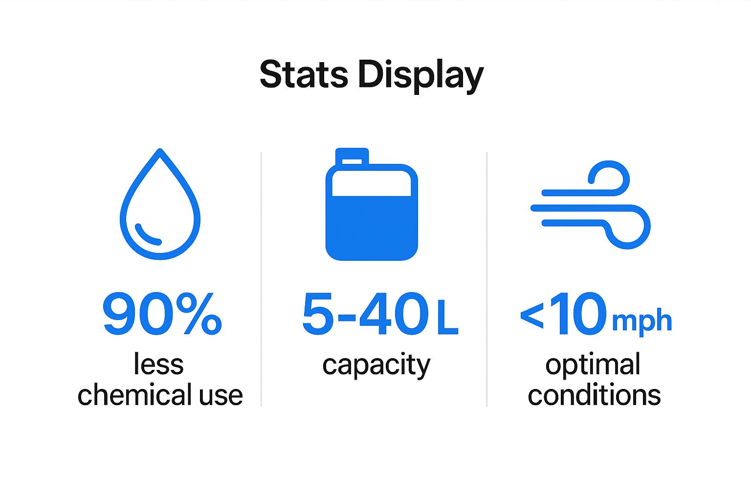
The infographic emphasizes the substantial 90% reduction in chemical use, the variable tank capacities catering to different needs (5-40L), and the importance of optimal wind conditions (<10 mph) for effective spraying. These numbers highlight the potential for both environmental and operational benefits.
For optimal results, it's crucial to follow some best practices. Spray during calm weather conditions (wind speed <10 mph) to minimize drift. Utilize drift-reducing nozzles and adjuvants to further enhance accuracy and minimize off-target application. Maintain a proper flight height (1-3 meters above the crop canopy) for even coverage. Always adhere to local regulations for chemical application and perform regular maintenance of spray systems to prevent clogging.
Companies like DJI Agriculture, XAG, Yamaha Motor, and PrecisionHawk have been instrumental in popularizing and advancing drone spraying technology. Learn more about Precision Spraying and Chemical Application to understand the cost implications and other key factors. This drone application in agriculture represents a significant step towards a more sustainable and efficient future for farming.
3. Livestock Monitoring and Management
The vast expanses of farmland and ranchland present unique challenges for livestock management. Traditional methods of monitoring herds can be time-consuming, labor-intensive, and often ineffective, especially in remote or difficult-to-access areas. This is where drone technology offers a transformative solution. Drones equipped with advanced imaging systems and intelligent software are revolutionizing livestock monitoring and management, offering a bird's-eye view of the herd and providing invaluable data for informed decision-making. This application of drone technology in agriculture significantly improves efficiency, reduces costs, and enhances animal welfare.
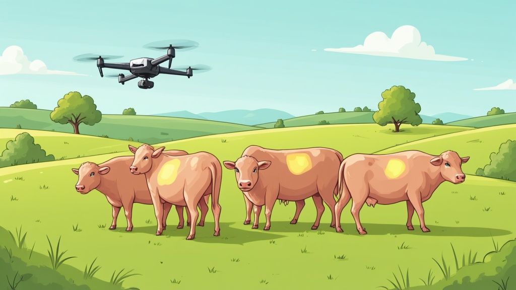
Drones offer a powerful combination of aerial surveillance and data analysis capabilities for livestock management. High-resolution cameras capture detailed images and videos of the herd, allowing farmers and ranchers to visually inspect animals for signs of illness, injury, or distress. This visual inspection is significantly enhanced by thermal imaging cameras, which detect variations in body temperature. A slight rise in temperature can be an early indicator of sickness, allowing for prompt intervention and potentially preventing the spread of disease throughout the herd. This early detection is crucial for minimizing losses and ensuring the overall health and well-being of the livestock.
Beyond visual inspection, drones equipped with AI-powered software can automate tasks like animal counting and identification. This eliminates the need for manual counting, which is often inaccurate and time-consuming, particularly with large herds. The AI can also be trained to recognize individual animals based on unique markings or features, enabling precise tracking of individual animal health and movement patterns over time. Integrating real-time GPS tracking into the drone system allows for precise location monitoring of the entire herd, simplifying tasks like mustering and locating stray animals. Long-range communication capabilities ensure that data is transmitted quickly and efficiently, even in remote areas. Furthermore, night vision and low-light operation capabilities extend the monitoring window, providing valuable insights into animal behavior and security even after sunset. Automated flight pattern programming allows for consistent and repeatable data collection, making it easier to track changes over time.
The benefits of drone-based livestock monitoring are numerous. Covering vast grazing areas quickly, drones can inspect large herds in a fraction of the time it would take using traditional methods. This rapid assessment enables early detection of sick animals, reducing herd losses due to disease or injury. Compared to helicopter monitoring, drones are significantly less expensive to operate and minimize stress on livestock due to their quieter operation and smaller size. Accurate population counts provided by drones improve inventory management, and the aerial surveillance enhances ranch security against predators and theft.
Examples of successful implementation are plentiful. Australian cattle ranchers utilize drones like the DJI Mavic 2 Enterprise Advanced for mustering operations, effectively herding cattle across vast properties. In Patagonia, sheep farmers employ FLIR thermal drones to monitor flocks for signs of illness and predation. Texas ranches use the Parrot ANAFI USA for predator detection and overall livestock security, adding another layer of protection to their operations.
While the advantages are significant, there are also some considerations when implementing drone-based livestock monitoring. Animals may be initially disturbed by the presence of a drone. To mitigate this, it's essential to gradually introduce drones to the herd, allowing the animals to acclimate to their presence. Using quieter propeller systems and scheduling flights during cooler parts of the day further minimizes disturbance and optimizes thermal imaging results. Maintaining a minimum safe altitude during flights is crucial to avoid disrupting grazing patterns. Finally, combining drone data with ground-based sensors, such as RFID tags or smart collars, provides a comprehensive and integrated approach to livestock monitoring.
By understanding these factors and employing the right strategies, farmers and ranchers can leverage the power of drone technology to significantly enhance their livestock management practices, leading to healthier herds, improved efficiency, and increased profitability. Companies like FLIR Systems, DJI Enterprise, and Parrot Professional have been instrumental in popularizing and advancing this technology, making it increasingly accessible and effective for agricultural operations worldwide.
4. Field Mapping and Surveying
Field mapping and surveying represent a revolutionary application of drone technology in agriculture, transforming how farmers and land managers collect and utilize spatial data. This powerful tool provides detailed and accurate information about terrain, boundaries, and crop health, enabling data-driven decisions for optimized resource allocation and increased productivity. This application firmly secures its place in the list of essential drone applications in agriculture due to its speed, efficiency, and the granular insights it delivers.
Traditional surveying methods are often time-consuming, labor-intensive, and expensive, especially for large agricultural properties. Drones equipped with advanced sensors offer a significantly faster and more cost-effective solution. They capture high-resolution aerial imagery and generate precise elevation data, enabling the creation of detailed maps and 3D models of the terrain. This detailed information empowers farmers to make informed decisions regarding planting, irrigation, fertilization, and overall land management.
The process begins with planning the drone's flight path, ensuring sufficient image overlap (typically 70-80%) for accurate photogrammetric processing. The drone, equipped with high-resolution RGB cameras and often LiDAR sensors, autonomously flies over the field, capturing a multitude of overlapping images. LiDAR (Light Detection and Ranging) uses laser pulses to measure distances, creating highly accurate elevation models, especially beneficial for drainage planning and understanding water flow dynamics. Real-Time Kinematic GPS (RTK-GPS) technology further enhances accuracy, providing centimeter-level precision in geolocating the captured data.
Once the data is collected, specialized photogrammetry software stitches the images together and generates orthomosaics (geometrically corrected aerial images), digital surface models (DSMs), and digital terrain models (DTMs). These outputs offer valuable insights into field topography, vegetation health, and other critical factors. This data can then be integrated into Geographic Information Systems (GIS) software for further analysis and decision-making.
The benefits of drone-based field mapping and surveying are substantial. They include:
Significantly faster than traditional surveying: Drones can cover vast areas in a fraction of the time compared to ground-based methods, saving valuable time and resources.
Cost-effective for large agricultural properties: The reduced time and labor translate to significant cost savings, making it a viable option for large-scale operations.
Provides highly detailed and accurate measurements: High-resolution imagery and LiDAR technology provide precise measurements of field boundaries, acreage, and elevation.
Creates historical records for comparison over time: Regular drone surveys create a valuable historical record, allowing farmers to monitor changes in their fields over time, identify trends, and track the impact of management practices.
Supports precision agriculture implementation: The detailed maps and data generated by drones enable precision agriculture techniques, allowing farmers to optimize input application and maximize yield potential.
However, there are some drawbacks to consider:
Requires expensive surveying-grade equipment: High-accuracy drones and sensors can be a significant investment.
Post-processing software has steep learning curve: Mastering photogrammetry software can require time and effort.
Weather dependent operations: Drone flights are susceptible to weather conditions, limiting operational windows.
May require professional surveyor certification for legal purposes: Depending on the intended use and local regulations, professional certification may be required for certain surveying applications.
Successful implementations of drone-based field mapping are widespread. Trimble's UX5 has been used for precision agriculture mapping across more than 50,000 farms, while the senseFly eBee X is deployed for vineyard mapping in California's Napa Valley. Even smaller farms in the Midwest US utilize drones like the DJI Phantom 4 RTK for boundary surveys.
To achieve optimal results, consider these tips:
Use ground control points (GCPs) for maximum accuracy: GCPs are precisely measured points on the ground that serve as reference points for the drone imagery, improving georeferencing accuracy.
Plan flights with 70-80% image overlap: Adequate overlap is crucial for successful photogrammetric processing.
Survey during optimal lighting conditions: Clear skies and minimal shadows ensure high-quality imagery.
Process data using professional photogrammetry software: Software such as Pix4D and DroneDeploy are industry standards for processing drone imagery.
Validate results with traditional surveying methods initially: Cross-referencing drone-derived data with traditional methods helps build confidence and verify accuracy.
Companies like Trimble, senseFly, Pix4D, and DroneDeploy have popularized this technology, contributing to its widespread adoption within the agricultural sector. Learn more about Field Mapping and Surveying to discover the best drone mapping software available. This technology offers a compelling solution for modern agriculture, delivering valuable data that empowers farmers to manage their land more effectively and sustainably.
5. Irrigation Management and Water Stress Detection
Water is the lifeblood of agriculture, but its efficient use is becoming increasingly critical in the face of climate change and growing global populations. Traditional irrigation methods often lead to overwatering, wasting precious resources and potentially harming crops. Drones are revolutionizing irrigation management by providing farmers with a powerful tool for precise water stress detection and optimized irrigation scheduling. This application of drone technology in agriculture is significantly improving water use efficiency and boosting crop yields, securing its place as a crucial element in the future of farming.
Drones equipped with specialized sensors offer a high-resolution, bird's-eye view of entire fields, providing insights impossible to obtain through traditional ground-based methods. This technology allows farmers to move from reactive to proactive irrigation management, addressing water stress before it significantly impacts crop health and yield. The process centers around two key sensor types: thermal and multispectral.
Thermal cameras measure the temperature of the crop canopy. Healthy, well-watered plants maintain a lower temperature through transpiration, similar to how sweating cools our bodies. Water-stressed plants, unable to transpire effectively, exhibit higher temperatures. These temperature differences, often subtle and undetectable to the naked eye, are clearly visible in thermal imagery. Multispectral sensors, on the other hand, measure the reflectance of light in different wavelengths across the electromagnetic spectrum. Analyzing these reflectance patterns allows for the assessment of plant health and vigor, including indicators of water content. By combining thermal and multispectral data, farmers can obtain a comprehensive understanding of the hydration status of their crops.
This data is often used to calculate the Crop Water Stress Index (CWSI), a valuable metric for quantifying water stress levels. CWSI integrates both temperature and environmental factors to provide a standardized measure of plant water status, allowing for more precise irrigation decisions. Furthermore, some drone platforms integrate directly with irrigation control systems, enabling automated adjustments to watering schedules based on real-time data. This level of automation optimizes water delivery, minimizing waste and ensuring each plant receives the precise amount of water it needs. Farmers also benefit from real-time data transmission and alerts, allowing for immediate intervention in case of leaks, blockages, or other irrigation system malfunctions. The ability to create historical moisture maps provides valuable insights into long-term trends and helps refine irrigation strategies for future seasons.
Examples of successful implementation are abundant. Valley Irrigation, a leading provider of center pivot irrigation systems, has partnered with drone technology companies to optimize water delivery based on aerial imagery. Almond growers in California, facing persistent drought conditions, utilize drones equipped with FLIR Vue Pro R thermal cameras to identify water-stressed trees and prioritize irrigation efforts. In Israel, precision agriculture companies leverage thermal drones for efficient irrigation management in challenging desert farming environments. These examples highlight the diverse range of applications and the global impact of this technology.
While the benefits are substantial, there are some considerations. Effective use of this technology requires a basic understanding of plant physiology and irrigation principles. Thermal cameras can be expensive and require regular calibration to maintain accuracy. The effectiveness of the technology can also vary by crop type and growth stage. Environmental factors, such as wind and cloud cover, can affect the accuracy of thermal measurements.
For those interested in implementing drone-based irrigation management, here are a few tips:
Fly during mid-day: Temperature differences between water-stressed and healthy plants are most pronounced during the hottest part of the day.
Establish baseline measurements: Collect data on healthy, well-watered plants to establish a baseline for comparison. This allows for more accurate identification of deviations caused by water stress.
Combine thermal data with soil moisture sensors: Integrating data from ground-based soil moisture sensors provides a more complete picture of the plant's water environment.
Account for wind effects: Wind can cool plants, potentially masking the effects of water stress. Consider wind speed and direction when interpreting thermal imagery.
Regular calibration of thermal sensors is essential: Ensure accurate measurements by calibrating thermal sensors according to manufacturer recommendations.
Pioneered by companies like FLIR Systems, Valley Irrigation, and Netafim, and further developed by research institutions like the University of California Agriculture Extension, drone-based irrigation management is transforming how farmers manage water resources. This technology offers a powerful suite of tools for optimizing irrigation, conserving water, and improving crop yields. It is a crucial drone application in agriculture, contributing to a more sustainable and efficient future for farming.
6. Soil Analysis and Nutrient Mapping
One of the most groundbreaking drone applications in agriculture revolves around soil analysis and nutrient mapping. This technology empowers farmers to gain a precise understanding of their soil's health and nutrient distribution, leading to optimized fertilization strategies, improved crop yields, and reduced environmental impact. This application alone justifies the inclusion of drones in the modern agricultural toolkit. By leveraging specialized sensors and sampling equipment, agricultural drones can collect and analyze soil data with unprecedented efficiency and detail. This information translates into actionable insights, enabling farmers to make informed decisions about nutrient management.
So, how does it work? Drones equipped with multispectral or hyperspectral sensors fly over fields, capturing data about the soil's composition. These sensors detect variations in light reflectance, which correlate with different soil properties and nutrient levels. Near-infrared (NIR) spectroscopy capabilities further enhance the analysis, providing detailed information about organic matter content, moisture levels, and other key indicators of soil health. Learn more about Soil Analysis and Nutrient Mapping to understand the role advanced sensors play in this process.
This data is then processed and transformed into detailed nutrient maps, visually representing the distribution of essential nutrients like nitrogen, phosphorus, and potassium across the field. These maps become the basis for variable-rate fertilizer application, a technique that allows farmers to apply precise amounts of fertilizer exactly where it's needed, minimizing waste and maximizing efficiency. Some drones even feature automated soil sampling mechanisms, allowing them to collect physical samples for further laboratory analysis. This GPS-tagged sample collection integrates seamlessly with soil testing laboratories, providing an even more comprehensive understanding of soil conditions.
The benefits of drone-based soil analysis are numerous. Creating detailed nutrient maps allows for precision fertilizer application, significantly reducing fertilizer costs by eliminating blanket applications and targeting specific areas. This targeted approach also contributes to improved soil health management over time by minimizing nutrient runoff and leaching, which can contaminate water sources and harm ecosystems. Moreover, the speed of drone-based data collection far surpasses traditional grid sampling methods, providing timely insights and enabling quicker responses to changing soil conditions. The collected data also proves invaluable for environmental compliance reporting, helping farmers demonstrate responsible nutrient management practices.
Successful implementations of drone-based soil analysis are becoming increasingly common. Agribotix, a pioneer in this field, has deployed its soil analysis drones across vast corn and soybean fields in the Midwest, enabling farmers to optimize their fertilization strategies and improve yields. Australian wheat farmers are also utilizing hyperspectral drones for nutrient mapping, reaping similar benefits in terms of cost savings and improved crop productivity. In Europe, precision agriculture cooperatives are increasingly deploying soil sensing technology, showcasing the widespread adoption of this innovative approach.
While the advantages are compelling, it's important to be aware of the limitations. Drone sensors have limited soil penetration depth, primarily capturing information from the surface layer. This means they may still require ground-truthing with physical samples to validate the sensor readings. Furthermore, the accuracy of sensor readings can be affected by factors like soil moisture and organic matter content. Finally, the specialized equipment required for drone-based soil analysis can be expensive, posing a potential barrier to entry for some farmers.
To maximize the effectiveness of drone-based soil analysis, consider these tips:
Combine drone sensing with traditional soil testing for validation: This ensures the accuracy of your data and provides a more comprehensive understanding of soil conditions.
Survey fields before planting for best soil visibility: Clear visibility of the soil surface allows for more accurate sensor readings.
Use multiple sensing technologies for comprehensive analysis: Combining different sensors, such as multispectral and NIR, can provide a richer dataset and a more holistic view of soil properties.
Create multi-year datasets to track soil health trends: Analyzing data over time allows you to monitor the long-term impact of your nutrient management practices and identify areas for improvement.
Integrate with variable rate spreader equipment: Seamless integration between drone data and variable rate spreaders ensures precise and efficient fertilizer application.
By understanding the capabilities and limitations of this technology and following these practical tips, farmers can harness the power of drone-based soil analysis to optimize their nutrient management strategies and cultivate a more sustainable and profitable future for their operations. Drone applications in agriculture are constantly evolving, and soil analysis stands as a testament to the transformative potential of this technology.
7. Seed Planting and Reforestation
Drone technology is revolutionizing agriculture, and one of its most promising applications lies in seed planting and reforestation. This innovative approach uses specialized drones equipped with advanced dispersal systems to sow seeds, offering a faster, more efficient, and environmentally friendly alternative to traditional planting methods. This application of drone technology in agriculture is particularly valuable for large-scale reforestation projects, cover crop establishment, and planting in challenging terrains inaccessible to conventional machinery. Its inclusion in this list is warranted due to its potential to significantly impact global reforestation efforts and improve agricultural practices.
These specialized drones operate by firing biodegradable seed pods filled with seeds and often nutrients directly into the ground. These pods are designed to protect the seeds and provide an optimal environment for germination. The drones utilize GPS-guided precision to ensure accurate seed placement and spacing, optimizing growth potential and minimizing seed waste. They can be programmed to follow pre-determined flight paths and adjust seed dispersal rates based on the specific needs of the terrain and vegetation type. This level of control is difficult to achieve with traditional methods.
Several features contribute to the effectiveness of seed-planting drones. Pneumatic or mechanical seed dispersal systems provide the force needed to embed the seed pods into the ground. GPS-guided precision placement ensures optimal spacing and reduces competition between seedlings. The biodegradable seed pods, often enriched with nutrients, promote healthy growth and minimize environmental impact. Variable seed rate application allows for tailored planting strategies, and terrain mapping enables the drones to navigate complex landscapes and target specific areas for planting. Furthermore, many systems have the capacity to handle multiple seed types, making them versatile tools for diverse planting needs.
The benefits of drone-based seed planting are numerous. Foremost is the ability to access difficult terrain – steep slopes, rocky areas, and even waterlogged land pose no obstacle to these aerial planters. This accessibility is invaluable for reforestation efforts in remote or environmentally sensitive areas. Furthermore, drone planting is significantly faster than manual methods, allowing for large-scale projects to be completed in a fraction of the time. This speed translates to reduced labor costs and minimizes safety risks associated with manual planting in hazardous terrains. Precise seed placement and spacing contribute to higher germination rates and healthier plant growth. Finally, by utilizing biodegradable pods and eliminating the need for heavy machinery, this method provides an environmentally friendly approach to reforestation, minimizing soil disturbance and reducing carbon emissions. This technology is even proving useful in post-disaster restoration scenarios, where it can quickly re-establish vegetation in fire-ravaged or flood-affected areas.
However, drone seed planting also presents some challenges. Current systems are generally limited to smaller seed types due to the size and weight constraints of the seed pods. Germination rates, while improving, can still be lower compared to traditional methods due to factors like seed pod deployment depth and environmental conditions. Favorable weather is crucial for seed survival after deployment, and unexpected rain or strong winds can negatively impact results. The initial investment in specialized drone equipment can be high, although the long-term cost savings may outweigh this expense. Finally, dense vegetation can interfere with seed deployment, making this method less effective in heavily forested areas.
Successful examples of drone seed planting are emerging worldwide. DroneSeed (droneseedexchange.com) has undertaken significant reforestation projects in the Pacific Northwest, covering over 1,000 acres. AirSeed Technologies is contributing to the restoration of Australian bushfire-damaged areas, demonstrating the technology's potential for rapid post-disaster recovery. Flash Forest is another key player, with an ambitious goal to plant 1 billion trees using drone technology. These examples showcase the real-world impact of this innovative approach.
For those considering incorporating drone seed planting into their operations, several tips can contribute to success. Using pre-germinated seeds can significantly improve germination rates. Carefully timing planting operations to coincide with optimal weather conditions is crucial. Integrating drone planting with appropriate site preparation and follow-up care, such as weed control and watering, will maximize seedling establishment. Monitoring and measuring germination success rates provides valuable data for refining future planting strategies. Finally, selecting appropriate seed varieties for the specific local conditions ensures that the planted trees are well-suited to the environment and have the best chance of survival.
Drone seed planting and reforestation represent a significant advancement in drone applications in agriculture. This technology offers a powerful tool for addressing global reforestation needs, improving agricultural efficiency, and restoring damaged ecosystems. While challenges remain, ongoing advancements in drone technology and seed dispersal techniques promise to further refine this promising application and unlock its full potential in the years to come.
8. Crop Yield Estimation and Harvest Planning
One of the most impactful drone applications in agriculture revolves around crop yield estimation and harvest planning. This technology empowers farmers to make data-driven decisions, optimizing their operations for maximum profitability and efficiency. By leveraging advanced imaging, artificial intelligence (AI), and machine learning algorithms, drones offer a sophisticated approach to predicting harvests, streamlining logistics, and enhancing overall farm management. This application solidifies its place on this list due to its potential to revolutionize traditional farming practices and significantly boost agricultural productivity.
This innovative approach utilizes drones equipped with high-resolution RGB and multispectral cameras to capture detailed imagery of fields. These cameras don't just take pretty pictures; they collect valuable data about crop health and maturity. Multispectral sensors, in particular, capture data beyond the visible light spectrum, revealing insights into plant vigor and stress that are invisible to the naked eye. This data is then processed using AI-powered algorithms that can identify individual plants, measure their size, and assess their maturity based on factors like color and canopy coverage. Sophisticated yield prediction models analyze this information, along with historical yield data and even current commodity market trends, to provide farmers with remarkably accurate pre-harvest yield estimates.
The benefits of this technology are substantial. Accurate yield predictions translate into improved financial planning. Farmers can more effectively budget for inputs, labor, and storage, minimizing financial risks. Optimizing harvest timing based on crop maturity ensures maximum yield and quality, reducing losses from over-maturity or premature harvesting. This data-driven approach also facilitates better coordination of logistics, including transportation, storage, and processing capacity. Moreover, having a clear understanding of anticipated yields supports more informed marketing decisions and contract negotiations, giving farmers a competitive edge in the marketplace. By identifying field variations in crop maturity and yield, targeted harvesting becomes possible, allowing farmers to prioritize areas that are ready for harvest while minimizing waste. This precision agriculture approach ultimately leads to reduced crop losses and improved resource utilization.
Examples of successful implementations are plentiful. The Taranis AI platform is being used by corn and soybean farmers to predict yields with remarkable accuracy, aiding in their pre-season planning and in-season adjustments. In California, grape growers are employing Ceres Imaging's drone-based solutions for vineyard yield estimation, enabling them to optimize harvest timing and manage resources more efficiently. Even cotton farmers in Texas are embracing drone technology for harvest planning, improving their operational efficiency in this large-scale agricultural setting.
While the advantages are compelling, it's important to acknowledge some limitations. The accuracy of drone-based yield estimations can be influenced by factors such as crop type, growth conditions, and weather patterns. Cloud cover or heavy rain can impact image quality, potentially affecting the accuracy of the data analysis. Furthermore, these systems may not fully account for hidden factors like soil nutrient deficiencies or pest infestations that can impact final yields. The high-end AI processing involved also requires significant computing power, which can be a barrier for some farmers. Extensive calibration and validation are essential to ensure the reliability of the system for specific crop types and growing conditions.
For those interested in implementing drone-based yield estimation and harvest planning, a few practical tips can help maximize success. Collecting data multiple times throughout the growing season allows for trend analysis and more accurate predictions. It's crucial to validate drone estimates with actual harvest data to fine-tune the algorithms and improve accuracy over time. Using ground control points (GCPs) enhances the accuracy of measurements and ensures proper georeferencing of the data. Combining drone data with weather information provides a more comprehensive analysis of crop development. Finally, starting with small test areas to calibrate the algorithms and understand the system’s performance in specific field conditions is a prudent approach.
Companies like Taranis, Ceres Imaging, Prospera Technologies, and AgEagle Aerial Systems are at the forefront of this technological revolution, driving innovation and making these powerful tools increasingly accessible to farmers worldwide. This application of drone technology is transforming agriculture, offering a glimpse into a future where data-driven decision-making empowers farmers to optimize their operations and enhance their profitability like never before.
Drone Applications in Agriculture: 8-Area Comparison
Application Area | Implementation Complexity 🔄 | Resource Requirements ⚡ | Expected Outcomes 📊 | Ideal Use Cases 💡 | Key Advantages ⭐ |
|---|---|---|---|---|---|
Crop Health Monitoring and Disease Detection | Moderate to High: Requires multispectral drones and AI analysis | High: Specialized drones, software, and skilled operators | Early detection of diseases, reduced pesticide use, large area coverage | Large crop fields needing disease and nutrient monitoring | Early problem detection, cost-effective vs manual scouting |
Precision Spraying and Chemical Application | High: Integration of spray systems, GPS, and obstacle avoidance | High: Drones with spray tanks, licenses, and maintenance | Up to 90% chemical reduction, faster application, environmental benefits | Fields requiring targeted pesticide and fertilizer application | Precision application, labor savings, reduced soil compaction |
Livestock Monitoring and Management | Moderate: Thermal and high-res imaging with AI integration | Moderate: Thermal drones, GPS tracking, skilled operators | Herd health monitoring, population counts, predator detection | Large, remote ranches and grazing lands | Minimizes livestock stress, improves security, early sickness detection |
Field Mapping and Surveying | High: LiDAR, RTK-GPS, photogrammetry software needed | High: Survey-grade drones, processing software, certification | Highly accurate topographical maps, acreage, elevation models | Precision agriculture planning and land management | Fast, detailed surveys with sub-inch accuracy |
Irrigation Management and Water Stress Detection | Moderate: Thermal and multispectral sensors with irrigation system integration | Moderate to High: Specialized sensors, data analysis expertise | 20-30% water savings, optimized irrigation, leak detection | Water-scarce regions, irrigation optimization | Water conservation, disease prevention, sustainable farming |
Soil Analysis and Nutrient Mapping | High: Multispectral sensing, sampling equipment, lab integration | High: Specialized sensors, soil labs, validation samples | Detailed nutrient maps, reduced fertilizer use, improved soil health | Fertilizer optimization, environmental compliance | Precision fertilizer application, cost reduction, environmental reporting |
Seed Planting and Reforestation | High: Pneumatic seed systems, GPS, and terrain mapping | High: Specialized seed dispersal drones and pods | Faster planting, reforestation, access to difficult terrain | Reforestation, cover crops, remote or rugged areas | Labor reduction, precise placement, eco-friendly restoration |
Crop Yield Estimation and Harvest Planning | High: Advanced imaging, AI algorithms, data integration | High: Multispectral cameras, AI software, computing resources | Accurate yield prediction, optimized harvest timing | Harvest planning, financial forecasting, crop marketing | Improved financial planning, reduced losses, trend analytics |
The Future of Farming is in the Air
From monitoring crop health and detecting disease to precisely applying chemicals and managing livestock, drone applications in agriculture are transforming the industry. This article highlighted key applications including field mapping and surveying, irrigation management, soil analysis, seed planting, and even yield estimation. Mastering these drone-powered approaches empowers farmers to optimize resources, boost productivity, and promote sustainable practices – crucial steps in addressing the challenges of feeding a growing global population. By leveraging the power of aerial insights, we can move towards a future where agriculture is more efficient, resilient, and environmentally friendly. The potential for innovation is immense, and the impact on our food security is profound.
Want to explore the cutting edge of drone applications in agriculture? Visit JAB Drone to discover the latest drone technology, resources, and insights that can help you take your agricultural operations to new heights. JAB Drone offers the tools and information you need to harness the power of drones in your farming practices.
Comments