Drone 3D Mapping Tips for Accurate Aerial Surveys
- Paul Simmons
- May 26, 2025
- 17 min read
Updated: May 27, 2025
Understanding The Game-Changing Technology Behind Aerial Mapping
The world of surveying has seen remarkable changes with the arrival of drone 3D mapping. This technique uses the nimbleness of unmanned aircraft combined with advanced sensor technology. It allows for gathering millions of precise data points from above, which helps in creating detailed and accurate three-dimensional views of land and buildings. This makes it a strong alternative to older, ground-based surveying methods.
Drone 3D mapping primarily uses specialized equipment attached to drones. These systems collect large amounts of data over selected areas, forming the basis for detailed digital models. The usefulness of these models is directly tied to the chosen data capture method and careful operational planning.
Core Technologies: Photogrammetry vs. LiDAR
Two main technologies are the leaders in the drone 3D mapping field: photogrammetry and LiDAR. Both are used to create 3D models, but their methods and best uses vary quite a bit.
Photogrammetry works by taking many overlapping, high-resolution photos of an area from different angles. Software then works with these images, finding common points to figure out spatial relationships and build a 3D point cloud. This point cloud is then used to create orthomosaics and 3D models.
It's often a more budget-friendly way to get colorized 3D models.
It depends a lot on good lighting and the quality of the images.
LiDAR, which means Light Detection and Ranging, works by sending out laser pulses toward the ground and measuring the light that bounces back. This method directly measures distances, creating a very precise point cloud of the area surveyed.
It provides better accuracy, particularly in tricky environments or for finding ground surfaces hidden by vegetation.
It can work in dimmer light conditions than photogrammetry.
Deciding between photogrammetry and LiDAR usually comes down to the details of the project, like budget, how accurate it needs to be, and site conditions such as how dense the vegetation is. For instance, LiDAR is often chosen for forestry or complex terrain, while photogrammetry is great for open areas when creating visual models.
Achieving Precision in Aerial Surveys
Modern drone 3D mapping methods allow professionals to get centimeter-level accuracy. These results can match or even exceed those from traditional ground surveys. This high accuracy comes from using high-quality sensors, careful flight planning, and Ground Control Points (GCPs) or advanced GPS technologies like RTK/PPK. This much detail is vital for projects that need exact measurements.
The ability to collect such accurate data quickly has made drone 3D mapping very important in many fields. Using drones for 3D mapping has notably helped grow the drone market. It's expected to grow from $40.6 billion in 2025 to $57.8 billion by 2030. This growth is driven by new developments in drone technology, making data collection more precise and quicker for various mapping jobs. You can find more information on this trend by visiting Droneii.com to understand drone market growth.
From Hobbyist Flights to Professional Mapping
Moving from flying drones for fun to professional drone 3D mapping means there's a lot to learn and a need to focus on key operational aspects. Good flight planning is essential. This includes setting up the best flight paths, altitudes, and how much images should overlap to make sure all data is captured without missing spots or having too much repetition.
Also, environmental conditions like the weather greatly affect data quality. Wind can make the drone unstable and blur images, while bad lighting can weaken photogrammetric data. Choosing the right equipment is also key, as professional mapping needs drones that fly steadily, have high-resolution sensors, and dependable GPS. These factors are what set apart professional mappers, who regularly provide accurate results, from those flying as a hobby.
Choosing The Right Hardware And Software For Professional Results
Getting top-notch drone 3D mapping results isn't just about how well you fly; it really comes down to having the right tech. This means picking a suitable drone and the correct sensors, then matching them with powerful software that can turn your raw data into precise 3D models. If these elements don't work together seamlessly, even the most careful flight plan might not deliver what you need.
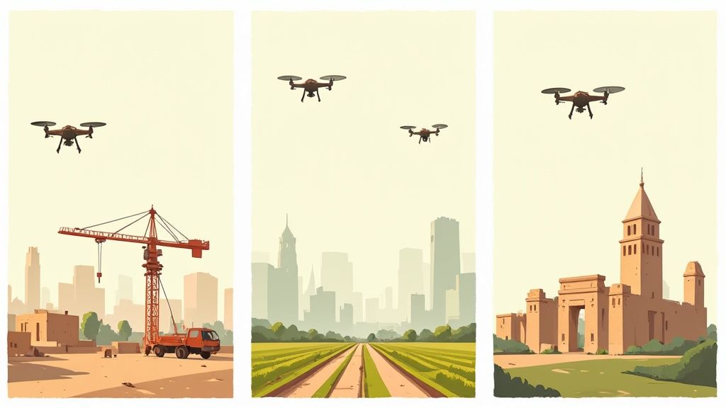
The image below shows how a drone typically gathers data across different types of land. It uses scanning methods to create an initial 3D point cloud, which is the foundation for the final model.
This picture makes it clear that a systematic approach to collecting aerial data is crucial for building accurate digital versions of real-world environments.
Selecting the Right Drone Hardware
When you're aiming for professional drone 3D mapping, your average consumer drone probably won't cut it. Drones built specifically for mapping come with features focused on precision and dependability. Here are some key hardware aspects to look for:
High-Resolution Cameras: You'll want sensors with 20MP or higher and global shutters. These are essential for capturing sharp, clear images without distortion, which is vital for generating accurate models. A global shutter exposes the entire sensor instantly, avoiding the wobbly "jello effect" that can happen with rolling shutters when the drone is moving.
Advanced GPS Systems: For survey-grade accuracy, seek out drones with RTK (Real-Time Kinematic) or PPK (Post-Processed Kinematic) technology. These systems can achieve centimeter-level precision. This greatly reduces the need for lots of ground control points and makes your drone 3D mapping data much more accurately georeferenced.
Sufficient Payload Capacity: The drone needs to easily carry the camera or sensor you're using (like LiDAR for seeing through dense trees) without overworking its motors or drastically cutting down its flight time. This flexibility is important for different kinds of projects.
Extended Flight Times: Drones that can stay in the air longer, ideally for 30 minutes or more, can cover bigger areas in one go. This makes large drone 3D mapping projects more efficient and means fewer battery changes.
Navigating Drone 3D Mapping Software
While the drone and its sensors gather the initial data, it's the software that performs the magic of turning aerial images into usable 3D models and orthomosaics. The need for capable software is growing fast; the global 3D drone mapping software market was valued at about $2.1 billion in 2023. It's projected to soar to $7.4 billion by 2032. You can find more details on this market trend in Fact.MR's research on the drone mapping market.
Picking the right photogrammetry software means looking at its features, how well it processes data, and if it fits your project's specific demands. Processing power is a big deal, as large datasets from extensive drone 3D mapping flights can take a lot of computing horsepower, which can affect your project timelines. For a look at various platforms, consider exploring resources like 2025's Best Drone Mapping Software Guide.
To help you understand the different types of photogrammetry software available, here's a comparison:
Popular Drone Mapping Software Comparison Comparison of leading photogrammetry software platforms showing features, pricing, and ideal use cases
Software Category | Key Features | Pricing Model | Best For |
|---|---|---|---|
Entry-Level / Hobbyist Software | Basic 3D model & orthomosaic creation, limited Ground Control Point (GCP) support, often uses cloud processing | Subscription or one-time purchase fee | Small projects, learning the ropes, users with less powerful computers |
Professional Software | Advanced processing algorithms, strong GCP/MTP support, detailed analytics, volumetric calculations | Higher-tier subscription, perpetual licenses available | Surveying, construction sites, large-scale mapping projects, high-accuracy needs |
Specialized Software | Industry-specific tools (e.g., vegetation indices for agriculture, infrastructure inspection features), AI-driven analytics | Usually premium pricing, may involve specialized add-on modules | Niche uses that require outputs beyond standard 3D models for drone 3D mapping |
This table shows that the software choice depends heavily on project complexity and accuracy requirements. Entry-level options are great for smaller tasks, while professional and specialized software provide the robust tools needed for demanding, high-precision work.
Ultimately, putting together an effective drone 3D mapping setup means understanding how the hardware and software components work together. Your budget should realistically cover the drone itself, any sensors, software licenses or subscriptions, and possibly a powerful computer for processing. This ensures you can consistently deliver professional-quality results.
Planning Missions That Capture Everything You Need
Great drone 3D mapping results depend heavily on careful mission planning. This upfront work is what truly sets professional surveys apart from casual flights. The choices you make before the drone even lifts off have a direct impact on your data's quality and the project's overall outcome. This thoughtful preparation helps ensure you gather all the essential information correctly and effectively.
Designing Flight Patterns for Complete Coverage
The core of any effective drone 3D mapping mission is a well-designed flight pattern. Experienced operators create these patterns to ensure every part of the target area is covered, avoiding any gaps in the data. For example, a frequently used method is the grid pattern, where the drone flies back and forth in parallel lines. When dealing with more intricate structures, a double grid pattern, which adds a second set of flight lines perpendicular to the first, is often chosen to capture finer details.
Calculating the optimal overlap percentages between images is equally vital. Typically, a front overlap of 70-80% and a side overlap of 60-75% are advised for most types of terrain. This repetition allows photogrammetry software to accurately piece the images together. Furthermore, choosing the right flight altitude involves a trade-off: lower altitudes provide higher resolution data (a better Ground Sampling Distance, or GSD, often aiming for 2-5 cm/pixel), but they also mean longer flight times. Higher altitudes can cover areas more quickly but with reduced detail, a balance that needs to be struck based on what the project requires.
Critical Factors for Data Accuracy and Quality
Beyond flight paths and image overlap, several other components are crucial for achieving accurate drone 3D mapping. The careful placement of Ground Control Points (GCPs) is one such element. These are clearly marked targets on the ground with precisely measured coordinates. Using GCPs can greatly enhance the global accuracy of your 3D models, ensuring they align correctly with real-world coordinate systems. Even if your drone is equipped with RTK/PPK technology, a few GCPs can act as useful checks to confirm accuracy.
Weather conditions also play a larger part than many newcomers expect. Consistent lighting conditions are best, which means overcast days can often be more suitable than bright, sunny days that might create long, hard shadows. Wind is another significant factor; strong winds can lead to blurry images and make it hard for the drone to stick to its planned flight path, directly affecting the quality of your drone 3D mapping data. For individuals new to drone flying, mastering basic flight controls is essential before attempting complex mapping missions. You might find this guide useful: How to Fly a Drone for Beginners: Get Started Today.
Advanced Techniques and Streamlining Tools
For more specific drone 3D mapping projects, certain advanced methods can significantly improve your outcomes.
Corridor mapping is extremely helpful for linear projects such as roads, railways, or pipelines, using flight plans designed specifically for long, narrow areas.
Oblique photography, which involves capturing images at an angle rather than straight down (nadir), is essential for modeling vertical surfaces like building facades, offering a more complete 3D view.
Multi-altitude strategies mean flying over the same area at various heights to capture both the overall scene and specific fine details where necessary.
To handle these complexities, many professionals use automated flight planning tools. These software applications simplify the design of missions, letting users define the area they want to map, set overlap percentages, altitude, and camera settings. This automation not only saves time but also promotes consistency and reduces the chance of human error, making even intricate drone 3D mapping projects easier to manage and repeat.
Transforming Raw Images Into Professional 3D Models
Once your drone mission is planned and the data is in hand, the real work begins: turning those hundreds, or even thousands, of raw aerial photos into useful 3D models. This is where the magic of photogrammetry happens, transforming raw images into something truly impressive for your clients. Knowing the steps involved helps you decide whether to prioritize quick results or pinpoint accuracy for your drone 3d mapping project.
The Core Photogrammetry Pipeline
Getting from separate photos to a complete 3D model involves a clear set of steps known as the photogrammetry workflow. Grasping this process is crucial for getting the best outcomes in drone 3d mapping. First up is initial image alignment. Software looks for matching points in your overlapping pictures to figure out where the camera was for each shot. This creates a basic outline, a sparse point cloud, which is the starting point for your model.
Next, dense cloud generation takes those camera positions and builds a far more detailed collection of 3D points—often millions of them. This dense cloud gives a much better picture of the actual surfaces your drone saw, laying the groundwork for a really detailed final product.
With the dense cloud ready, a 3D mesh is built. Think of this as connecting the dots to create a solid surface, made up of countless tiny triangles, which forms the "skin" of your 3D model. Finally, texture mapping drapes the original photos over this mesh. This gives the model its realistic, photographic look, making your drone 3d mapping project truly come alive.
Optimizing for Speed vs. Accuracy
Every step in this process has settings you can tweak. This often leads to a classic choice in drone 3d mapping: do you want it fast, or do you want it perfect? This is the speed versus accuracy dilemma. For instance, creating a more packed point cloud or a super-detailed mesh will give you amazing detail, but it will also take a lot longer to process. This means that you really need to think about what settings you choose.
Knowing what your project needs is top priority. If you just need a quick look, lower quality settings might be fine. But if you're producing a survey-grade model, you’ll need to crank up the accuracy, even if it means more waiting. Managing processing times realistically is key so you can let your clients know what to expect from your drone 3d mapping work.
Handling Large Datasets and Troubleshooting
Big drone 3d mapping projects can create massive datasets—we're talking hundreds of gigabytes sometimes. Pros figure out smart ways to handle all this information, like using beefy computers or cloud services. This keeps their systems from getting bogged down and makes sure everything runs smoothly.
Even with the best planning, you might run into reconstruction errors, like parts of the model not lining up or having gaps. Knowing how to fix these problems—maybe by tweaking settings, getting better photos, or using more ground control points—is a really important skill. Good flight safety practices also help prevent issues that could mess up your data. For more on this, you might find this article useful: Enhancing Flight Safety with Drone Collision Avoidance.
Quality Control for Professional Standards
Before you hand anything over, the last step is a thorough quality control check. This means looking over the 3D model very carefully to make sure it’s accurate, complete, and looks right. You want to be confident that your drone 3d mapping results are solid.
In fields like surveying and engineering, it's absolutely critical to check that the model hits specific accuracy targets. This could mean checking it against known ground points or making sure all the shapes and sizes are correct. Such measures ensure your final deliverables meet professional surveying standards and satisfy your clients, proving the worth of your drone 3d mapping services.
Real-World Applications Driving Industry Transformation
The ability to turn aerial images into detailed three-dimensional models has unlocked a host of practical uses for drone 3D mapping in many different fields. This isn't just a minor upgrade; it’s profoundly reshaping how industries function and approach decision-making. By looking at specific examples, we can really grasp the exciting opportunities that drone 3D mapping offers.
Construction: Enhancing Project Oversight and Efficiency
When it comes to construction, drone 3D mapping offers some seriously useful tools for progress monitoring and making precise volume calculations. Imagine site managers getting fresh 3D models on a regular basis. They can easily see how construction is matching up to the plans, spot problems before they get big, and keep everyone in the loop with visual updates.
Tasks like figuring out the volume of material stockpiles or how much earth has been moved used to be a slow, manual slog. Now, thanks to drone data, these calculations are super fast and incredibly accurate. For jobs like checking earthwork, the precision needed is often down to the centimeter-level.
Environmental Science: Monitoring Our Changing World
Environmental scientists are finding drone 3D mapping invaluable for keeping an eye on how landscapes change over time, with more detail than ever before. This technology is being used for a variety of critical tasks.
Some key applications include:
Monitoring how coastlines are eroding.
Assessing the extent of deforestation.
Tracking the melt of glaciers.
Evaluating the success of ecological restoration efforts.
Being able to gather high-resolution data so often means researchers can create detailed time-series analyses. These methods give a clearer picture of environmental shifts and how well conservation work is paying off.
Urban Planning: Building Smarter Cities
City planners are also getting on board, using drone 3D mapping to help build smart city initiatives. The detailed aerial models created by drones form a solid base for planning new infrastructure, running simulations for traffic management, and working on sustainable development projects. This growing use is mirrored in the overall 3D mapping and modeling market itself, which is experiencing quite a boom.
The market was valued at around $7.89 billion in 2024 and is forecasted to reach $9.22 billion in 2025. That’s a compound annual growth rate (CAGR) of 16.8%. Looking ahead, experts predict the market will expand to $18.83 billion by 2029, growing at a CAGR of 19.5%, thanks to things like more people moving to cities and better computer graphics. You can dive deeper into the full 3D mapping and modeling market outlook to learn more.
Identifying New Market Niches
It's not just the well-known sectors that are benefiting; drone 3D mapping is also carving out new business avenues in several up-and-coming market areas. For example, the agriculture industry uses this tech for precision farming, helping to manage crops more effectively. Insurance companies are finding it useful for assessing damage after an incident.
Even real estate gets a boost from stunning aerial views that can make listings pop. If you're in real estate, you might find our guide on Drone Real Estate Photography: Tips to Boost Listings helpful. Understanding these diverse uses and their particular needs for accuracy helps service providers find their spot in this expanding market for drone 3D mapping.
Emerging Technologies Shaping The Future Of Aerial Mapping

While current applications of drone 3D mapping are already making a substantial impact across various industries, the technology itself is constantly progressing. The field is advancing quickly, with several new technologies ready to further improve and broaden the abilities of aerial surveying. Keeping up with these developments is crucial for anyone aiming to be at the leading edge of drone 3D mapping.
The Rise of AI and Machine Learning
One of the most notable advancements is the growing use of artificial intelligence (AI) and machine learning (ML) within drone 3D mapping procedures. These technologies are automating many data processing tasks that have traditionally taken a lot of time. For instance, AI algorithms can now automatically sort point cloud data or pinpoint specific features in a mapped area with remarkable speed. This means that the journey from capturing data to producing a final, usable 3D model can be significantly shortened, often with better accuracy too.
Real-Time Mapping Capabilities
Another exciting area is the growth of real-time mapping functions. In the past, turning aerial data into a 3D model could take hours, or even days. However, improvements in drone-based processing and fast data transmission are enabling the creation of maps and models almost instantly while the drone is airborne. This immediate feedback is extremely useful in situations that change rapidly. For example, construction managers can make quick decisions based on live progress reports, and emergency teams can assess developing situations on the ground using the latest drone 3D mapping data.
Advanced Sensor Integration
The variety and power of sensors that drones can carry are also increasing, greatly expanding the possibilities for drone 3D mapping. Beyond the usual RGB cameras and LiDAR, we are seeing more integration of:
Multispectral and Hyperspectral Imaging: These sensors gather data from a broader part of the electromagnetic spectrum. This provides rich details for agriculture, environmental observation, and managing natural resources.
Ground-Penetrating Radar (GPR): Some drones can now be equipped with GPR systems. This allows for mapping features below the ground, which is vital for archaeology, locating utilities, and geotechnical studies.
Thermal Imaging: Upgraded thermal sensors deliver detailed temperature maps. These are beneficial for inspecting buildings, checking solar panels, and even for search and rescue operations.
This combination of advanced sensors allows a single drone flight to collect various types of data at the same time. This makes drone 3D mapping operations more effective and provides deeper insights than previously possible. Staying current with these technological developments helps professionals choose the right equipment and get ready for the new possibilities that will shape the industry's future.
Key Takeaways For Your First Mapping Project
Even as technology advances aerial surveying, getting started with drone 3D mapping really comes down to good preparation and hands-on know-how. If you want your first drone mapping project to be a success, it’s important to grasp the key steps that build quality and trust right from the beginning. Here’s a straightforward guide to help you navigate these early stages.
Essential Preparation for Success
When it comes to professional drone 3D mapping, solid prep work isn't just recommended—it's essential. First off, make sure you have all the necessary certifications to fly commercially in your area. Flying without them can cause serious problems.
Equally vital is a thorough site assessment before you even think about launching your drone. This means scouting for any obstacles, getting a feel for the land, and checking airspace rules to make sure your flight is both safe and productive.
Finally, setting clear project goals with your client is absolutely key. You need to fully understand what they hope to achieve and set realistic accuracy expectations based on your gear and mapping techniques. This kind of clarity helps avoid confusion later and makes sure the final deliverables satisfy your client.
Communicating Effectively and Avoiding Common Pitfalls
Seasoned pros know how important it is to communicate both the strengths and weaknesses of drone 3D mapping to their clients. Being upfront about what’s possible (and what’s not) builds trust and keeps expectations in check. For example, it's wise to talk about how things like bad weather or thick trees could affect the final 3D model.
Newcomers often run into trouble with mistakes that could have been avoided. Some common slip-ups include:
Not enough image overlap, which can create holes in your 3D model.
Sloppy flight planning that results in missed spots or uneven data collection.
Forgetting about Ground Control Points (GCPs) or using them incorrectly, especially when high precision is a must. These kinds of mistakes can really hurt your reputation, so careful planning is your best defense in any drone 3D mapping endeavor.
Building Scalable Workflows and Ensuring Quality
As you get more experienced with drone 3D mapping, you’ll naturally want to develop workflows that can grow with your operations. This means creating standard procedures for everything, from planning your flights to delivering the final data. A core part of any reliable operation is solid safety planning, which covers everything from pre-flight checks and emergency plans to being aware of the weather and environment.
An equipment checklist is an indispensable aid for any mapping flight. Always double-check that every piece of your gear is working perfectly before you take off. This methodical routine greatly reduces the chances of something going wrong mid-flight or ending up with bad data.
To help with this, a detailed pre-flight checklist is invaluable. Here's a breakdown of key items to consider before any mapping mission:
Pre-Flight Checklist for Mapping Missions Essential steps and considerations for planning and executing professional drone mapping flights
Category | Checklist Items | Critical Level | Notes |
|---|---|---|---|
Regulations | Verify local flight authorizations, airspace class, and NOTAMs. Ensure operator certification is current. | High | Non-compliance can lead to severe penalties. |
Site Assessment | Physical site walk (if possible), identify hazards (power lines, towers, trees), assess terrain variability. | High | Essential for safe flight paths and avoiding obstacles in drone 3D mapping. |
Project Setup | Confirm project objectives, required accuracy, GSD. Define mapping area and boundaries clearly. | High | Aligns mission parameters with client deliverables for drone 3D mapping. |
Equipment | Drone batteries charged, firmware updated, props secure, gimbal check, sensor clean, controller charged. | High | Equipment failure is a common cause of mission abortion or poor data. |
Flight Plan | Overlap settings (e.g., 70% front, 60% side), flight altitude, speed, camera settings (ISO, shutter). | High | Incorrect parameters directly impact the quality of drone 3D mapping outputs. |
GCPs (if used) | GCPs distributed effectively, clearly visible from air, coordinates recorded accurately. | Medium-High | Crucial for survey-grade accuracy if RTK/PPK is not primary or for validation. |
Safety | Weather check (wind, precipitation, visibility), emergency procedures reviewed, observer briefed (if applicable). | High | Safety is paramount; never fly in unsafe conditions. |
Data Management | Sufficient memory card space, data transfer plan post-flight. | Medium | Ensures all captured drone 3D mapping data can be stored and processed. |
Using such a checklist consistently helps ensure that no critical step is overlooked, leading to safer flights and higher quality data.
Lastly, don't forget about strong quality control measures. Always take the time to carefully examine your processed data and the resulting 3D models. This ensures they line up with the accuracy levels you aimed for and meet all project requirements. Following these practices will help your initial drone 3D mapping projects build a solid reputation for future work.
If you're keen to learn more about the drone world or get into specific drone technologies, check out JAB Drone. They offer expert views, thorough reviews, and all the latest happenings in the drone industry.