Augmented Reality Drones: Transforming Industries Today
- Jab Media

- Aug 19, 2025
- 16 min read
Augmented reality drones are all about blending a live video feed with a layer of interactive, digital information. This process transforms a standard, raw video view into an intelligent, operational display that gives pilots a massive advantage.
Think of it as giving the drone pilot a real-time heads-up display (HUD), just like a fighter pilot has. It overlays crucial data like flight paths, warnings for restricted airspace, and key mission targets directly onto the real-world view from the drone's camera. This creates an experience that's worlds away from just simple video streaming.
What Exactly Are Augmented Reality Drones?
To really get a grip on AR drones, you first have to understand augmented reality (AR) itself. It’s not like virtual reality (VR), which drops you into a completely digital world. Instead, AR takes our existing reality and enhances—or augments—it with computer-generated info. It's like having a video game's interface brought to life, where vital stats and markers appear on your screen to guide you through the real world.
Now, picture that concept strapped to a drone. An AR drone doesn’t just show you what its camera sees; it paints a much richer, more informative picture. It fuses its live video stream with data from its onboard sensors—like GPS, computer vision, and LiDAR—to create an interactive and contextualized view of the environment.
The Core Fusion of Technologies
The real magic behind augmented reality drones is the seamless way several key technologies come together. Each piece of the puzzle plays a critical role in delivering that final, data-rich experience to the person at the controls. This isn't just some software trick; it's a deep fusion of hardware and intelligent algorithms working in perfect sync.
This combination of hardware and software allows the drone to understand its precise position and the world around it with incredible accuracy. This spatial awareness is the bedrock upon which all AR features are built, turning a simple camera feed into a powerful decision-making tool.
The essential components that make this happen include:
Computer Vision: This is the "eyes" of the system. It lets the drone identify and track objects in real time, whether they're people, vehicles, or specific points of interest. It's what makes sense of all the visual data pouring in.
Advanced Sensors (GPS, IMU, LiDAR): These components provide the raw data for location, orientation, and environmental mapping. GPS places the drone in the world, while an IMU tracks its movement and LiDAR can build detailed 3D maps of the surroundings.
High-Speed Data Processing: You need a powerful onboard brain to analyze all this sensor data and render the AR overlays without any noticeable lag. This real-time performance is absolutely crucial for any mission-critical application.
The goal is to provide superior situational awareness. AR overlays for street names, house numbers, and points of interest make orientation easy, helping all stakeholders quickly understand every situation.
Beyond a Simple Video Feed
What you get in the end is an operational view that is fundamentally different from what a standard drone provides. Instead of just seeing a building, an AR drone pilot might see that same building with its digital blueprints overlaid perfectly on top of it.
A first responder wouldn't just see a street; they'd see that street with highlighted escape routes, a suspect's last known position, or the real-time locations of other emergency units.
This technology elevates the drone from a passive observer into an active, intelligent participant in an operation. The pilot is no longer just flying a camera; they're interacting with a live, intelligent map projected directly onto reality. This shift empowers operators to make faster, more informed, and ultimately safer decisions, whether they're inspecting a wind turbine or coordinating a complex search and rescue mission.
The Technology Powering AR Drones
At first glance, an AR drone might just look like any other quadcopter on the market. But pop the hood, and you'll find a completely different beast. It's not just a simple upgrade; we're talking about a sophisticated ecosystem of specialized hardware and software, all working in concert. The whole system is re-engineered from the ground up to handle a complex dance: perceiving the world, crunching massive amounts of data, and projecting digital information onto a live video feed—all without a hint of lag.
Every single component is chosen to support this demanding job. The goal is to create an AR experience that’s smooth, accurate, and truly useful for missions where every second counts.
Advanced Hardware: The Sensory Core
The hardware is the drone's physical connection to the world, gathering all the raw data needed to make sense of its surroundings. Standard drones are all about the camera, built for beautiful photos and videos. Augmented reality drones, on the other hand, are loaded with an entire suite of advanced sensors working together.
High-resolution cameras are just the beginning. These drones often feature specialized sensors to see what the human eye can't.
LiDAR Scanners: Think of these as the drone's eyes for building a 3D world. They shoot out laser pulses to create incredibly precise, real-time 3D maps of the environment. This is the secret sauce for placing AR objects perfectly and navigating complex spaces.
Thermal Cameras: By picking up on heat signatures, these cameras let operators see right through smoke or complete darkness. This thermal data gets layered onto the visual feed, a game-changer for search and rescue or industrial inspections.
Powerful Onboard Processors (GPUs): You can't render complex AR graphics without some serious muscle. These drones have high-performance GPUs right on the aircraft to process all that sensor data and generate overlays in an instant.
This image gives you a quick idea of how much power these specialized components really need.
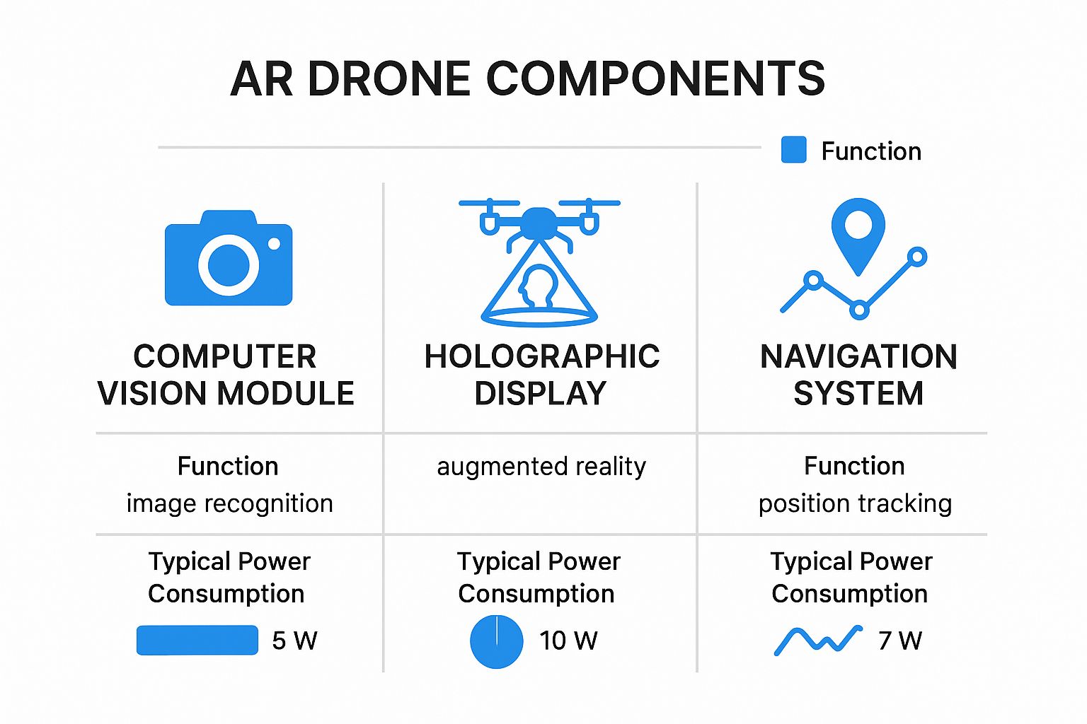
As you can see, things like a holographic display and computer vision module are power-hungry, which is exactly why you don't find them on your average drone.
The Software Brain: Interpreting Reality
If the hardware collects the data, the software is what makes sense of it all. The software on an AR drone is lightyears beyond a simple flight controller. It relies on sophisticated algorithms to take all that sensor input and turn it into something meaningful.
Computer vision is the real star of the show here. These algorithms give the drone the ability to recognize and track objects, read signs, and genuinely understand what it’s looking at. This is what allows the system to "anchor" digital graphics to real-world objects so they stay put, even as the drone flies around.
The goal is to make situational awareness easy. AR overlays for street names, house numbers, and points of interest help all stakeholders quickly orient themselves to every situation.
This magic is made possible by specialized AR development kits (SDKs) and platforms. These are the toolkits developers use to build custom apps that project specific data—anything from architectural blueprints on a construction site to hazard warnings for first responders.
A Clear Distinction From Standard Drones
To really grasp the technological leap, it helps to put a standard consumer drone and a purpose-built AR drone side-by-side. The differences are stark, and they highlight why you can't just download an app to get true AR capabilities. The entire system is engineered for a completely different mission.
Let's break down the key component differences in a simple table.
Standard Drones vs. Augmented Reality Drones: A Component Comparison
This table really puts the technological gap into perspective, showing how AR drones are built from the ground up for data fusion and real-time interaction, not just capturing pretty pictures.
Component | Standard Drone | Augmented Reality Drone |
|---|---|---|
Primary Sensor | High-resolution camera for photography and videography. | A multi-sensor array including LiDAR, thermal, and high-res cameras for comprehensive data capture. |
Processing Unit | Standard CPU for flight control and basic video processing. | High-performance GPU for real-time 3D rendering and complex data analysis. |
Data Link | Standard radio link optimized for video transmission with acceptable latency. | Ultra-low latency, high-bandwidth link to ensure immediate AR overlay response without lag. |
Software Focus | Flight stability and camera control. | Computer vision, object recognition, and real-time data fusion. |
Ultimately, while they might both fly, a standard drone is a camera in the sky, while an AR drone is a powerful, flying computer designed to interpret and augment the world around it.
How AR Drones Are Transforming Industries
The real magic of augmented reality drones isn’t just the tech itself—it's what people are doing with it to solve real-world problems. Across several key sectors, these intelligent flying platforms are graduating from cool concepts to indispensable tools, bringing tangible benefits like better efficiency, beefed-up safety, and serious cost savings.
By layering critical digital information over a live view of the physical world, AR drones give professionals a level of insight that was simply science fiction a decade ago. This is changing how work gets done, replacing outdated maps and slow manual inspections with a live, data-rich perspective.
Revolutionizing Construction and Infrastructure
The construction industry is a perfect example of where augmented reality drones are already making a huge difference. On any job site, there's a constant battle to make sure the physical structure perfectly matches the digital blueprint. When they don't line up, it leads to expensive mistakes and frustrating delays. AR drones are the ultimate bridge between the digital plan and the physical reality.
When a drone flies over a site, it can project the digital Building Information Modeling (BIM) plans directly onto the live video feed. This gives project managers an instant, bird's-eye view to confirm everything is being built exactly to spec.
It allows them to spot problems in seconds:
Progress Verification: Are walls, foundations, and other structural elements in the right place? Now you can see it instantly.
Clash Detection: Spot where newly installed plumbing or electrical runs might conflict with the digital model before it becomes a nightmare to fix.
Quality Control: Ensure that materials and installations meet the precise specifications laid out in the blueprints.
This kind of immediate visual confirmation slashes the need for time-consuming manual checks and stops tiny errors from snowballing into million-dollar problems. To get the full picture of how these foundational models are created, check out our guide on **drone 3D mapping**, which breaks down how aerial tech is reshaping entire industries.
Enhancing Public Safety and Emergency Response
In a public safety crisis, every second counts and good information is gold. AR drones are quickly becoming a vital tool for first responders, delivering a powerful dose of situational awareness when the stakes are highest.
Imagine a search and rescue mission. An AR drone can soar over a vast area, projecting a search grid directly onto the operator's screen to make sure no ground is missed. If the drone is equipped with a thermal camera, it can highlight heat signatures, making it far easier to spot a missing person in thick woods or after dark.
Augmented reality overlays for street names, house numbers, and points of interest make situational awareness easy, helping all stakeholders quickly orient themselves to every situation.
This technology truly shines in chaotic, fast-moving situations. During a major fire, for instance, an AR drone can overlay a building's floor plans onto the live video of the structure, showing firefighters the layout and pinpointing known hazards. This gives command centers the intelligence they need to make smarter, faster decisions that save lives—both civilian and responder.
The chart below from Grand View Research highlights just how much the drone market is growing, with emergency services being a major driver of that expansion.
This data really drives home the demand for more advanced drone capabilities, especially in fields where real-time information and safety are everything.
Optimizing Precision Agriculture
Farming today is all about data. The goal is to maximize every harvest while using as few resources as possible. AR drones are taking precision agriculture to a whole new level by completely changing how farmers see and manage their land.
Outfitted with multispectral sensors, these drones can pick up on subtle signs of crop stress that are totally invisible to the human eye.
But instead of just generating a static map you look at later, an AR drone projects this health data right onto the live view of the fields below. A farmer can see color-coded overlays showing exactly which patches are healthy, which ones need water, and which might be dealing with pests or a lack of nutrients. This allows for an incredibly targeted use of resources—instead of watering an entire field, a farmer can hit just the struggling sections, saving water, time, and money.
Boosting Logistics and Disaster Management
The influence of augmented reality is also being felt in logistics and disaster management, where it's helping drive wider drone adoption. In logistics, AR drones can smooth out last-mile delivery by helping operators visualize safe flight paths, spot obstacles like power lines, and even see digital markers for drop-off points in busy urban areas.
When disaster strikes, these drones become critical for coordinating a complex response. They can overlay maps of clear roads, survivor locations, and hazardous zones onto the real-world view, allowing relief teams to react faster and more effectively.
Giving Drone Pilots a Safer Way to Train with AR
There’s more to mastering an advanced drone than just logging flight hours. It takes precision, lightning-fast decision-making, and a cool head in high-stress situations. This is where augmented reality is completely changing the game for pilot training, swapping risky real-world practice for safe, immersive, and seriously effective simulations.
AR-powered simulators build out hyper-realistic training worlds where pilots can push their limits without putting a single piece of expensive hardware on the line. Think of it as a flight dojo—a place to practice, fail, and learn in a totally controlled space. New pilots get to build that crucial muscle memory and confidence, while seasoned pros can sharpen their skills for the toughest missions imaginable.
Creating a Risk-Free Digital Twin
The real power of AR training lies in its ability to simulate dangerous or tricky scenarios that are just impossible to safely replicate in the real world. A pilot can run through an engine failure protocol, navigate a sudden violent storm, or maneuver through a crowded urban canyon, all from the safety of a training room.
These simulators can overlay critical flight data with pinpoint accuracy, perfectly mimicking the heads-up display a pilot would see in the field. This gets trainees comfortable with managing a constant stream of information while flying the aircraft. The whole experience is designed to feel as real as possible, so the skills learned in the sim translate directly to real-world flights.
Here are a few key scenarios pilots can drill:
Emergency Response: Simulating equipment failures like GPS loss or a motor malfunction to test a pilot's reaction under pressure.
Extreme Weather: Throwing in dynamic conditions like high winds, heavy rain, or thick fog to build adaptability.
Complex Environments: Replicating challenging flight paths through dense cityscapes or around critical infrastructure.
The Real-World Benefits of AR Simulation
Shifting to AR-based training isn't just about safety; it brings huge operational and financial wins. By cutting down on the need for physical drones for basic and intermediate training, organizations can slash costs tied to fuel, maintenance, and potential crash damage.
This method also puts skill development on the fast track. Pilots can repeat a difficult maneuver dozens of times in one session—something that would take days and a lot of resources out in the field. This compressed learning cycle gets pilots mission-ready much faster, a massive advantage for any organization needing to deploy skilled operators quickly. Our guide to **drone photography for beginners** stresses the importance of practice, and simulators make that easier than ever.
The ultimate benefit is a massive increase in operational safety. A pilot who has faced and overcome a dozen simulated emergencies is far better prepared to handle a real one, protecting both the mission and the public.
The market trends tell the same story. The global drone simulator market was valued at USD 1.4 billion and is projected to skyrocket to USD 7.7 billion by 2034. Within this booming market, augmented reality simulators are the clear front-runner, grabbing over 65.5% of the share by device type because they offer the most realistic and effective training out there. You can dig into more details on this growth on Market.us.
Overcoming Key Challenges in AR Drone Adoption
While the potential of augmented reality drones is massive, the road to seeing them everywhere isn't exactly a smooth flight. Getting from a cool prototype to an industry-standard tool means we have to navigate some serious technical, regulatory, and even financial roadblocks. Taking an honest look at these hurdles shows us what it’ll take for this technology to truly take off.
The most immediate challenge is a technical one. AR drones are absolute data hogs, demanding an incredible amount of processing power. To render complex digital graphics over a live video feed in real-time, you need a powerful onboard GPU. The problem? That GPU adds weight, drains the battery faster, and cranks out heat—all things you want to avoid on a flying machine.
On top of that, a good AR experience hinges on a rock-solid, high-speed data connection. Any lag or "jitter" between what the pilot does and what they see can make the whole system useless, especially when precision is key. This chase for ultra-reliable connectivity is a huge focus for developers right now.
Navigating Technical and Processing Hurdles
To get a real sense of the demand, think about the sheer volume of data an AR drone is crunching every single second. It’s not just streaming video. It's simultaneously running computer vision algorithms to understand the environment, tracking objects, and rendering 3D graphics on the fly. That requires a level of computational horsepower that’s leagues beyond your standard camera drone.
A few key technical obstacles stand out:
Onboard Processing Power: Cramming a GPU powerful enough for real-time rendering into a small, light, and power-efficient drone is a constant engineering tightrope walk.
Latency and Connectivity: The system needs a near-instant data link. Any delay can throw off the pilot, disrupt a mission, or even cause them to lose control.
Sensor Fusion Complexity: Seamlessly blending data from multiple sources—like LiDAR, thermal cameras, and GPS—into a single, coherent AR display without glitches is a major software puzzle.
The core issue is that for AR to feel right, it has to feel like a natural extension of reality. Any technical hiccup, from a delayed overlay to misplaced data, shatters that illusion and breaks the operator's trust in the system.
Cracking these problems is the only way this tech moves from niche experiments to mainstream, everyday use.
Untangling the Regulatory Web
Beyond the tech itself, a tangled web of regulations presents another big hurdle. Many of the most powerful uses for augmented reality drones, like inspecting critical infrastructure or aiding in emergency response, require flying beyond visual line of sight (BVLOS).
Unfortunately, aviation rules in many parts of the world are still playing catch-up. Getting the official waivers needed for BVLOS flights is often a slow, complicated process, which really puts the brakes on deploying these advanced drone programs. As the drones become more autonomous, regulators will need to establish clear, standard rules to make sure they can operate safely alongside other aircraft. Many in the agricultural sector are already pushing through these issues; you can see how another industry is tackling this by exploring how drones are redefining modern agriculture.
Finally, you can’t ignore the economics. AR drones are a significant upfront investment compared to their standard counterparts. And it’s not just the hardware cost. Organizations also have to factor in specialized pilot training and the software platforms needed to manage all that AR data, adding another layer to the total price tag.
The Future of Flight Is Augmented
The AR drone technology we see today is genuinely impressive, but it’s really just the opening act. The future of flight isn't just about putting data overlays on a screen; it's about creating intelligent aerial partners that can anticipate our needs, predict outcomes, and work with us in ways that will completely redefine what autonomous operations look like. This next wave will be driven by the powerful combination of AR, artificial intelligence (AI), and machine learning.
Think about it this way: instead of a drone simply showing a pilot where a target is, a future drone will use AI to analyze its movement, predict its path, and suggest the best ways to intercept it. This transforms the technology from a passive display into an active, strategic tool, giving operators a massive advantage with predictive insights. It's this exact shift that's fueling the explosive growth we're seeing in the drone market.
Smarter, Faster, and More Connected Skies
Several key trends are pushing this evolution forward. The relentless drive for sensor miniaturization means tomorrow’s drones will pack even more data-gathering power into smaller, nimbler airframes. At the same time, the rollout of 5G connectivity is poised to finally crush today's bandwidth limits, allowing for flawless, high-definition AR data streaming from entire fleets of drones.
These advancements are opening the door to some incredible possibilities:
Collaborative Drone Swarms: Imagine swarms of drones working together, sharing AR data to build a live, interactive digital twin of an entire city. This would give urban planners and emergency responders a real-time, god-like view of their environment.
Intuitive AR Interfaces: Future interfaces will likely move beyond just screens. We're talking AR glasses that make data overlays feel like a natural extension of the pilot's own vision.
Proactive AI Assistance: Drones will start taking the initiative. They'll autonomously identify points of interest, flag potential structural weaknesses on an inspection, or suggest safer flight paths—all without a human needing to ask.
The ultimate goal here is to create a seamless fusion of human intuition and machine intelligence. The AR interface will become so natural that it feels less like you're operating a tool and more like you've gained a new sense.
The New Standard for Autonomous Flight
This deep integration of AR is a huge reason why drone applications are advancing so quickly. The global drone market, currently valued at around USD 73.06 billion, is on track to hit USD 163.60 billion by 2030, largely because of these souped-up autonomous capabilities. AR’s ability to overlay critical data is at the very heart of this growth, changing how decisions are made in complex situations. You can find more insights on this market projection over at GrandViewResearch.com.
As this technology gets more powerful, staying on top of the rules of the sky will be more crucial than ever. For a deep dive into the legal side of things, make sure you check out our [comprehensive guide to understanding drone regulations](https://www.jabdrone.com/post/understanding-drone-regulations-a-comprehensive-guide-for-every-country), which covers everything a pilot needs to know.
Augmented reality isn't just a cool add-on anymore; it's becoming a foundational technology that will define the next era of smart, autonomous flight.
Common Questions About Augmented Reality Drones
As this powerful technology starts showing up more often, it’s natural to have questions. Getting a handle on the core benefits, limitations, and the skills needed to fly one is key to understanding just how much AR drones are changing things. Here are some straightforward answers to the questions we hear most.
What Is the Main Benefit of an AR Drone?
The single biggest advantage is a massive boost in situational awareness. By layering critical digital information right on top of the drone's live video, AR gives pilots instant context that a simple camera feed could never match. This leads to faster, more accurate decisions during complex jobs.
Think about it: an inspector can see structural plans overlaid on a bridge in real-time. A first responder can get a suspect’s last known location marked directly on the terrain. This blend of the real and digital worlds cuts out the guesswork and makes every operation more effective.
Can I Turn My Regular Drone into an AR Drone?
For the most part, no. Real augmented reality drones aren't just a software upgrade; they rely on specialized hardware that most consumer drones just don’t have. Trying to run AR on a standard drone would be like trying to play a brand-new, graphics-heavy video game on a ten-year-old laptop—it simply won't work right.
These purpose-built systems need some serious hardware:
Powerful onboard processors (GPUs) to render all that digital information without a hint of lag.
Advanced sensors like LiDAR to map the environment accurately.
High-speed, low-latency data links to keep the AR experience smooth and responsive.
Which Industries Use AR Drones the Most?
While more sectors are catching on, a few key industries have jumped out as early leaders. These are fields where having precise spatial data and remote visual confirmation gives them a huge operational edge.
The biggest users right now include:
Construction: To compare as-built structures against digital BIM models on the fly.
Public Safety: For coordinating search and rescue missions and tactical operations with live data.
Agriculture: To visualize crop health data, guiding precision farming efforts from the air.
Utilities: For inspecting critical infrastructure with diagnostic data overlaid directly on the equipment.
What Skills Does an AR Drone Pilot Need?
It goes way beyond just knowing how to fly. An AR drone pilot has to be good at interpreting a dense, constant flow of data in real time. It's one thing to fly a drone, but it's a whole other challenge to fly it while analyzing multiple layers of digital information at the same time.
An effective AR drone operator needs sharp analytical skills and the ability to make quick decisions under pressure. They have to manage both the aircraft and the stream of digital intelligence to get the job done right.
This is why specialized training is so important. Pilots often practice in immersive AR simulators to build the unique skills needed to operate these advanced systems safely and effectively.
At JAB Drone, we're passionate about exploring the future of flight. Whether you're a professional pilot or a curious enthusiast, our expert reviews and in-depth articles provide everything you need to know. Discover more at https://www.jabdrone.com.
Comments