Where to Fly My Drone A Pilot's Guide to Finding Spots
- Paul Simmons

- Oct 8, 2025
- 13 min read
Updated: Oct 9, 2025
Finding a legal spot to fly your drone is about more than just finding a big, open field—it's about understanding the rules of the sky. The sweet spots are usually in uncontrolled (Class G) airspace, well away from airports, national parks, and crowds. The key is always maintaining a clear visual line-of-sight. Luckily, modern apps have become a pilot's best friend for verifying all this in real-time.
Mastering the Rules of the Sky
Before your props even start to spin, getting a handle on the legal landscape is non-negotiable. This isn't just about dodging hefty fines; it’s about being a responsible pilot who knows how to share the skies safely with everyone else.
The core principles are pretty straightforward but absolutely critical. For almost any recreational or commercial flight, you have to keep your drone within your visual line-of-sight (VLOS) at all times. Think of it as the golden rule of drone safety—it ensures you can see and steer clear of potential hazards like trees, power lines, or other aircraft.
Key Regulations to Know
Altitude is another big one. In the United States, the Federal Aviation Administration (FAA) sets a hard ceiling of 400 feet above ground level for most flights. This keeps your drone safely below the altitudes where manned aircraft typically operate.
Don't forget about registration. If your drone weighs more than 250 grams (0.55 pounds), you're required to register it with the FAA. It's a quick, cheap process that officially links the aircraft to you. If you want to dive deeper, you can master the drone laws your essential compliance guide covers everything in detail.
The Rise of Remote ID and Automated Systems
The world of drone regulations has gotten a lot more tech-savvy in recent years. Since 2020, rules have tightened up globally, with major players like the U.S. and the European Union rolling out advanced Remote ID requirements.
By 2025, any drone that needs to be registered must also broadcast a Remote ID signal. It’s essentially a digital license plate, giving authorities real-time location data. This tech is making the skies safer, but it also means you need to be more diligent than ever when picking a spot to fly.
Flying near airports used to be a complicated, manual affair. Now, automated systems have completely changed the game for pilots needing to operate in controlled airspace.
Take the FAA’s LAANC (Low Altitude Authorization and Notification Capability) system, for example. It's an indispensable tool that now processes over 90% of near-real-time airspace authorizations in the U.S. It lets pilots get instant approval for flights in certain controlled zones, right from their drone apps. Getting comfortable with LAANC is a must if your flight plans ever take you near an airport. By embracing these rules and tools, you make sure every flight is not just fun, but fully compliant.
Find Great Flying Spots with Maps and Apps
Guesswork and responsible drone piloting just don't mix. You can't just cross your fingers and hope you're in a legal spot. Thankfully, you don't have to. The modern drone pilot has powerful tools right on their phone to pinpoint safe, legal, and awesome places to fly.
These apps and online maps essentially turn your smartphone into a pre-flight command center. They overlay real-time airspace data onto a map, showing you exactly where you stand in relation to airports, restricted zones, and other sensitive areas. A great starting point for finding wide-open areas are interactive maps to identify open spaces like parks and sports fields in your neighborhood.
Your Digital Toolkit for Safe Flights
If you're flying in the U.S., the first app you need to download is B4UFLY. It's the FAA's official app, and it gives you a simple, clear status for your current location: green, yellow, or red. Think of it as the final word on airspace rules. It's an absolute must-have.
Another heavyweight in this space is Aloft (which actually powers the B4UFLY app). Aloft goes a bit deeper, offering detailed airspace maps, real-time weather, and critical alerts for things like Temporary Flight Restrictions (TFRs). TFRs can pop up with very little notice for major sporting events, wildfires, or VIP movements, making a last-minute check on an app like Aloft a non-negotiable part of any pre-flight routine.
This infographic is a great visual reminder of all the little things you need to check before you even think about taking off.
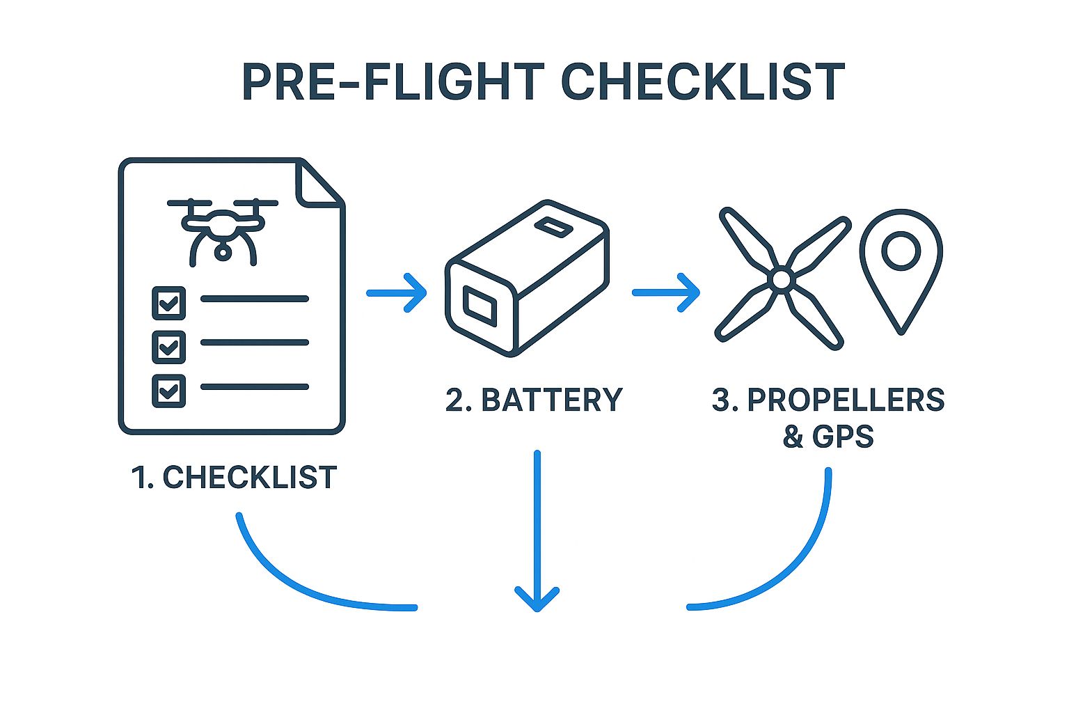
Treating your pre-flight check like a visual checklist helps build good habits. It ensures you never miss a critical step, from checking your battery levels to making sure you have a solid GPS lock.
Making Sense of the Maps (And Getting Authorization)
When you pull up an app like B4UFLY, you'll see a map of your surroundings. Areas near airports will be highlighted, often with grids showing the maximum altitude you can fly with automated approval.
Learning to read these maps is your key to flying with confidence. A clear, unmarked area usually means you're in Class G (uncontrolled) airspace and good to go, as long as you follow the basic FAA rules. If you see a colored-in area or a grid, that’s your signal that you'll need LAANC authorization to fly.
Many pilots find that using a dedicated app streamlines this entire process. For a deeper look at the options out there, we've put together a comprehensive guide on the 12 best drone flight planning app options for 2025.
Here’s a quick rundown of what you’ll be looking for on a typical drone map:
Airport Proximity: You’ll see circles or other shapes around airports. These mark controlled airspace (Class B, C, D, or E).
No-Fly Zones: Places like National Parks and military bases are almost always off-limits. They'll be clearly marked, usually in red.
Altitude Grids: These grids are your friend. They show the maximum altitude (e.g., 100 ft, 200 ft) you can be approved for automatically through LAANC.
To give you a better idea, we've compared some of the most popular apps that pilots rely on every day.
Top Drone Flight Planning Apps Compared
These apps are the go-to choices for pilots who need to check airspace, get weather updates, and secure LAANC authorizations quickly. Each one has its own strengths.
App Name | Key Feature | Best For | LAANC Authorization | Cost |
|---|---|---|---|---|
B4UFLY | FAA-backed status indicators | Quick, simple go/no-go checks | Yes | Free |
Aloft | Detailed maps & TFR alerts | Comprehensive pre-flight planning | Yes | Free (with paid tiers) |
AutoPylot | Mission planning & compliance logs | Commercial pilots needing records | Yes | Subscription-based |
DroneDeploy | Automated mapping & 3D models | Industrial & construction use | Yes | Subscription-based |
AirMap | Global airspace intelligence | Pilots flying internationally | Yes | Free (with paid tiers) |
Choosing the right app often comes down to your specific needs, whether you're a hobbyist looking for a quick check or a commercial operator managing complex missions.
By making these apps a core part of your pre-flight routine, you're doing more than just following the rules—you're being a smarter, safer, and more responsible pilot.
How to Scout Your Location Before You Fly
Finding a great spot on a map is a solid start, but it's only half the battle. The real magic—and the difference between a good flight and a great one—happens when you get your boots on the ground for a site survey before your drone ever leaves its case.
This is where you move from theory to practice. An on-site check confirms the location isn't just legal but is genuinely safe and has the potential for those spectacular shots you're imagining.
When you first arrive, just take a slow walk around. Your main goal here is to spot any nasty surprises that a satellite view would never show you. Remember to look up!
Spotting Physical and Signal Hazards
The most common offenders are those sneaky, thin power lines or telephone wires that seem to vanish against a busy background or a bright sky. Be on the lookout for tricky tree branches that look hungry for propellers.
Also, keep an eye out for any new construction or temporary structures like antennas or towers that weren't on your map. These can be double trouble, acting as both a physical obstacle and a source of radio frequency (RF) interference that can mess with your controller signal.
Beyond things you can crash into, think about what might block your signal:
Big Metal Structures: Buildings with a lot of metal siding or massive radio towers can play havoc with your GPS and controller link.
Crowded Wi-Fi Zones: Flying in an area blanketed with public Wi-Fi can sometimes lead to unexpected signal dropouts.
High-Voltage Power Lines: The electromagnetic field from these can throw off your drone's compass and navigation systems.
A strong, stable connection is everything. Trust me, losing your signal mid-flight is a gut-wrenching experience you want to avoid. If you have any doubts about interference, just do a quick, low-altitude hover to check your signal strength before committing to the full flight.
Assessing the Vibe for Safety and Creativity
Once you’ve cleared the area for hazards, switch gears and focus on the living, breathing elements of the environment. How busy is the place, really? Take a few minutes to gauge the flow of people and cars. A park that looked deserted on Google Maps on a Tuesday morning could be buzzing with activity on a Saturday afternoon. Your job is to keep everyone on the ground safe.
Next, pick out your launchpad. You need a clear, flat, and stable spot for take-off and landing that’s free of loose dust, tall grass, or moisture. This spot is your mission control, so make sure it gives you a clear line of sight for your entire flight path.
This is also the perfect time for one last check of any airspace warnings. Things can change fast. Our guide on how to read NOTAMs for drone pilots is a massive help with this.
Finally, put on your photographer's hat. Where is the light coming from? How will it shift while you're in the air? Hunt for interesting angles, leading lines, and unique features that will make your shots pop. A good scout doesn't just find a location; it turns that location into a canvas.
Discovering New Types of Flying Environments
Once you’ve got a solid handle on the rules and the best tools for the job, the world really opens up. The question of "where can I fly my drone?" stops being a legal headache and starts becoming a creative challenge. You'll find that every type of location brings its own unique vibe, challenges, and amazing visual opportunities.
For instance, wide-open rural areas are pretty much a pilot's paradise. There are very few obstacles and minimal signal interference, so you can really stretch your wings and hone your flying skills. The real test out here isn’t technical—it’s creative. How do you make a simple landscape of fields and forests look genuinely captivating?
The key is to find a strong focal point. Look for things like a solitary tree, a winding country road, or interesting patterns in the farmland. These elements can anchor your shot and give your footage a sense of story.
Capturing Community and Nature
Suburban parks can be incredible spots for flying, but they come with a huge caveat: always check local municipal laws first. A lot of towns have their own specific ordinances that ban drones in public parks, and you won't find these listed on standard FAA maps. If you get the green light, these places offer a great chance to capture community life from a fresh perspective—think sports fields, busy playgrounds, and unique local architecture.
Flying over water introduces a whole different set of challenges. Glare from the sun can be a serious problem, so a good polarizing filter is a must-have. You also have to be extra vigilant about your battery life and the wind. A strong headwind blowing over a lake can easily overpower your drone's return-to-home function.
My personal rule for any over-water flight is what I call the 50% rule. I start bringing the drone back home just before the battery hits 50%. This leaves a generous safety buffer for unexpected wind gusts or connection issues. Trust me, it’s way better to land with extra juice than to watch your expensive gear take a swim.
And it’s crucial to remember that some of the most stunning natural areas, like U.S. National Parks, are completely off-limits to drones. Understanding the importance of drone restrictions in national parks is part of being a responsible pilot and helps protect these incredible landscapes for everyone to enjoy.
The Rise of Commercial Flying Zones
Beyond just flying for fun, the commercial drone industry is turning industrial sites into highly efficient, data-rich workplaces. The global drone services market is on track to hit an incredible $29.4 billion by 2025, mostly driven by jobs in mapping, surveying, and infrastructure inspection.
These sectors are adopting drones at a breakneck pace. In agriculture alone, drone usage has jumped by 300% since 2020, with more than one million agricultural drones now operating around the world. This explosive growth means the skies above farms, construction sites, and energy facilities are getting busier and more tightly regulated every day. You can learn more about the drone market growth from this detailed report.
This commercial boom really drives home how the "where" of drone flying is directly tied to the "why." Whether you're capturing a sunset over a quiet lake for a passion project or mapping a construction site for a client, thinking creatively about your environment is what unlocks your drone’s true potential.
Navigating International and Regional Drone Rules
There's nothing quite like capturing a new country from the air. Taking your drone on a trip can give you some truly incredible shots, but it also means doing a whole new level of homework before you even think about packing your props. The rules of the sky are definitely not universal. What’s perfectly fine in your backyard could get you into some serious hot water somewhere else.
Never, ever assume your home country's regulations apply when you cross a border. Drone laws can change dramatically between countries, and sometimes even between different states, provinces, or regions within the same nation. This is one of the most critical details to lock down when you’re scouting places to fly on vacation.
Research Is Your Pre-Flight Passport
Long before your drone makes it into your luggage, your first job is to find the official aviation authority for your destination.
Planning a trip to the UK? You'll need to check with the Civil Aviation Authority (CAA). Heading down under to Australia? Your go-to is the Civil Aviation Safety Authority (CASA). A quick search for "[Country Name] aviation authority" will usually get you there.
The golden rule here is to go directly to the source. Sure, blogs and forums can offer some great tips, but they can also be painfully out of date. The only way to be 100% certain you're following the law is to get the information from the official government aviation website for that country.
Once you’re on the official site, hunt for the section on drones or "UAS" (Unmanned Aircraft Systems). You need to get clear answers on a few key things:
Registration Rules: Do they require you to register your drone with their authorities, even if it’s already registered back home?
Pilot Testing: Will you need to pass an online test or get some form of local pilot certificate before you can fly?
Local No-Fly Zones: Every country has its own list of sensitive areas. For example, Canada has a strict ban on flying drones in all of its beautiful national parks.
Insurance Mandates: Is liability insurance mandatory for recreational drone pilots?
The Global Contrast in Drone Regulation
The difference in how countries handle drones can be night and day. Some nations, like Japan, have gone as far as creating special zones to encourage drone innovation, while others maintain much tighter, blanket restrictions across the board.
You can really see this contrast in how countries like Japan and Canada are paving the way for advanced operations, such as package delivery and infrastructure monitoring. The regulatory frameworks in both countries have specifically made room for beyond-visual-line-of-sight (BVLOS) flights, which is a huge deal for commercial drone use.
Japan now has over 500 approved BVLOS drone routes, with drone deliveries in these areas hitting more than 50,000 packages a month. Meanwhile, Canadian regulators have issued over 200 special certificates for BVLOS flights, mostly for inspecting energy infrastructure. You can dive deeper into these drone analytics statistics to see just how much regulations are shaping drone markets around the globe.
Common Questions About Finding Drone Spots
Even after you've done your homework with apps and boots-on-the-ground scouting, some questions still pop up all the time. Let's walk through some of the most common ones I hear from pilots, clearing up the confusion so you can launch with total confidence.
Can I Fly My Drone in a Local Park?
This is easily one of the trickiest questions, and the answer is almost always, "it depends entirely on local laws."
The FAA doesn't actually regulate drone flights in local parks—that's left up to your city or county government. Some places have blanket bans on drones in all public parks, while others are totally fine with it. You can't just assume it's okay because the airspace is clear on your app.
Your best bet is to check the official website for your city or county’s parks department. They'll have the most current and specific rules, which are things drone apps often miss.
A quick search for "[Your City Name] park drone rules" is usually the fastest way to get a definitive answer. It’s a five-second check that can save you a world of trouble.
What Is the Easiest Way to Know If I Am Near an Airport?
Hands down, the most reliable way is using an FAA-approved drone app like **B4UFLY** or **Aloft**. These tools were designed for exactly this purpose.
They show your location on a map with clear, color-coded overlays for the controlled airspace around airports. You can see precisely how close you are and whether you're inside a zone that requires LAANC authorization to fly. It takes all the guesswork out of it, showing you the exact boundaries and altitude ceilings.
Is It Legal to Fly a Drone Over Private Property?
This one is a bit of a gray area. Technically, the FAA considers the air above private property to be public airspace. However, that doesn't give you a free pass to hover over someone's backyard.
Flying low over someone's house or land can quickly turn into a legitimate privacy or nuisance complaint under local law. To avoid any potential conflicts or legal headaches, my rule of thumb is simple: always get permission from the property owner before flying over their land, especially if you're going to be at a low altitude.
How Can I Find Temporary Flight Restrictions?
Temporary Flight Restrictions, or TFRs, are the real curveballs of flight planning. They can pop up with very little notice for all sorts of safety and security reasons.
You'll see them for things like:
Major sporting events (like NFL or MLB games)
Wildfires and other natural disasters
VIP movements, such as a presidential visit
The FAA's official **TFR website** and drone apps like Aloft are your best sources for this real-time info. Make checking for TFRs a non-negotiable part of every single pre-flight routine.
At JAB Drone, we're committed to providing you with the most accurate and up-to-date information to help you fly safely and creatively. For more expert guides and in-depth reviews, explore everything we have to offer at https://www.jabdrone.com.
Comments