What Do Drone Services Cost? A Complete Pricing Guide
- James Baptiste

- Jul 10, 2025
- 16 min read
Trying to nail down a final drone services cost can feel like hitting a moving target. Prices can swing from as little as $200 for a few simple photos to well over $5,000 for highly specialized industrial work.
Think of it like hiring a contractor for a home project. A straightforward paint job is going to be pretty affordable. But if you’re looking at a full-scale renovation that requires specialized tools, a deep well of expertise, and a whole lot of planning, the price tag naturally goes up. It's the same principle in the drone world.
How Much Should You Expect To Pay For Drone Services?
When you get a quote for a drone service, it’s important to understand that you’re paying for much more than just a flying camera. That final number is a reflection of the pilot's experience, the sophistication of the drone and its sensors, the complexity of the flight environment, and the depth of data analysis needed to turn those raw images into something you can actually use.
The good news is that the shift from manned aircraft to drones has made collecting aerial data far more accessible than ever before. Just a decade ago, tasks that now feel routine would have required a helicopter, easily costing $500 to $2,000 per flight hour.
Today, the average cost for a commercial drone mapping or inspection project sits somewhere between $200 and $800. For some companies, this has translated into massive savings of up to 80% compared to the old way of doing things. These trends are reshaping how industries approach aerial data collection.
Average Drone Service Costs At A Glance
To give you a clearer financial starting point, let’s break down the typical price ranges for the most common drone services. This table gives you a snapshot of what you might expect to pay, but remember, the specific details of your project will always define the final cost.
Service Type | Typical Pricing Model | Estimated Cost Range (USD) |
|---|---|---|
Basic Real Estate Photography | Per Property/Shoot | $200 – $500 |
Cinematic Real Estate Video | Per Property/Shoot | $400 – $1,200 |
Construction Progress Monitoring | Per Visit or Monthly Retainer | $300 – $900 per visit |
2D Orthomosaic Mapping | Per Acre or Per Project | $500 – $2,500 |
3D Modeling & Digital Twins | Per Project/Square Footage | $1,500 – $5,000+ |
Basic Roof & Façade Inspection | Per Building/Project | $250 – $750 |
Thermal or LiDAR Inspection | Per Project/Day Rate | $1,200 – $4,000+ |
While these figures are a helpful baseline, it's crucial to understand that two projects that look similar on the surface can end up with wildly different price tags based on all the factors simmering underneath.
A key takeaway here is that price almost always correlates directly with value. A higher-cost service isn't just about more flight time; it usually includes more advanced data processing, detailed reporting, and the use of specialized sensors that deliver far more than just pretty pictures.
For drone pilots and business owners, setting these rates means walking a tightrope between market demand and operational costs. If you're looking to launch your own drone business, check out our in-depth guide for tips on pricing your drone services to maximize profits while still delivering incredible value to your clients.
The Key Factors That Determine Your Drone Service Cost
Trying to pin down a final drone services cost can feel a bit like pricing out a new car. A basic sedan and a high-performance sports car will both get you from point A to point B, but that's where the similarities end. The engineering, the materials, the performance—they're worlds apart, and so is the price tag. It's the same with drone services. The quote you receive is a direct reflection of what it takes to get your specific job done right.
These "components" go way beyond just the drone itself. We're talking about the pilot's experience, how tricky the flight will be, and how much detail you need in the final product. Let's break down the five core factors that really drive the price of any professional drone service.
This visual highlights three of the biggest variables: the sophistication of the camera and sensors, the flight time needed, and the post-flight data processing required.
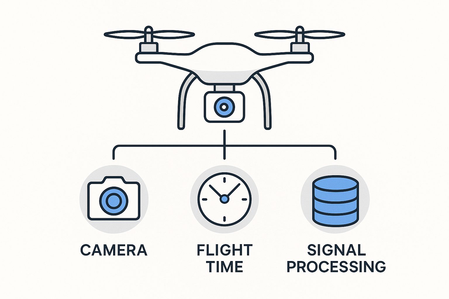
As you can see, these elements are all connected. They build on each other to shape the total project cost.
Service Complexity
The most basic cost driver is simply what you're asking the drone to do. A simple aerial photo of a single-family home for a real estate listing sits on the lower end of the complexity scale. It’s usually one flight, a standard camera, and very little post-processing. Quick and straightforward.
On the other hand, creating a high-resolution 3D model of an entire construction site is a completely different beast. This kind of project involves multiple, automated flights from different heights and angles, capturing thousands of carefully overlapped images. The sheer volume of data and the intense processing power needed to stitch it all into a precise, measurable model puts it at a much higher price point.
Equipment and Technology
Not all drones are created equal, and the gear needed for a job has a huge impact on the cost. For most photography or video projects, a professional-grade drone with a solid RGB camera is the standard.
But specialized jobs demand specialized—and frankly, much more expensive—sensors.
Thermal Imaging: This is what you need for spotting heat loss in buildings, inspecting solar farms, or monitoring electrical substations. A quality thermal camera payload can easily cost over $10,000.
LiDAR (Light Detection and Ranging): This tech uses lasers to build incredibly accurate 3D maps and elevation models. LiDAR is the gold standard for high-precision surveying, but the sensors themselves can run $50,000 or more.
Multispectral Sensors: In agriculture, these are essential for analyzing crop health by capturing light from different, non-visible parts of the spectrum. These specialized sensors also come with a significant price tag.
Any provider using this kind of advanced equipment has to factor those high acquisition and maintenance costs into their pricing model.
Pilot Expertise and Certification
When you hire a professional drone service, you aren't just renting a flying camera. You're paying for the pilot's skill, training, and certification. A certified commercial pilot has gone through intensive training and passed exams to prove they know airspace rules, safety protocols, and what to do in an emergency.
This certification is non-negotiable for any commercial work. An uncertified operator isn't just risking huge fines—they're operating without the professional liability insurance needed to protect you and your property if something goes wrong.
Hiring a certified and insured pilot is your assurance of safety, legality, and professionalism. The slightly higher cost is a small price to pay for peace of mind and knowing the job will be done correctly and safely.
Data and Deliverables
What do you actually need at the end of the day? The type and format of your final deliverables have a major say in the final price.
Raw Footage: Getting the unedited photo and video files straight from the drone is the most budget-friendly option. It requires no post-production work from the provider.
Edited Photos/Video: Professionally color-graded images and a fully edited promotional video require time, creative skill, and editing software, all of which add to the cost.
Actionable Reports: For industrial inspections or agricultural surveys, the real value is in the analysis. A report that pinpoints specific faults on a wind turbine or calculates crop health metrics requires specialized software and an expert's interpretation, making it the most valuable—and therefore most expensive—deliverable.
For example, a highly specialized service like drone spraying has its own unique cost structure. To see how these factors come into play in agriculture, you can check out our detailed look at drone spraying cost per acre.
Risk and Location
Finally, where the drone flies matters. A lot. A flight over a wide-open, empty field is about as low-risk as it gets. The pilot can operate with a huge safety margin and very few restrictions.
Now, picture a flight in the middle of a bustling city. This scenario throws a ton of challenges into the mix:
Airspace Restrictions: Flying near airports or in other controlled airspace requires special authorization from the FAA, which can be a time-consuming application process.
Public Safety: The pilot has to actively manage the risk of flying over people and traffic. This often requires extra safety measures and sometimes a second crew member to act as a spotter.
Obstacles: Weaving a drone around buildings, power lines, and tall trees requires exceptional piloting skill and incredibly detailed flight planning.
This elevated risk and complexity demand more planning, a more experienced pilot, and often, better insurance coverage. As a result, projects in high-risk locations will always have a higher drone service cost than jobs in simple, open areas.
How Drone Service Pricing Varies Across Industries
The cost of hiring a drone service isn't a one-size-fits-all number. It’s a direct reflection of the specific challenges, specialized gear, and professional skills each industry demands. Think of it like a mechanic's shop. You wouldn't expect a simple oil change to cost the same as a full engine rebuild, would you?
In the same way, the drone services cost is shaped by the unique needs of the sector it’s serving. A standard drone might be perfect for capturing stunning real estate photos, but it would be completely useless for inspecting a high-voltage power line.
This is why a real estate gig and an industrial inspection, while both using drones, carry vastly different price tags. Let's break down how pricing is tailored to different industries to give you a much clearer idea of what to expect for your project.
Real Estate Photography and Videography Costs
Real estate was one of the first industries to fully embrace drone technology, so its pricing models are pretty well-established by now. For most residential homes, drone services are a surprisingly affordable marketing tool that delivers a huge impact.
A standard package for a single-family home typically includes:
Basic Aerial Photos: A set of 10-15 high-resolution images that showcase the property, its boundaries, and key exterior features. This is often priced per property, usually falling between $200 and $500.
Cinematic Video Tours: A 1-2 minute professionally edited video that blends aerial shots with ground-level footage for a compelling property tour. This requires more flight time and serious post-production work, pushing costs into the $400 to $1,200 range.
Of course, the scale of the property is a major price driver. A large commercial building, a sprawling apartment complex, or a luxury estate all demand more extensive flight planning and data capture, which naturally increases the final cost.
Construction and Surveying Project Costs
On construction sites, drones have gone from a cool novelty to an indispensable tool for managing progress, enhancing safety, and tracking assets. Here, the pricing is less about one-off beauty shots and more about delivering consistent, actionable data over the life of a project.
A one-time topographic survey to kick off a new project might run anywhere from $1,500 to $3,000, depending on the site's size and complexity. This gives engineers the foundational data they need for planning. However, ongoing monitoring services are where the real value lies.
For construction projects, the true value of drones comes from regular, repeatable flights. A monthly or bi-weekly progress monitoring package, often billed as a retainer, allows stakeholders to track progress, verify work, and manage assets with incredible accuracy.
These recurring services typically cost between $300 and $900 per visit. The deliverable isn't just a folder of photos; it’s often a detailed orthomosaic map or a 3D model that can be laid over the original building plans. It’s a powerful way to get a real return on your investment. You can see what models are popular in this field by exploring the top drones in commercial use for 2025.
Agriculture and Energy Inspection Costs
Agriculture and energy are where drone services get highly specialized, and the costs reflect the advanced tech required. In these fields, the drone acts less like a camera and more like a high-tech scientific instrument.
In Agriculture: Farmers use drones equipped with multispectral or even hyperspectral sensors to monitor crop health. These sensors see light far beyond the visible spectrum, revealing subtle signs of plant stress, disease, or nutrient deficiencies long before a human eye ever could.
Crop Scouting: A basic flight to get a general assessment of a field's condition can cost $50 to $300 per hectare.
Variable-Rate Application Maps: Creating precise maps for targeted fertilizer or pesticide application is a more involved process that requires significant data analysis, often raising the price.
In the Energy Sector: Inspecting assets like wind turbines, solar panels, and power lines is dangerous, slow, and incredibly expensive using traditional methods. Drones armed with high-resolution zoom lenses and thermal cameras can get the job done faster, safer, and with more detail.
Solar Farm Inspection: A full thermal scan to pinpoint faulty panels might be priced per day, often ranging from $1,500 to $4,000.
Wind Turbine Inspection: A detailed blade inspection can cost $1,000 to $2,500 per turbine—a mere fraction of what it costs to send up a rope access team.
To put this all into perspective, let's look at how these services stack up side-by-side.
Comparing Drone Service Costs Across Industries
This table provides a quick overview of how pricing models and typical costs differ based on the specific requirements and complexities of various industries.
Industry | Common Service | Key Pricing Factors | Average Project Cost Range (USD) |
|---|---|---|---|
Real Estate | Aerial Photography & Videography | Property size, number of images/videos, editing complexity | $200 - $1,200 |
Construction | Site Surveying & Progress Monitoring | Site acreage, data frequency (one-off vs. recurring), deliverable type (2D map, 3D model) | $300 - $3,000 |
Agriculture | Crop Health Monitoring & Scouting | Hectares covered, sensor type (RGB, multispectral), level of data analysis | $50 - $300 per hectare |
Energy | Asset Inspection (Turbines, Solar) | Type of asset, sensor requirements (thermal, zoom), risk level, report detail | $1,000 - $4,000 per day/asset |
This industry-specific approach is driving massive efficiencies. For instance, drones have been shown to slash surveying costs in construction by 40–50%, with many projects landing well under $2,000. In agriculture, drone monitoring has cut field assessment costs by as much as 85%.
Understanding these industry nuances is the key to accurately forecasting your drone services cost and truly appreciating the specific value they can bring to your business.
How to Confidently Read Your Drone Service Quote
When a detailed proposal for drone services lands in your inbox, it can feel like you’re trying to decipher a foreign language. Suddenly you're faced with terms like "mobilization fees" and "data processing," and it's easy to get lost in the jargon and lose sight of the bigger picture. But getting a grip on your quote is the single most important step to ensure you get exactly what you need—without any nasty surprises on the final bill.
Think about it like a mechanic's estimate for your car. A trustworthy mechanic will itemize every part, the labor for each step, and any special shop fees. A professional drone quote operates on the same principle, offering total transparency by breaking down the drone services cost into clear, understandable line items.
Deconstructing the Key Line Items
A real pro won't just throw a single number at you. They'll provide an itemized list that shows exactly where your money is going. While the layout might differ from one company to another, there are a few key components you should always look for.
These are the most common line items you’ll run into:
Flight Operations: This is the heart of the quote. It covers the pilot's time on your property and the actual use of the drone. It's typically billed by the hour or as a flat half-day or full-day rate.
Data Processing: This is all the behind-the-scenes work that happens after the drone has landed. It could be editing raw photos, stitching images together to create a 3D model, or analyzing thermal data to generate a report you can actually use.
Mobilization Fee: This fee simply covers the provider's cost for travel time and expenses to get their crew and expensive gear to your site. You'll see this more often for projects located a good distance from the operator's home base.
Permits and Authorizations: If your project is near an airport or in other controlled airspace, this fee covers the administrative legwork required to get the necessary legal green light to fly.
Spotting Red Flags and Green Lights
Learning what to look for is how you quickly separate the seasoned professionals from the weekend warriors. A well-organized quote is a huge green light—it signals a well-run business. A vague one-pager? That's a major red flag.
A professional quote isn't just a bill; it's a statement of work that outlines the entire project from start to finish. It should clearly define the scope, deliverables, and terms to protect both you and the provider.
Here’s what a great quote absolutely must include:
Proof of Insurance: It should state clearly that the company carries sufficient liability insurance and can provide a certificate as proof. No excuses.
Specific Deliverables: Vague promises like "aerial photos" just don't cut it. A good quote will specify the number of photos, the length of a video, or the exact resolution and file format for a 3D model.
Clear Scope of Work: The document should detail the exact location, the proposed flight plan, and the mission's objectives.
On the other hand, be very wary if a quote has:
A Single, Lump-Sum Price: With no breakdown, how do you know what you're actually paying for? You don't.
Hidden or Vague Fees: Any line item for a "service charge" or "miscellaneous fee" without a clear explanation should be questioned immediately.
No Mention of Insurance or Certification: This is the biggest red flag of all. Never, ever hire a drone pilot who can't prove they are FAA-certified and fully insured.
By looking over your quote with this mindset, you can compare different offers intelligently, ask the right questions, and ultimately choose a provider who values transparency and professionalism as much as you do.
How New Technology Is Making Drones More Affordable
If you’ve noticed that drone services cost less than they used to, you're definitely onto something. This isn't a sign of pilots cutting corners or skimping on quality. Instead, it’s the direct result of technology evolving at a breakneck pace, making professional drone operations more powerful and efficient than ever.
Think about how personal computers have evolved. A machine that once filled an entire room and cost a fortune now fits in your pocket and is exponentially more powerful. The drone industry is going through a very similar transformation, driven by smarter software and more automated hardware. These advancements are cleaning up workflows, slashing manual labor, and ultimately passing those savings right on to you.
When you understand where these efficiencies come from, it's easier to see that a lower price tag reflects a maturing, more advanced industry—not a cheaper, less valuable service.
The Power of Automation and AI
Time has always been one of the biggest cost drivers in any service, and drone operations historically required a ton of it. Pilots had to manually plot every single flight path, and data analysts would spend days, even weeks, staring at thousands of images to pull out the useful bits of information. Today, that entire process has been turned on its head.
Modern drone software now automates flight planning with incredible efficiency. For a mapping job, a pilot can just draw a boundary around the area on a tablet, set the altitude and image overlap, and the software instantly cooks up the most efficient flight path. The drone then flies the mission all by itself, capturing data with a level of precision that's tough to match by hand.
This automation doesn't stop when the drone lands, either:
AI-Powered Analysis: Artificial intelligence can now rip through thousands of images, automatically spotting specific objects or problems. For instance, an AI can scan thermal images of a solar farm and flag every bad panel in minutes—a job that used to take a human analyst hours of painstaking work.
Automated Counting: On a busy construction site, software can automatically count material stockpiles or vehicles. This gives project managers inventory data in near real-time, completely hands-off.
Simply put, these automated systems dramatically cut down the hours needed on-site and in the office. By letting the tech handle the repetitive, mind-numbing tasks, human experts can focus on what they do best: high-level analysis, quality control, and interpreting the data to give you real answers.
Cloud Processing and Platform Accessibility
Another absolute game-changer is the rise of cloud-based processing platforms. Not long ago, if you wanted a complex 3D model or a high-resolution orthomosaic map, you needed a beast of a computer workstation that cost thousands of dollars. Even then, the processing could tie up that machine for days on end.
Now, a drone operator can just upload all the raw data to a secure cloud platform. These platforms use massive, distributed computing power to crunch the numbers in a tiny fraction of the time. The final map, model, or report is then delivered back to you through a simple, easy-to-use web link.
The impact here is huge. As the market has grown, technology has brought the cost of getting and processing drone data way down. Basic aerial mapping and inspection packages, which used to be a major expense, now start as low as $500–$2,000 per project. This is all thanks to automation, better software, and simple economies of scale. To give you an idea, automated mapping and volumetric calculations that once took days of manual work can now be done in hours, and processing costs have dropped by nearly 75% in just the last few years. You can dig deeper into these trends in reports on the global drone data services market.
This shift to the cloud has effectively democratized access to high-end data products. It's no longer a service just for massive corporations; it's now a practical and affordable tool for smaller businesses and projects with real-world budgets.
Common Questions About Drone Service Costs
Even with a better understanding of what goes into pricing, you probably still have some practical questions about the final drone services cost. I get it. This section is designed to be a quick, straightforward guide, tackling the most common questions we hear from clients just like you. The goal is to help you move forward with confidence.
Why Is There Such A Wide Price Range?
The huge swing you see in drone service prices directly mirrors the equally huge range of what a project might demand. At the end of the day, the cost is built around the specific tools, talent, and time needed to get your job done right.
Think about it like this: a simple 30-minute real estate photoshoot is pretty routine. It typically requires a standard camera, involves minimal risk, and the data processing afterward is fairly light. That's why it lands on the lower end of the cost scale.
Now, contrast that with a multi-day industrial inspection of something like a power plant. That's a different beast entirely. This kind of job needs specialized thermal sensors, highly certified pilots, complex flight permissions, and hours of intensive data analysis. This massive gap in equipment, expertise, risk, and what's delivered is exactly why the price can vary so dramatically.
Can I Save Money With A Cheaper Pilot?
Hiring an uncertified pilot might look like a savvy way to cut costs on paper, but it's a massive gamble that can end up costing you exponentially more. Certified commercial drone pilots are legally required to carry liability insurance, which is your financial safety net if anything goes wrong.
An accident caused by an uncertified, uninsured operator could leave you on the hook for property damage, hefty legal fees, and even regulatory fines. Those potential costs would absolutely dwarf any money you thought you saved upfront. For your own protection, always verify a provider's certification and insurance status. Our guide on drone business insurance breaks down why this is non-negotiable for both the pilot and the client.
Do Long-Term Contracts Offer Savings?
Absolutely. Most drone service providers are happy to offer significant discounts for bundling services or committing to a long-term contract. For instance, if you know you'll need monthly progress updates for a year-long construction project, setting up a retainer agreement is a fantastic way to lock in a better rate.
Bundling services—like ordering photos, video, and a 3D model all at once—is another smart way to bring down your total cost. Providers can streamline their workflow for a single, multi-faceted project and pass those efficiency savings directly on to you. If you have recurring needs, it never hurts to ask about package deals.
Hey, I actually found this while looking through comments under a YouTube video about posture correction. Someone mentioned https://ways2well.com/blog/regenerative-medicine-for-shoulder-pain-relief, so I opened it in a new tab. I liked that it talked about different causes like overuse and arthritis without lumping everything together. The examples felt realistic, especially the part about everyday movements becoming uncomfortable. It made the topic easier to relate to, and I ended up reading more than I expected.