Top 12 Drone Weather App Choices for Pilots in 2025
- Paul Simmons

- Jul 5, 2025
- 14 min read
Updated: Jul 6, 2025
Every seasoned drone pilot knows the pre-flight ritual: check batteries, inspect propellers, and plan the route. But one step separates a successful mission from a potential disaster: a thorough weather check. Standard weather forecasts often fall short, failing to provide the granular, altitude-specific data crucial for safe UAV operation.
Wind shear, geomagnetic interference (Kp index), and sudden precipitation can ground a flight or, worse, lead to a flyaway. That's why a dedicated drone weather app isn't a luxury; it's an essential component of your digital toolkit, directly solving the problem of inadequate, surface-level weather data. This guide moves beyond simple feature lists to provide a deep analysis of the 12 best apps available, arming you with the information needed to make an informed choice.
We'll dissect each app's accuracy, unique features, pricing, and real-world performance, complete with screenshots and direct links. Whether you're a weekend hobbyist capturing scenic shots or a commercial operator on a critical job, this resource will help you find the perfect drone weather app to ensure every launch is a safe one.
1. AURA - Smart Weather for Drone
AURA distinguishes itself as a premier drone weather app, especially for pilots within the Apple ecosystem. Its core strength lies in translating complex meteorological data into simple, actionable flight readiness indicators. The user-friendly interface presents a clear "Go" or "No Go" status, making it incredibly accessible for beginners while still offering the depth required by seasoned professionals.
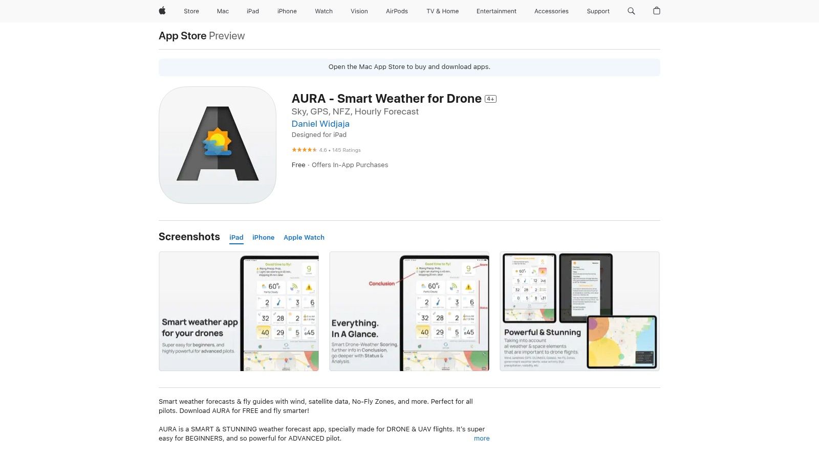
The app goes beyond basic wind speed and precipitation forecasts by integrating crucial drone-specific metrics. It analyzes wind gusts at various altitudes, geomagnetic storm data (Kp index), and visibility, providing a holistic view of flight conditions. Its "Time Travel" feature is a standout, allowing users to scrub through a 5-day forecast to pinpoint the exact optimal window for a future mission, a practical tool for planning commercial shoots or weekend hobby flights.
Key Details & Features
Best For: Hobbyists and professional pilots who primarily use iOS devices and value a streamlined, visually intuitive interface.
Unique Feature: The "Active Weather Scanner" provides real-time alerts for changing conditions, a vital safety net during active flights.
Accessibility: Offers a generous free version that covers most essential needs. An optional "AURA Pro" subscription unlocks advanced features like detailed hourly graphs and expanded forecast ranges.
Platform: Exclusively available on iOS (iPhone, iPad, and Apple Watch).
Link: AURA on the App Store
2. Dronecast - Weather for Drones
Dronecast establishes itself as a highly capable drone weather app by focusing on hyperlocal, real-time data crucial for safe flight operations. It excels at providing detailed pre-flight reports that not only cover standard weather metrics but also highlight potential hazards. The app's interface is clean and data-rich, presenting pilots with critical information without feeling overwhelming, making it a strong contender for those who need comprehensive planning tools.
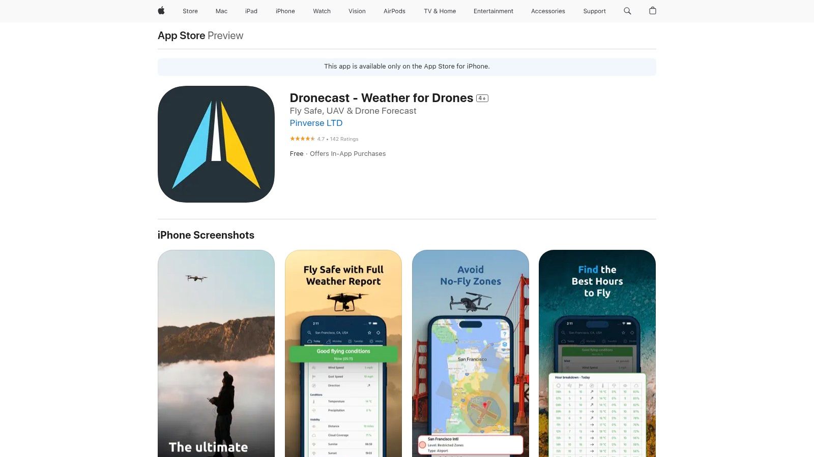
A key differentiator for Dronecast is its integration of No-Fly Zone maps and official flying advisories directly within the weather dashboard. This feature saves pilots the extra step of consulting separate apps for airspace restrictions. Furthermore, its ability to display wind and gust speeds at various altitudes allows for more precise risk assessment, especially when operating drones at higher elevations. The ad-free experience, even in the free version, is a welcome benefit for focused pre-flight checks.
Key Details & Features
Best For: Pilots who require integrated airspace advisories alongside detailed, hyperlocal weather data for meticulous mission planning.
Unique Feature: The combination of minute-by-minute hyperlocal forecasts with built-in No-Fly Zone maps provides a one-stop-shop for flight readiness.
Accessibility: Offers a functional free version with an ad-free experience. A premium subscription is available to unlock the full 7-day hourly forecast and other advanced features.
Platform: Exclusively available on iOS.
3. UAV Forecast
UAV Forecast stands as one of the most established and trusted names in the drone weather app space, renowned for its comprehensive data and cross-platform availability. It excels at providing pilots with a detailed yet digestible dashboard of flight conditions. The app presents critical information through configurable parameters, allowing users to set their own thresholds for wind speed, temperature, and precipitation, which then informs a clear "Good to Fly?" or "Not Good to Fly" recommendation.
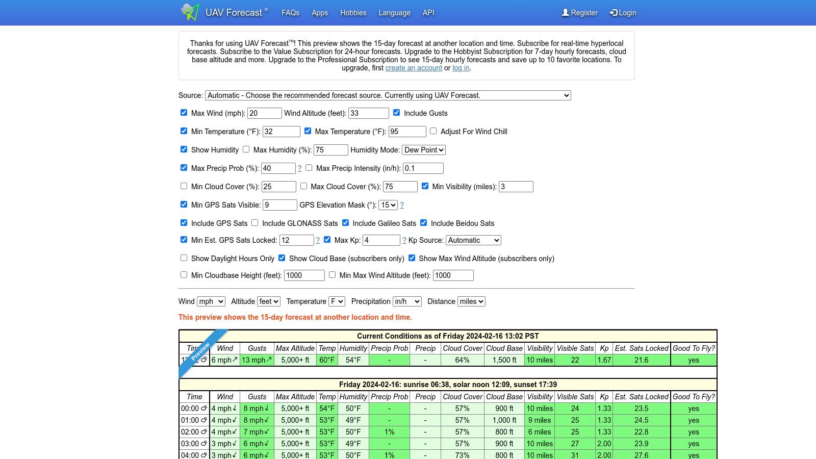
What sets UAV Forecast apart is its detailed breakdown of wind speed at various altitudes, a critical factor often overlooked by generic weather services. Pilots can see a visual representation of how wind conditions change as the drone ascends, which is invaluable for mission planning. This level of detail, combined with data on GPS satellite visibility (K-Index) and cloud cover, makes it an indispensable tool for ensuring both safety and optimal photo/video quality. It also integrates well with broader operational workflows; in fact, its data is often used in combination with top drone flight planning software picks to ensure mission success from start to finish.
Key Details & Features
Best For: Pilots of all levels who need reliable, detailed weather data and operate across different devices (web, Android, iOS).
Unique Feature: Its highly customizable flight parameter rules allow users to tailor the "Go/No Go" alerts to the specific limits of their drone model.
Accessibility: A robust free version provides 24 hours of forecasts. The paid subscription unlocks up to 7 days of detailed hourly forecasts, weather maps, and more advanced features.
Platform: Available on the Web, Android, and iOS.
Link: UAV Forecast
4. Drone Buddy
Drone Buddy carves out a unique space in the crowded drone weather app market by integrating a powerful community aspect with its core meteorological data. While it provides essential real-time information on wind, weather, and the Kp index, its standout feature is the crowd-sourced map of flying spots. This transforms it from a simple data provider into a social tool for discovering and sharing safe, scenic, and legally-permissible flight locations.
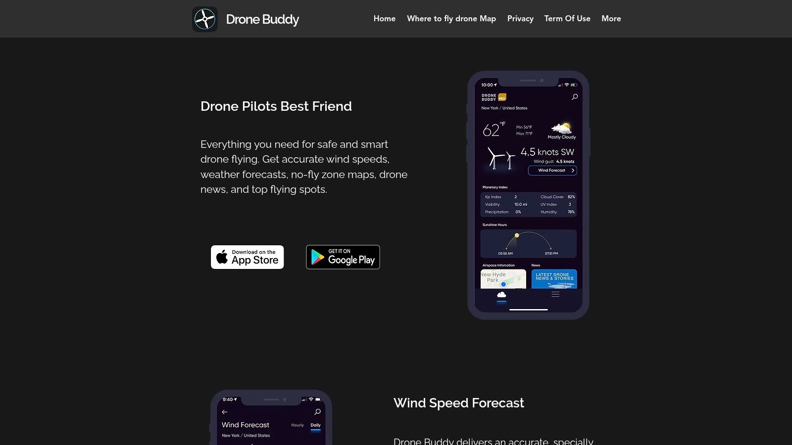
The app presents a clean, easy-to-read interface that displays critical flight data like wind speed, gustiness, and sunrise/sunset times. It also includes integrated No-Fly Zone maps, helping pilots maintain regulatory compliance. The blend of reliable weather forecasting with community-driven insights makes Drone Buddy a highly practical tool for both pre-flight planning and discovering new areas to explore with your drone.
Key Details & Features
Best For: Pilots who value community input and want to discover new, pilot-verified flying locations alongside standard weather checks.
Unique Feature: A community-powered map that allows users to share and find drone-friendly flying spots, complete with user photos and comments.
Accessibility: A capable free version is available, with a "Pro" subscription required to unlock advanced features like detailed hourly wind charts and expanded map functionalities.
Platform: Available on both iOS and Android.
Link: dronebuddy.io
5. Windy
Windy is less a dedicated drone weather app and more a comprehensive meteorological powerhouse that savvy drone pilots have adopted for its sheer depth of data. While it doesn't offer a simple "Go/No Go" drone-specific signal, its strength lies in providing unparalleled detail through multiple forecast models (ECMWF, GFS, etc.). This allows pilots to compare predictions and gain a more nuanced understanding of potential conditions, from ground level to high altitudes.
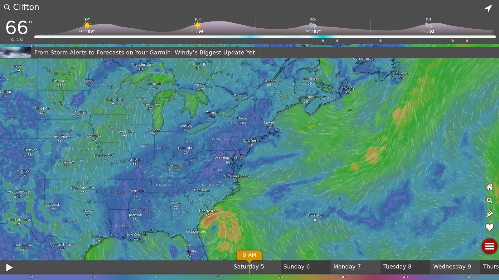
The platform truly shines with its interactive map and extensive weather layers. Users can visualize wind patterns, gusts, cloud cover, visibility, and even atmospheric pressure with incredible granularity. For commercial operators planning flights in complex terrain or remote locations, the ability to drop a pin anywhere and get a detailed forecast is invaluable. It requires more interpretation than drone-centric apps, but for pilots who want to be their own meteorologist, Windy is an essential tool.
Key Details & Features
Best For: Experienced and professional pilots who are comfortable interpreting raw weather data and want the most comprehensive view possible.
Unique Feature: The ability to compare different leading weather forecast models side-by-side for the same location, offering a consensus or highlighting forecast uncertainty.
Accessibility: The core features are completely free to use. An optional premium subscription provides higher-resolution forecasts and more frequent updates.
Platform: Available as a powerful website and on both iOS and Android.
Link: windy.com
6. Kittyhawk (now Aloft)
Evolving from the well-regarded Kittyhawk, Aloft positions itself as far more than just a drone weather app; it's a comprehensive command center for professional drone operations. While it provides detailed weather data, including wind speed, direction, and visibility, its primary strength lies in integrating this information with a full suite of compliance and fleet management tools. This makes it an indispensable asset for commercial pilots who need to manage missions, log flights, and ensure regulatory adherence in one unified platform.

Aloft’s platform excels at providing real-time airspace intelligence, including live traffic alerts and instant LAANC authorizations for flights in controlled airspace. The pre-flight risk assessment checklist is a standout feature, systematically guiding pilots through safety checks that incorporate current and forecasted weather conditions. This integrated approach ensures that weather is not just a standalone metric but a core component of a safe and compliant flight plan, a crucial distinction for professional use cases. You can explore a deep dive into its situational awareness capabilities to understand its new era of drone safety.
Key Details & Features
Best For: Commercial operators, enterprise fleets, and professional pilots who require an all-in-one solution for compliance, logging, and mission planning.
Unique Feature: Integrated LAANC (Low Altitude Authorization and Notification Capability) allows for near-instant FAA approval for flights in controlled airspace directly within the app.
Accessibility: Offers a free tier with core functionalities like LAANC and flight logging. Advanced features such as fleet management and in-depth analytics are available through paid subscription plans.
Platform: Available on Web, iOS, and Android.
Link: Aloft Website
7. AirMap
AirMap is a comprehensive flight management platform that extends beyond typical weather forecasting to focus heavily on airspace safety and regulatory compliance. While many apps tell you if the weather is safe, AirMap tells you if the airspace is legal, making it an indispensable tool for pilots operating in or near controlled areas. It provides real-time geofencing alerts and detailed maps of advisories, temporary flight restrictions (TFRs), and no-fly zones.
The platform's primary strength is its direct integration with aviation authorities, allowing for Low Altitude Authorization and Notification Capability (LAANC) requests directly within the app. This feature is a game-changer for commercial operators needing quick, automated approval to fly in controlled airspace. While it incorporates basic weather data, its core value is as an airspace intelligence and compliance engine, not just a standalone drone weather app. The interface can feel dense for new users, but its power for ensuring safe and legal flights is unmatched.
Key Details & Features
Best For: Commercial drone pilots and serious hobbyists who frequently operate near airports or in regulated airspace.
Unique Feature: Integrated LAANC authorizations for instant flight plan approvals in controlled airspace in supported countries.
Accessibility: The core app is free to use. Advanced features and enterprise solutions are available through various subscription tiers.
Platform: Available on Web, iOS, and Android.
Link: www.airmap.com
8. Drone Assist
Drone Assist, powered by Altitude Angel, carves out a unique niche by focusing on situational awareness and regulatory compliance rather than just meteorological data. It’s less of a traditional weather forecaster and more of a comprehensive flight safety tool. The platform excels at providing an interactive map that clearly delineates No-Fly Zones, ground hazards, and other potential airspace restrictions, making pre-flight checks straightforward and thorough.
While it doesn't offer the granular wind-at-altitude graphs of a dedicated drone weather app, its value lies in integrating crucial safety information into one view. Pilots can see real-time alerts for temporary flight restrictions or hazards reported by other users. Its standout feature is the ability to submit flight plans and even request digital access approval for flying in certain restricted zones, a critical function for commercial operators working near airports or in controlled airspace. It's an indispensable co-pilot for ensuring every flight is safe and fully compliant with local aviation rules.
Key Details & Features
Best For: Commercial and hobbyist pilots who prioritize airspace safety, legal compliance, and situational awareness over detailed meteorological forecasts.
Unique Feature: The built-in "Approval Services" allow pilots to request flight authorization directly through the app for certain restricted airspaces, streamlining a complex process.
Accessibility: The core application and its primary safety features are completely free to use.
Platform: Available on iOS and Android.
Link: Drone Assist by Altitude Angel
9. Hover
Hover positions itself as an excellent all-in-one flight readiness tool rather than a dedicated, complex drone weather app. Its primary strength is integrating essential pre-flight data streams, combining real-time weather with crucial airspace information. This allows pilots to quickly assess both meteorological and regulatory safety factors from a single, clean interface, making it a highly efficient first stop before any flight.
The app provides core weather metrics like temperature, wind speed, and cloud cover, presented in an easy-to-digest format. However, its standout value comes from the inclusion of No-Fly Zone maps, which are overlaid with your current location. This dual-data approach helps pilots avoid both bad weather and restricted airspace simultaneously. The addition of a flight logging tool and a drone-related news feed further solidifies its place as a practical hub for the everyday pilot.
Key Details & Features
Best For: New pilots and hobbyists who want a simple, free tool that covers the absolute basics of weather and airspace in one place.
Unique Feature: The combination of weather data and No-Fly Zone maps in a single, uncluttered view. This simplifies the pre-flight check process significantly, a key part of any drone pre-flight checklist.
Accessibility: Completely free to use, making it highly accessible for pilots on any budget.
Platform: Available on both iOS and Android.
Link: Hover Website
10. B4UFLY
While primarily an airspace safety tool, B4UFLY is an indispensable app for any drone pilot in the United States, earning its spot through its focus on regulatory compliance. Developed in partnership with the FAA, its main function is to provide real-time airspace status on interactive maps. It clearly shows where you can and cannot fly, detailing restrictions around airports, national parks, and temporary flight restrictions (TFRs). This direct line to official FAA data makes it an authoritative source for legal flight planning.
Although it is not a dedicated drone weather app, its role in pre-flight checks is critical. Before you even check the wind speed or Kp index on another app, you must first confirm your flight is legal. B4UFLY streamlines this process, allowing pilots to confidently assess a location's viability from a regulatory standpoint. For a comprehensive pre-flight routine, pilots should use B4UFLY for airspace authorization first, then consult a specialized weather app for atmospheric conditions.
Key Details & Features
Best For: All U.S.-based drone pilots, from hobbyists to commercial operators, who need to ensure FAA airspace compliance.
Unique Feature: As the FAA's official app, it provides the most authoritative and up-to-date information on controlled airspace, TFRs, and other flight restrictions.
Accessibility: Completely free to download and use, with no subscriptions or hidden costs. For more information, you can learn more about the B4UFLY app.
Platform: Available on iOS and Android, as well as a desktop web version.
Link: B4UFLY Official FAA Page
11. MyRadar
While not exclusively a drone weather app, MyRadar has earned its place on this list due to its powerful, high-definition animated weather radar and comprehensive aviation data. It excels at providing pilots with a real-time, visual understanding of precipitation and storm systems moving through an area. For drone operators, this means unparalleled situational awareness for avoiding pop-up showers or assessing the movement of larger weather fronts that could ground a mission.
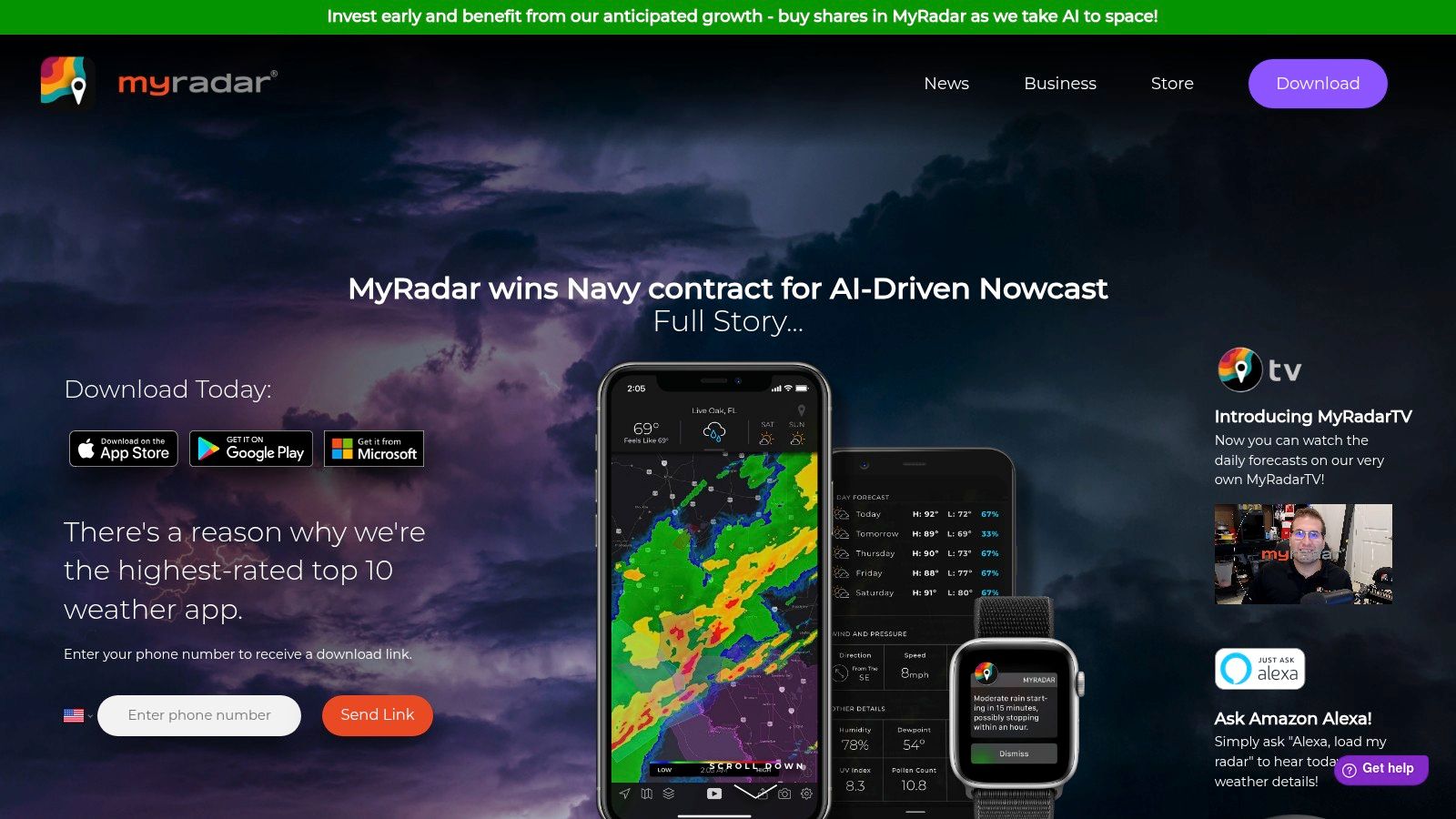
The app’s strength lies in its layers. Pilots can overlay aviation-specific information, like AIRMETs (Airmen's Meteorological Information) and SIGMETs (Significant Meteorological Information), which are crucial for understanding broader atmospheric hazards. While it requires more interpretation than a dedicated drone app, its raw data accuracy is top-tier for making informed, safety-critical decisions before and during a flight. The hurricane tracker and severe weather alerts are also invaluable for operators in volatile climates.
Key Details & Features
Best For: Pilots who are comfortable interpreting standard aviation weather data and prioritize real-time, high-resolution radar imagery over simplified drone-specific metrics.
Unique Feature: The optional "Aviation Layers" pack provides professional-grade overlays like IFR/VFR routes and real-time flight tracking, giving a comprehensive view of the airspace.
Accessibility: The core radar and alert functions are completely free. Advanced features like the aviation layers are available through an in-app purchase.
Platform: Available on iOS, Android, and Windows.
Link: myradar.com
12. WeatherBug
While not a dedicated drone weather app, WeatherBug has earned its place on this list due to its powerful, hyper-local forecasting and real-time lightning detection network. It functions as a robust general weather tool that, with a little interpretation, provides drone pilots with highly accurate, ground-level data crucial for pre-flight checks. Its strength lies in its vast network of proprietary weather stations, delivering live conditions that are often more granular and current than standard forecast models.
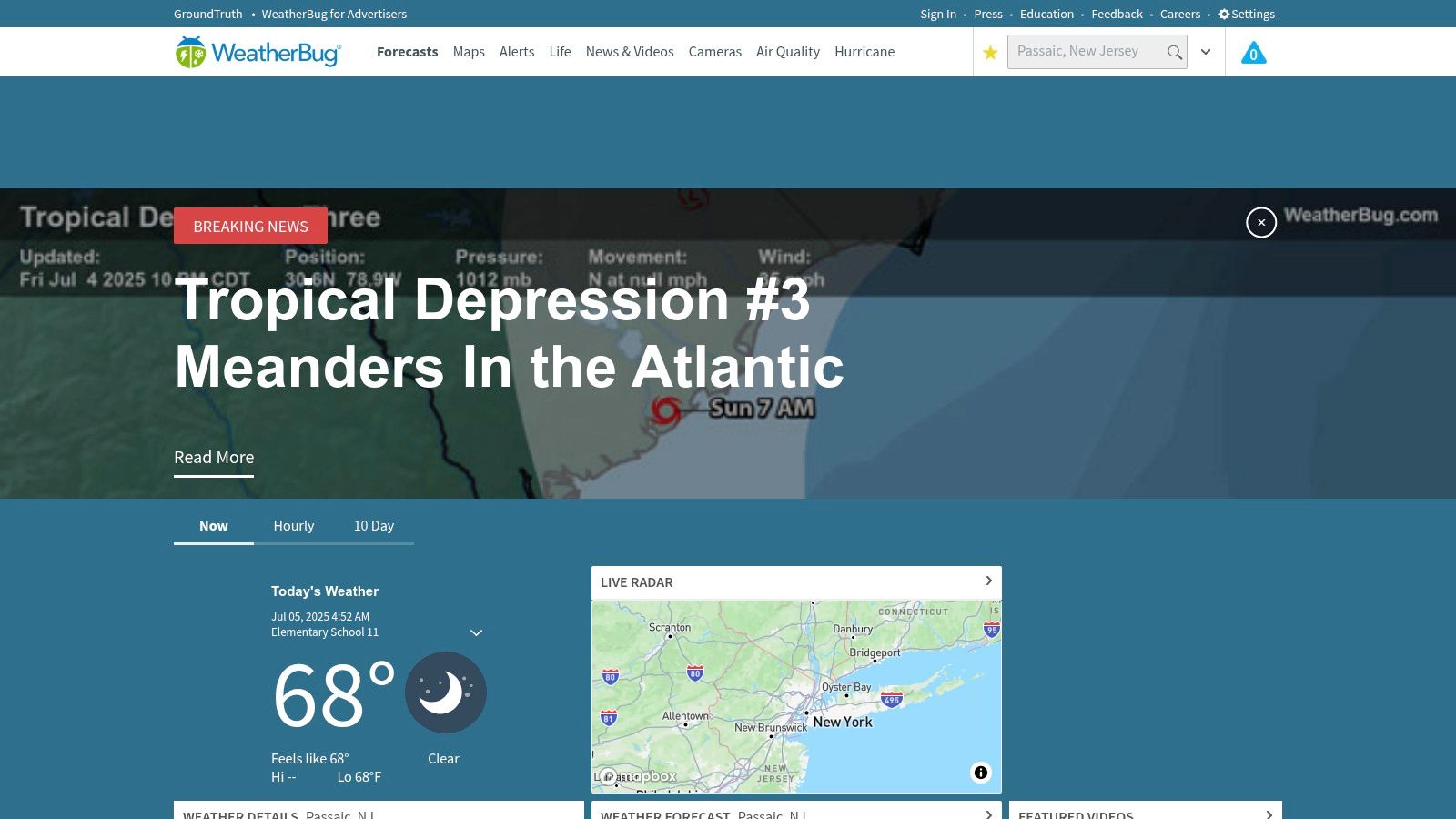
For drone operators, the most compelling feature is the Spark™ Lightning Alert system. It provides minute-by-minute, mile-by-mile lightning strike information, offering a critical safety layer that many drone-specific apps lack. Pilots can use the live radar maps to track precipitation cells and wind patterns, making informed decisions about launching, landing, or avoiding certain areas. While it requires you to translate raw data like wind speed into flight viability yourself, the quality and immediacy of that data are top-tier.
Key Details & Features
Best For: Pilots who want a comprehensive, all-purpose weather app and are comfortable interpreting raw meteorological data for flight safety.
Unique Feature: The Spark™ Lightning Alert system offers real-time, highly localized lightning detection, a significant safety advantage for any outdoor operation.
Accessibility: The core features are available for free with ad support. A premium subscription is available to remove ads and unlock additional map layers.
Platform: Available on iOS, Android, and as a web platform.
Link: WeatherBug Website
Drone Weather Apps Feature Comparison
App / Platform | Core Features ✨ | User Experience ★★★★☆ | Value Proposition 💰 | Target Audience 👥 | Unique Selling Points 🏆 | Price Points 💰 |
|---|---|---|---|---|---|---|
AURA - Smart Weather | Hourly 5-day drone weather, No-Fly Zones, Time Travel | Friendly for beginners & advanced pilots | Free version with solid features | Recreational & pro pilots | Smart weather analysis, color blindness support | Free + subscription |
Dronecast | Real-time hyperlocal weather, wind/gust altitudes | Customizable for drone models, ad-free | Safe flight planning, detailed data | Drone pilots needing accuracy | Minute-updated forecasts, hazard alerts | Subscription-based |
UAV Forecast | Wind/cloud/visibility/GPS status, geomagnetic KP | Good-to-Fly indicators, multiplatform | Comprehensive drone weather data | All drone pilots | KP geomagnetic index, multi-altitude data | Free + subscription |
Drone Buddy | Wind, precipitation, No-Fly Zones, community spots | User-friendly, iOS & Android support | Community-driven, accessible | Hobbyists & community users | Drone-friendly location sharing | Free + Pro subscription |
Windy | Multiple weather models, satellite imagery | Extensive data but not drone-specific | Free, detailed environmental data | Advanced users & pros | High-res satellite, customizable spots | Free |
Kittyhawk (Aloft) | Airspace intel, flight planning, compliance tools | Comprehensive, multiplatform | Enterprise-grade operations | Professionals & enterprises | LAANC, fleet mgmt, risk assessments | Subscription-based |
AirMap | Airspace maps, flight plan submissions, approvals | Regulatory, multiplatform | Streamlined legal compliance | Commercial & hobby pilots | Auto approvals, pilot community | Subscription-based |
Drone Assist | Maps w/ hazards, flight sharing, approvals | Comprehensive & free | Safety and compliance focus | Recreational & pros | Integrated hazard info, free use | Free |
Hover | Weather + airspace, flight log, news | Simple, combined data | Easy drone safety checks | Beginners & casual pilots | Clean UI, combined weather & airspace | Free |
B4UFLY | FAA official airspace status, interactive maps | Official & regulatory focused | Ensures legal compliance | US drone pilots | FAA-backed, educational resources | Free |
MyRadar | Radar imagery, severe weather alerts | User-friendly but not drone-specific | Real-time weather updates | General pilots & users | High-def radar, hurricane tracking | Free |
WeatherBug | Real-time weather, lightning detection | Easy to use, generic weather app | Current weather awareness | General pilots & public | Lightning alerts, live radar | Free |
Choosing Your Perfect Flight Companion: Final Recommendations
Navigating the crowded marketplace for a reliable drone weather app can feel as complex as interpreting a multi-layered atmospheric forecast. Throughout this guide, we've dissected twelve of the top contenders, from specialized powerhouses like UAV Forecast and Dronecast to comprehensive meteorological platforms like Windy and MyRadar. The core takeaway is clear: the "best" app is not a one-size-fits-all solution, but rather the tool that aligns most closely with your specific mission parameters, risk tolerance, and workflow.
Your journey to selecting the perfect flight companion should begin with a candid self-assessment. Are you a weekend hobbyist capturing stunning landscapes, or a certified professional conducting critical infrastructure inspections? The answer dramatically shapes your needs.
Key Considerations for Your Final Decision
To help you make an informed choice, let's distill our findings into a final checklist of considerations:
Pilot Profile: A hobbyist’s needs are well-served by free, user-friendly apps like Drone Buddy or Hover, which provide essential go/no-go signals. In contrast, commercial operators require the granular data, logging features, and compliance integrations found in premium services like Aloft (formerly Kittyhawk) or UAV Forecast.
Data Specificity: Do you need basic wind speed, or do you require wind data at multiple altitudes? Is a general cloud cover percentage sufficient, or do you need to know the specific cloud base height to avoid punching into IFR conditions? Specialized apps excel at drone-centric metrics like the Kp index, which is often absent in general weather apps.
The "Two-App" Strategy: A common practice among veteran pilots is to use a combination of tools. You might use a dedicated drone weather app like AURA for your primary pre-flight check, then cross-reference its wind forecast with the visual models in Windy to understand the broader weather patterns affecting your flight zone. This layered approach provides redundancy and builds a more complete operational picture.
Integration and Workflow: Consider how an app fits into your existing pre-flight checklist. Do you need an all-in-one solution that includes LAANC authorization and flight logging like Aloft, or are you simply looking for a standalone weather tool to supplement your current process? A streamlined workflow saves time and reduces the chance of overlooking critical safety checks.
Ultimately, the goal of any drone weather app is to empower you to make safer, more informed decisions. The data these tools provide transforms you from a reactive pilot, who might be surprised by a sudden gust, to a proactive mission commander, who anticipates conditions and plans accordingly. We encourage you to download two or three options from this list that resonate with your needs. Test their interfaces, compare their forecasts for your local area, and see which one feels most intuitive. The small investment in time will pay significant dividends in safety, confidence, and the quality of your aerial captures. With the right data in your palm, you are not just launching a drone; you are mastering the skies.
Ready to elevate your flying from a hobby to an art form? At JAB Drone, we provide in-depth tutorials, gear reviews, and advanced guides that go beyond the basics. Explore our resources at JAB Drone to master everything from cinematic flight techniques to post-production workflows.
Comments