Your Guide to BVLOS Drone Operations
- Paul Simmons

- Jul 25, 2025
- 18 min read
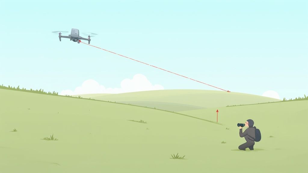
For ages, drone pilots have been bound by one simple rule: if you can't see it, you can't fly it. This is known as Visual Line of Sight (VLOS). But what happens when you need to inspect miles of pipeline, deliver a package to a remote village, or survey a massive farm? That's where BVLOS comes in.
A BVLOS (Beyond Visual Line of Sight) drone is an aircraft flown far beyond the pilot's direct eyesight, opening up a world of possibilities for long-distance missions like delivery, large-scale inspection, and mapping. This is a massive leap from traditional drone flights, which are fundamentally limited by how far the human eye can see.
Expanding the Horizon: The Real Potential of BVLOS
Think about the difference between navigating with a local street map versus a global satellite GPS. That’s the kind of jump we’re talking about when moving from standard drone flying to BVLOS operations. This isn't just about flying farther—it's about completely rethinking what drones are capable of.
When a drone can cover vast distances, it unlocks incredible efficiency and scale. This is why industries from logistics and agriculture to public safety are on the cusp of a major transformation, all driven by this one technology.
From Visual Tether to Autonomous Operations
A standard drone flight is like having the aircraft on an invisible leash, tied directly to the pilot’s eyes. BVLOS effectively cuts that leash. In its place is a robust, high-tech connection that allows the drone to carry out complex jobs many miles away. Naturally, this demands a completely different mindset for flight planning, safety protocols, and the tech itself.
The next wave of BVLOS will lean heavily on breakthroughs in intelligent autonomy and even emerging fields like Agentic AI. These sophisticated systems allow drones to make smart, real-time decisions on their own, without a human needing to intervene for every little course correction.
Here’s where BVLOS is already creating massive value:
Large-Scale Infrastructure Inspection: Imagine safely inspecting hundreds of miles of power lines, pipelines, or railways without ever sending a crew into the field.
Automated Logistics and Delivery: This is how you create aerial highways for delivering medical supplies, packages, and critical goods to remote or disaster-stricken areas.
Precision Agriculture at Scale: Surveying enormous farms to check on crop health, manage irrigation, and boost yields with a level of detail that was once pure science fiction.
Public Safety and Emergency Response: Covering huge search areas in rescue missions or getting a bird's-eye view over large-scale incidents like wildfires.
What This Guide Will Cover
To successfully fly in this new frontier, you need a solid grasp of several core concepts. We're going to break down the key pillars that support every successful BVLOS mission.
The heart of BVLOS isn't just about distance; it's about trust. Trust in the technology to perform, trust in the regulations to keep everyone safe, and trust in the operator to execute the mission flawlessly. Building that trust is the real key to unlocking the future of unmanned aviation.
This guide will give you a complete walkthrough of what it really takes to fly beyond sight. We’ll dissect the complex regulatory landscape and detail the requirements you’ll need to meet. We'll also break down the essential tech that powers these flights—from communication links to ground control stations. Finally, we’ll cover safe operational planning and show off some of the groundbreaking applications already changing our world.
Navigating BVLOS Drone Regulations
For anyone looking to get into BVLOS drone operations, the biggest hurdle isn't the tech—it's the tangled web of regulations. Flying a drone beyond where you can see it means you're entering shared airspace, and authorities like the FAA in the U.S. or EASA in Europe have laid out strict rules to keep everyone safe.
Instead of just giving you a dry list of rules, let's get to the heart of why they exist. The main goal behind every regulation is to manage risk and maintain a level of safety on par with manned aviation. Think of it less like a set of restrictions and more like a safety blueprint for flying powerful aircraft from a distance.
This entire blueprint is built on one thing: proving your operation won't be a danger to people on the ground or other aircraft in the sky.
The Foundation of Airspace Safety
At its core, the BVLOS approval process boils down to one simple question: "How can you prove your flight will be safe?" Answering that takes a comprehensive approach, hitting on three key areas that regulators care about most.
Airworthiness: Your drone has to be exceptionally reliable. This means proving the aircraft is built to high standards, has backup systems for potential failures (like a second flight controller or power source), and can handle the stress of flying long distances.
Pilot Competency: The remote pilot in command (RPIC) is far more than a casual hobbyist. Regulators demand extensive training, tough testing, and a deep knowledge of aviation principles, weather patterns, and emergency protocols.
Operational Risk Assessment: You have to meticulously plan every single part of the flight to pinpoint and minimize potential dangers. This is where formal risk assessment models come into play.
A framework used across the globe is the SORA (Specific Operations Risk Assessment). It gives operators a standardized way to analyze the risks of a BVLOS mission and figure out the safety measures needed to make it acceptable. It’s a methodical process for showing regulators you've thought of everything.
Detect and Avoid: The Digital Eyes of a BVLOS Drone
How does a pilot sitting miles away stop their drone from hitting another aircraft? This is probably the most critical question in BVLOS flight, and the answer is Detect and Avoid (DAA) systems.
A DAA system is like the drone's digital eyes and ears, constantly scanning the sky for other traffic. It isn't just one piece of hardware; it's a whole suite of technologies working together to create a protective bubble around the drone.
Key Takeaway: A robust Detect and Avoid system is non-negotiable for getting regulatory approval. It's the cornerstone technology that allows an unmanned aircraft to safely share the sky with traditional planes and helicopters.
This system needs to spot both "cooperative" aircraft (those broadcasting their position with transponders like ADS-B) and "non-cooperative" ones (like a small glider with no transponder). This is usually done with a mix of sensors, like onboard radar, and smart software that can predict flight paths and automatically trigger avoidance maneuvers.
Earning the Right to Fly Far
At the end of the day, getting the green light for a BVLOS operation is all about evidence. Operators must present regulators with a solid safety case, proving through data, testing, and detailed documentation that their tech, procedures, and team meet the highest safety standards. The path can be demanding, but it’s there to keep the skies safe for everyone.
Since rules can change dramatically from one place to another, it's vital to know the specific requirements for your area. For a bigger picture, you can explore our comprehensive guide to understanding drone regulations, which breaks down rules in different countries. Getting that foundational knowledge is the first real step toward launching your own compliant and successful BVLOS operations.
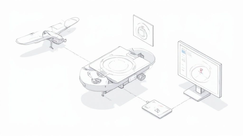
The Tech Stack Powering BVLOS Drone Flights
A successful BVLOS drone operation isn't just about having a great pilot and a solid aircraft. It’s really a complex ecosystem where every piece of hardware and software has to work together flawlessly. Think of it like a scaled-down version of mission control for a space launch—every single component is critical for a safe flight, especially when the drone is hundreds of miles away.
This integrated tech stack is what truly separates a hobbyist drone from a professional-grade BVLOS platform. It’s a marriage of rugged, endurance-focused hardware and intelligent software that acts as the mission's brain. Let's pull back the curtain on the key components that make it all possible.
This technological leap is driving massive growth. The Autonomous Beyond Visual Line of Sight (BVLOS) drone market is exploding, with predictions it will hit around $1.06 billion by 2025. This isn't a fluke; it's supported by a robust compound annual growth rate (CAGR) of 23.26% expected from 2025 to 2033.
The Drone Platform Itself
The aircraft at the heart of a BVLOS drone mission is a different breed entirely. You won't find these on a store shelf. They are purpose-built for flying long distances for extended periods, which often means fixed-wing designs or hybrid VTOL (Vertical Takeoff and Landing) models that combine the best of both worlds.
Here’s what sets them apart:
Redundant Systems: There’s no room for error. Key components like flight controllers, GPS units, and power systems all have backups ready to take over in a split second if a primary system fails.
High-Endurance Power: We're talking massive lithium-ion battery packs or even gas-electric hybrid engines designed to keep the drone in the air for hours, not minutes.
Weather Resistance: These aircraft are engineered to handle the real world, including the wind and rain you're bound to encounter on long flights.
To truly operate on its own and make smart decisions in real-time, a BVLOS drone depends on the integral role of AI, IoT, and edge computing. This onboard intelligence lets the drone process data and react instantly without needing to phone home to the ground station for every little thing.
Command and Control (C2) Links
The Command and Control (C2) link is the invisible lifeline connecting the pilot to the drone. For BVLOS flights, your standard radio connection simply doesn’t have the range or reliability. This link has to be incredibly strong, secure, and capable of working over huge distances.
Key Insight: Losing the C2 link during a BVLOS mission is a major emergency. The entire tech stack is designed to prevent this from happening and to execute foolproof backup plans if it ever does.
To maintain this crucial connection, operators use advanced communication technologies. The right choice depends on where the mission is, how much data needs to be sent, and the budget. As we'll see, each option comes with its own set of pros and cons.
The infographic below really puts the operational leap from traditional VLOS to advanced BVLOS into perspective.
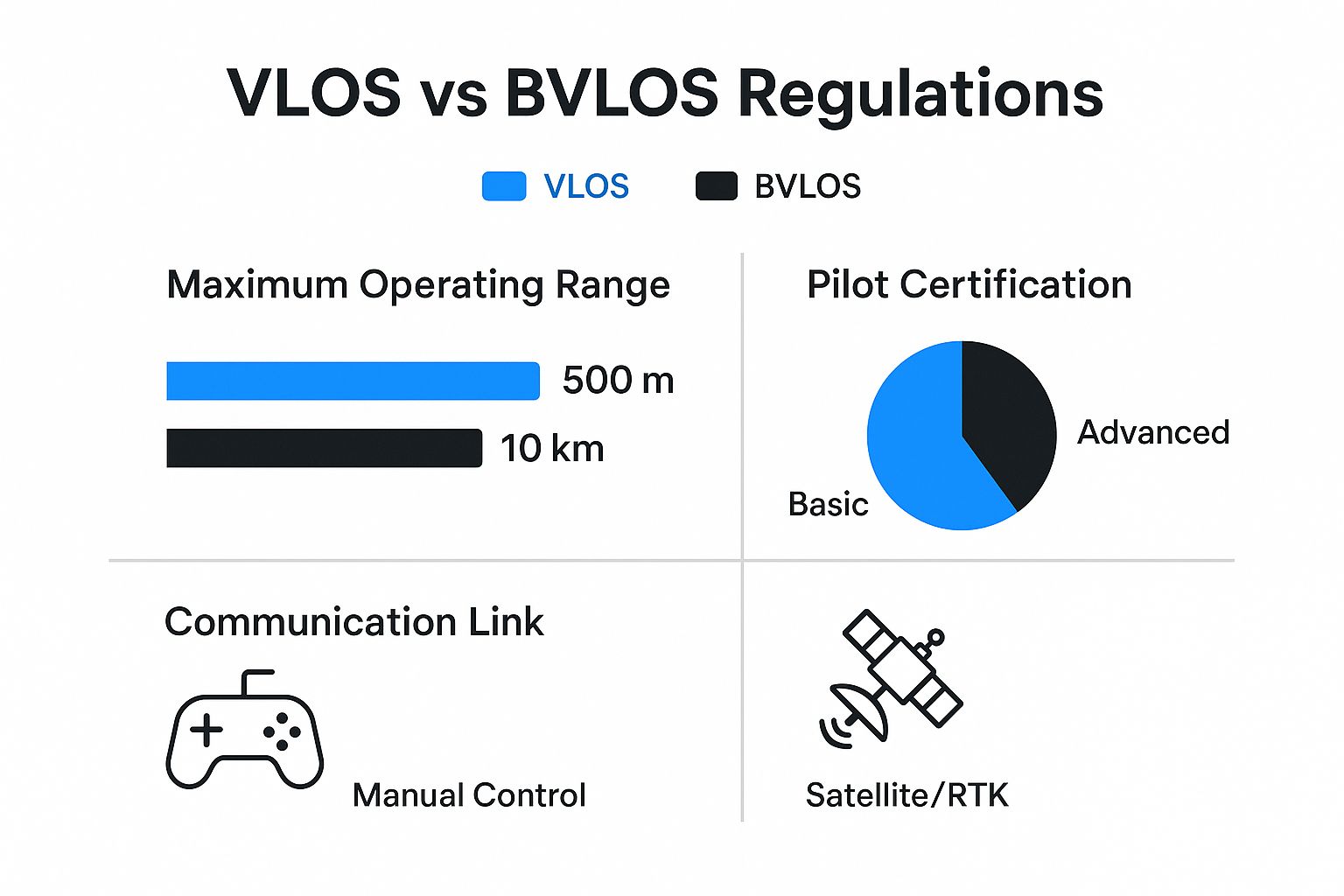
It's clear that going BVLOS isn't just about flying farther—it's a whole new level of operational complexity, pilot qualification, and technological reliance.
To understand the options, let’s compare the primary communication technologies used for BVLOS command and control.
Comparison of BVLOS Command and Control (C2) Link Technologies
Technology | Typical Range | Bandwidth | Pros | Cons | Ideal Use Case |
|---|---|---|---|---|---|
RF Data Links (UHF/VHF) | 5-50 km | Low | Reliable, good penetration, low cost. | Limited range, low data rate for video. | Short-range industrial or agricultural missions. |
4G/5G Cellular | Wherever there's coverage | High | High bandwidth, leverages existing infrastructure, cost-effective. | Reliant on network coverage, potential for latency. | Urban/suburban delivery, linear infrastructure inspection. |
Satellite (SATCOM) | Global | Low-Medium | Near-global coverage, very reliable. | High latency, very expensive hardware and data plans. | Remote maritime, environmental monitoring, or military ops. |
Mesh Networks | Varies (extensible) | Medium | Self-healing, robust, good for swarm operations. | Complex setup, range depends on node density. | Public safety, security patrols, drone swarms. |
Each of these technologies offers a unique balance of capabilities. Selecting the right C2 link is a foundational decision that directly impacts mission safety, cost, and the type of data you can collect.
Detect and Avoid (DAA) Systems
As we’ve mentioned, Detect and Avoid (DAA) is the absolute cornerstone of BVLOS safety. This is the drone's onboard sensory system—its digital eyes and ears—that prevents it from colliding with other aircraft in the sky. It creates a 360-degree awareness bubble around the BVLOS drone.
Common DAA technologies include:
ADS-B (Automatic Dependent Surveillance-Broadcast): This is a receiver that "listens" for signals broadcast by manned aircraft, giving the drone a clear picture of cooperative air traffic.
Onboard Radar/LiDAR: These are active sensors that scan the airspace for anything that isn't broadcasting a signal, like gliders, hot air balloons, or other drones.
Acoustic Sensors: In some setups, highly sensitive microphones can actually detect the sound of an approaching aircraft's engine.
All this data gets crunched by an onboard computer, which uses smart algorithms to spot collision risks and can automatically tell the drone to get out of the way.
The Ground Control Station (GCS)
The Ground Control Station (GCS) is the pilot's command center. It’s so much more than a simple controller with a screen. A professional GCS is a powerful software suite that gives the remote pilot total awareness of the mission and the environment.
From the GCS, a pilot can:
Watch real-time video feeds and monitor critical data like altitude, speed, and battery life.
See the drone’s location on a map, overlaid with data from the DAA system showing other aircraft.
Change the mission plan in the middle of a flight.
Take over manual control or trigger pre-programmed emergency maneuvers if needed.
These four pillars—the aircraft platform, the C2 link, the DAA system, and the GCS—are the technological foundation that makes safe and productive BVLOS drone operations a reality today.
Planning a Safe and Successful BVLOS Drone Mission
This isn't your average weekend flight in the park. Professional BVLOS drone missions demand a systematic, almost obsessive, approach that covers everything from pre-flight checks to post-flight teardowns.
This dedication to planning isn't just about ticking boxes on a checklist; it's about building a rock-solid culture of safety that informs every single decision. And as the industry grows, that professionalism is more important than ever. Market forecasts show the autonomous BVLOS drone sector is expected to climb from $1.33 billion in 2024 to a staggering $3.74 billion by 2029, a boom powered by safe, repeatable operations.
Mastering the Pre-Flight Phase
The fate of a BVLOS mission is sealed long before takeoff. This is where the remote pilot in command (RPIC) and their crew dig in, identifying and neutralizing every potential risk they can think of. It's a non-negotiable, incredibly detailed stage.
Key activities include:
Detailed Route Mapping: This goes way beyond just drawing a line on a map. Pilots define exact waypoints, flight altitudes, and pre-planned emergency landing zones all along the route.
Comprehensive Airspace Analysis: The team pores over airspace charts, cross-referencing the flight path against controlled airspace, military operations areas, airports, and anything else that could cause a conflict.
Thorough Weather Checks: Pilots check current conditions and forecasts, paying close attention to wind speed at altitude, visibility, and any chance of rain or icing.
Robust Risk Mitigation: Every possible failure is put on the table—from a dead motor to a surprise helicopter—and a specific plan is developed to handle it.
The right tools are critical here. To get a handle on the best options available, check out our guide on the top drone flight planning software picks.
Developing Bulletproof Contingency Plans
"What if?" That’s the single most important question in BVLOS drone planning. A robust contingency plan is the only acceptable answer. These are pre-determined actions for when things inevitably go sideways.
A great pilot hopes for the best but plans for the worst. In BVLOS operations, your contingency plans are your most important safety net. They are the calm, logical instructions your system follows when human intervention is miles away.
Common contingencies cover scenarios like:
Lost Communication Link: What happens if the drone loses its connection to the ground station? Usually, this triggers an automated Return-to-Home (RTH) sequence along a safe, pre-planned corridor.
GPS Signal Loss: How does the drone hold its position or land safely if it suddenly can't see the satellites?
Critical System Failure: What's the protocol for an engine, battery, or flight controller malfunction? This might mean deploying a parachute or navigating to a designated emergency landing site.
These plans are baked right into the drone's flight controller before it ever leaves the ground, ensuring it can act on its own to keep itself and the surrounding airspace safe.
Execution During the Flight
Once the drone is airborne, the mission shifts to active monitoring. The RPIC and ground crew—which might include visual observers—become the mission's guardians. Their focus is constant and critical.
The ground crew is responsible for:
Monitoring Drone Health: Keeping a close eye on telemetry data pouring in from the aircraft, including battery levels, motor performance, and signal strength.
Observing the Airspace: Using the Detect and Avoid (DAA) system to track nearby air traffic and make sure safe separation is maintained at all times.
Executing Contingencies: Standing by, ready to manually trigger a backup plan if the automated system fails or a new, unforeseen hazard pops up.
This constant vigilance is what allows the team to catch and correct any deviation from the plan in an instant.
Closing the Loop with Post-Flight Procedures
The job isn't done when the drone touches down. The final phase is all about continuous improvement. After every single flight, the team sits down for a thorough debrief.
They analyze flight logs, review any hiccups that occurred, and evaluate the performance of the crew and the technology. That information is then fed back into the process to make the next mission even safer. The BVLOS drone itself also gets a detailed maintenance check to guarantee it’s airworthy for the next operation. It’s this disciplined, end-to-end process that makes long-distance drone flights not just possible, but consistently safe and reliable.
Real-World BVLOS Drone Use Cases in Action
All the theory, technology, and rules we've discussed boil down to one thing: solving real problems. A BVLOS drone isn't just a fancy gadget; it's a workhorse that can inspect critical infrastructure more safely, deliver supplies faster, and gather data on a scale that was once unthinkable. This is where the true value of flying beyond sight really clicks.
The impact is so profound that it’s sparking serious economic growth. The global BVLOS drone market was valued at around USD 1.09 billion in 2024 and is expected to soar to USD 3.45 billion by 2030. This growth is being fueled by a surging demand for long-range drone applications that are fundamentally changing how industries operate. You can review the market forecast at TechSci Research to see the numbers behind this trend.
Precision Agriculture at an Unprecedented Scale
Picture a single farmer trying to walk a 10,000-acre farm to check on their crops. It's just not possible. Now, picture a BVLOS drone covering that same massive area in a single flight, collecting incredibly detailed data on everything from crop health and soil moisture to the first signs of a pest infestation.
Instead of spraying water or pesticides everywhere and hoping for the best, farmers can use this data to take precise, targeted action where it's needed most. This approach not only saves an enormous amount of money but also boosts crop yields and supports more sustainable farming. A BVLOS drone becomes a farmer's best friend in the sky, offering a bird's-eye view with microscopic detail. To dive deeper, check out our article on how drones are redefining modern agriculture.
This technology makes a level of precision that used to be purely theoretical a daily reality, making large-scale farming more efficient and eco-friendly.
Linear Infrastructure Inspection
Maintaining thousands of miles of pipelines, power lines, and railways is a tough, expensive, and often dangerous job. The traditional way involves sending crews into remote, hazardous areas or using costly manned helicopters, which come with their own set of risks.
A BVLOS drone completely flips the script.
Safety First: It takes people out of harm's way. A drone can fly low along a pipeline or get up close to a massive wind turbine blade without putting a single worker at risk.
Cost Efficiency: A single BVLOS drone team can inspect hundreds of miles of infrastructure in one day. The same job would take a ground crew weeks to finish, leading to a massive drop in operational costs.
Superior Data: Equipped with thermal and high-resolution cameras, these drones can spot tiny leaks, structural weak points, or overgrown vegetation that a person might easily miss.
By turning infrastructure inspection from a manual, high-risk job into an automated, data-rich process, BVLOS operations deliver a clear return on investment through better safety and incredible efficiency.
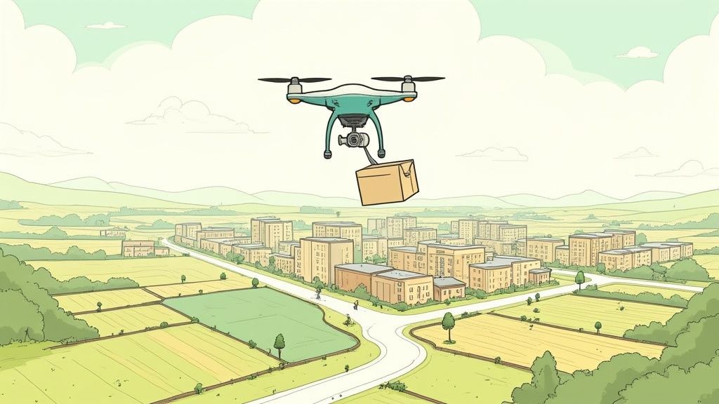
Medical Delivery to Remote Communities
For someone in a remote village, cut off by mountains or rough terrain, getting urgent medical supplies like blood, vaccines, or antivenom can be the difference between life and death. Traditional transport might take days to get there—if it can get there at all.
This is arguably one of the most powerful examples of what a BVLOS drone can do. Companies around the globe are now building "sky highways," using automated drones to deliver small, critical medical packages directly to rural clinics. A journey that once took hours by road now takes mere minutes by air. Each flight can be a lifeline, showcasing the incredible humanitarian potential of this technology.
Public Safety and Emergency Response
When disaster strikes, every second counts. In a search and rescue mission after an avalanche or in a sprawling forest, a BVLOS drone can cover huge areas much faster than teams on foot.
Kitted out with thermal cameras, these drones can pick up a person's heat signature from hundreds of feet in the air, guiding rescuers straight to a stranded individual. During major events like wildfires or floods, a BVLOS drone gives incident commanders a live, overhead view of the entire scene. This real-time awareness allows them to deploy resources effectively and keep their own teams out of danger. It's in these moments that BVLOS drones prove they aren't just an industrial tool, but a vital asset for saving lives.
Common Questions About BVLOS Drone Operations
As the world of unmanned aviation pushes past the old limits, it’s only natural for questions to pop up. For operators, business owners, and tech enthusiasts alike, the jump from flying within sight to operating a drone miles away is a big one, raising valid points about safety, technology, and just how accessible this is.
This section tackles those common questions head-on. We’ll give you clear, straightforward answers to help you get a solid grasp on the topic and clear up any confusion. From regulatory hurdles to what happens in an emergency, these insights will give you the practical knowledge you need.
What Is The Biggest Challenge To Widespread BVLOS Adoption?
The single greatest challenge is, without a doubt, safely integrating unmanned aircraft into the same airspace as traditional, manned aircraft. While the technology for BVLOS flight is largely ready to go, the real hurdle is proving its safety to aviation authorities like the FAA in the U.S. or EASA in Europe. This isn't a quick conversation; it's a complex, data-driven process.
Regulators need an extremely high level of confidence that a drone system can operate with a safety level equivalent to a piloted plane. Getting there means overcoming a few key obstacles:
Standardized Detect and Avoid (DAA) Performance: We need DAA systems that are universally accepted and proven to reliably spot and maneuver around all kinds of air traffic, from commercial jets to hot air balloons.
Reliable Command and Control (C2) Links: The connection between the pilot on the ground and the drone in the air has to be virtually unbreakable. This is a real challenge, especially in areas with spotty cell service or satellite coverage.
Public and Regulatory Trust: Ultimately, it's about building confidence among the public and policymakers that large-scale autonomous flights are fundamentally safe.
Clearing this regulatory mountain is the final key to unlocking the massive commercial potential of BVLOS operations across every industry you can imagine.
How Does A BVLOS Drone Avoid Collisions?
A BVLOS drone steers clear of collisions using a sophisticated stack of technology known as Detect and Avoid (DAA). It's best to think of this not as a single gadget, but as a whole sensory and response system that acts as the drone's digital eyes, ears, and reflexes. It pieces together a complete, 360-degree picture of the surrounding airspace.
To handle different types of air traffic, the system is multi-layered.
Cooperative Aircraft Detection: First, it uses an ADS-B (Automatic Dependent Surveillance-Broadcast) receiver. This device "listens" for the location signals that most modern manned aircraft are required to transmit, making them easy to spot and track from miles away.
Non-Cooperative Target Detection: But what about aircraft that don't broadcast a signal, like gliders, balloons, or older planes? For these "non-cooperative" targets, the drone relies on active sensors. These are typically small, lightweight onboard radar or LiDAR systems that actively scan the environment, much like a ship's radar.
Intelligent Decision-Making: All this data streams into an onboard computer. This processor uses advanced algorithms—often powered by AI—to fuse all the information, predict the flight paths of nearby objects, and flag potential collision risks long before they become a problem.
If a risk is detected, the system can automatically execute a pre-planned avoidance maneuver, like climbing, descending, or veering off course, all without a single command from the remote pilot.
Key Insight: A multi-layered DAA system is the backbone of BVLOS safety. It is the core technology that allows a drone, with no pilot's eyes on it, to safely deconflict with other aircraft and act like a responsible citizen of the sky.
Can I Fly A Regular Consumer Drone BVLOS?
No, you absolutely cannot legally or safely fly a standard consumer drone—like a DJI Mavic or an Autel EVO—in a BVLOS operation. This is a common and critical point of misunderstanding. These popular drones are specifically designed and certified only for Visual Line of Sight (VLOS) flying.
There are a few fundamental reasons why they just aren't cut out for BVLOS missions:
Lack of Redundancy: Consumer drones don't have the backup systems (like dual flight controllers or redundant power circuits) that are mandatory for ensuring reliability over long distances. A single point of failure out of sight could be catastrophic.
Inadequate C2 Links: The radio links on these drones are built for a range of a few miles in perfect conditions. They aren't designed for the robust, long-range satellite or cellular connections needed to maintain control far beyond what you can see.
No Certified DAA Systems: They completely lack the certified Detect and Avoid hardware and software that aviation authorities require to safely see and avoid other air traffic.
Trying to fly a consumer drone BVLOS is not only illegal in just about every country, but it's also incredibly dangerous. You’d have no reliable way to see and avoid other aircraft or handle a lost connection from miles away. To get a better handle on the rules of the sky, you can [master the drone laws with your essential compliance guide](https://www.jabdrone.com/post/master-the-drone-laws-your-essential-compliance-guide), which really clarifies these distinctions.
What Happens If A BVLOS Drone Loses Its Connection?
This is called a "lost link" or "lost C2" scenario, and it's one of the most critical emergencies every professional BVLOS system is designed to handle automatically. The moment the drone's flight controller detects it can no longer talk to the ground station, it immediately triggers a pre-programmed contingency plan.
This plan isn't decided on the fly. It's carefully mapped out by the pilot during mission planning to ensure the safest possible outcome based on the specific flight path and environment.
The drone will typically kick into one of several pre-determined actions:
Loiter in Place: The drone might be programmed to hover in a safe, pre-defined holding pattern for a certain amount of time, giving it a chance to re-establish the connection.
Return to Home (RTH): This is the most common procedure. The drone will autonomously fly itself back along a safe, pre-planned route to its takeoff point or another designated recovery location.
Land Immediately: If there's a safe, pre-vetted emergency landing zone nearby and continuing the flight is seen as the riskier option, the drone can be programmed to perform an autonomous landing on its own.
This automated fail-safe logic is a cornerstone of BVLOS safety. It ensures that even if the pilot loses control, the aircraft has a clear, safe, and predictable set of instructions to follow.
At JAB Drone, we're committed to providing you with the most accurate and practical information to help you stay ahead in the world of unmanned aviation. Whether you're a professional operator or a dedicated enthusiast, our expert guides and reviews are here to support your journey. Explore more at https://www.jabdrone.com.
Comments