Sensors for Drone Guide: What Every Pilot Needs to Know
- Paul Simmons

- Jun 23, 2025
- 13 min read
Why Sensors Matter More Than You Think
Imagine trying to drive a car blindfolded with your ears plugged. You wouldn't know your speed, your direction, or if a wall was right in front of you. That's what a drone without its sensors experiences—it's just a flying brick, not an intelligent machine. Modern drones are much more than just airborne cameras; they are advanced data-gathering platforms that rely on a network of sensors for drone operations to stay stable, aware, and useful.
These small technological components work together like a well-practiced orchestra, each playing a vital role in keeping your drone in the air and on task. They are the drone's senses, giving it the ability to perceive its surroundings, maintain balance, and carry out complex jobs with high precision.
The Nervous System of Your Drone
Think of the sensor suite as the drone's central nervous system. It constantly collects information about the drone's own state and its environment, sending this data to the flight controller—the drone's brain. This steady stream of information allows for thousands of tiny adjustments every single second.
For Stability: An Inertial Measurement Unit (IMU) is like the drone's inner ear, sensing its tilt, rotation, and acceleration to keep it level.
For Awareness: Environmental sensors like LiDAR or ultrasonic modules act as the drone's eyes and ears, detecting obstacles to avoid collisions.
For Purpose: Mission-specific sensors, such as a thermal or multispectral camera, gather the specialized data that defines the drone’s job.
Without this connected system, a drone would be uncontrollable. It couldn't hover steadily, navigate a planned route, or perform any meaningful task. Whether it's a simple hobby drone capturing a sunset or a commercial unit inspecting a wind turbine, it's the sensors that make the mission a success.
From Toys to Industrial Tools
The development of sensors for drone applications is the main reason UAVs have shifted from being simple remote-controlled toys to essential industrial tools. This technological progress has sparked a major market expansion. The global drone sensor market was valued at about $1.09 billion in 2024 and is expected to reach $1.34 billion in 2025, showing an impressive compound annual growth rate (CAGR) of 22.0%. This rapid growth shows how much industries now depend on drone-captured data for important operations. You can find more details on this trend in recent market analysis.
Understanding this sensory network is key. Whether you're a professional pilot or a weekend flyer, knowing how these parts work together will change how you see flying and what you can accomplish with your drone.
1. Flight Control Sensors: Your Drone's Inner Balance System
Have you ever watched a drone hang perfectly still in the air, even with a gusty wind trying to push it around? What you're seeing is the magic of its flight control sensors. Think of this core group of components as the drone's inner ear—the system that helps you maintain your balance without even thinking about it. This sensory suite is the bedrock of any controlled flight, constantly working behind the scenes to keep the drone stable and oriented.
This infographic breaks down a drone's core sensory components, including the vital flight control and positioning systems that enable it to navigate the world.
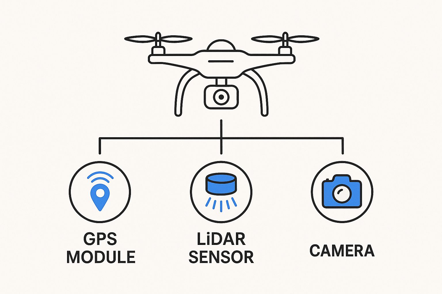
As the diagram shows, positioning, navigation, and imaging sensors create an interconnected system, allowing the drone to perceive and interact with its environment.
The Unseen Heroes: IMU and Barometer
At the heart of this system lies the Inertial Measurement Unit (IMU), a small but mighty package that houses two critical sensors:
Gyroscopes: These measure the drone’s rotational speed, telling it how fast it's tilting, rolling, or turning on any axis.
Accelerometers: These detect linear motion, informing the flight controller how quickly the drone is moving up, down, forward, or sideways.
The IMU provides a nonstop stream of data about the drone's movement and orientation. The flight controller analyzes this information thousands of times per second, making tiny adjustments to the speed of each motor to cancel out any unwanted motion. The IMU is so crucial that a drone literally cannot fly without one. These inertial sensors are fundamental for navigation and stability, which is why they currently hold the largest market share in the drone sensor industry.
While the IMU masters orientation, the barometric pressure sensor (or barometer) takes charge of altitude. By measuring changes in atmospheric pressure, it can determine the drone's height above sea level with impressive accuracy. This allows it to hold a steady altitude, a vital feature for capturing smooth video and executing automated flight paths.
To give you a clearer picture of how these essential components work together, the table below breaks down their functions, performance, and common applications.
Essential Flight Control Sensors Breakdown
Complete comparison of critical navigation sensors including performance specs, power requirements, and real-world applications
Sensor Type | Core Function | Precision Level | Power Draw | Price Range | Best Use Cases |
|---|---|---|---|---|---|
Gyroscope (in IMU) | Measures rotational velocity (tilt, roll, yaw) | High | Low | Low (Part of IMU) | Basic flight stabilization, acrobatic maneuvers |
Accelerometer (in IMU) | Measures linear acceleration (up/down, forward/back) | High | Low | Low (Part of IMU) | Position tracking, velocity control |
Barometer | Measures atmospheric pressure for altitude | Medium | Very Low | Low | Altitude hold, vertical positioning for photography |
GPS Module | Determines geographic location via satellites | High (outdoors) | Medium | Moderate | Position hold, return-to-home, waypoint navigation |
This table highlights how each sensor contributes a unique piece of information. The IMU provides the raw "feel" of movement, the barometer gives it a sense of "up," and the GPS provides a "map" of its location in the world.
Your Drone's Compass and Map: GPS
The final piece of this stability puzzle is the Global Positioning System (GPS) module. Acting as the drone's map and compass, it communicates with a network of satellites to pinpoint its exact location on Earth. This sensor for drone positioning unlocks some of the most valuable features pilots rely on:
Position Hold: Lets the drone lock onto its coordinates and hover in one spot, resisting wind drift.
Return-to-Home: A critical safety feature that automatically brings the drone back to its takeoff point if the control signal is lost.
Automated Waypoint Missions: Enables the drone to fly a pre-programmed route without any real-time manual input, perfect for mapping and surveying.
Without a GPS signal, a drone would be at the mercy of the wind, unable to hold its position or follow an automated flight plan. By combining the data from the IMU, barometer, and GPS, the flight controller gets a complete, real-time understanding of its state. This fusion of information is what makes the stable, reliable, and intelligent flight we see in modern drones possible.
Environmental Awareness: Giving Your Drone Superpowers
Beyond simply keeping itself level, the most effective sensors for drone operations are those that give it a sense of the world around it. These environmental sensors change a drone from a basic flying machine into an intelligent explorer, giving it the power to see and interpret its surroundings with incredible detail. They are the key to unlocking autonomous flight, detailed mapping, and essential safety features.
Seeing with Sound and Light
Think of an ultrasonic sensor as a drone's personal sonar system. It sends out high-frequency sound waves and measures the time it takes for those waves to bounce off something and return. This simple but effective method creates an invisible safety bubble around the drone. It’s a core technology for basic obstacle avoidance, particularly at low speeds and close to the ground.
For more detailed and complex environmental mapping, LiDAR (Light Detection and Ranging) sensors are the gold standard. Instead of sound, LiDAR shoots out thousands of laser pulses every second. These pulses reflect off surfaces, and the sensor measures the time-of-flight for each one to create a dense, three-dimensional "point cloud" of the terrain. LiDAR is so accurate it can see through forest canopies to map the ground underneath or spot tiny changes on construction sites over time. You can get a deeper look into how these systems operate in our guide on drone collision avoidance systems.
This LiDAR image of a forested area shows how laser pulses create a detailed 3D model of the terrain.
The image clearly shows how LiDAR can map both the top of the tree canopy and the ground beneath it—a task impossible for regular cameras.
Navigating Without GPS
What happens when a drone flies indoors or through a dense city where GPS signals can't reach? This is where optical flow sensors become essential. Typically mounted on the drone’s underside, these sensors are made up of a small camera and a processor. They constantly take pictures of the ground below and analyze how textures and patterns move from one frame to the next.
By tracking this visual movement, the drone can figure out its own motion and hold its position with rock-solid stability, even without a satellite signal. This sensor for drone stability is what makes safe indoor flights possible for tasks like warehouse inspections or getting cinematic shots in tight spaces. These environmental sensors don't just gather data; they give your drone the awareness it needs to make smart, independent decisions, turning it from a simple tool into a true partner.
Imaging Beyond the Visible: Advanced Camera Systems
While many drones are known for carrying standard cameras, the world of modern sensors for drone applications goes far beyond what our eyes can see, opening up realms that provide almost magical insights. These advanced camera systems aren't just for snapping pretty pictures; they are powerful analytical tools that capture data across different light spectrums, turning invisible information into valuable intelligence.
Seeing Heat: Thermal Imaging Sensors
Imagine a pair of glasses that sees heat instead of light. That's essentially what a thermal imaging sensor does. These sensors build pictures based on the heat signatures that objects give off, making them indispensable in situations where normal vision is useless. Firefighters, for instance, use thermal drones to find people trapped in smoky buildings, and wildlife biologists can track nocturnal animals without disrupting their habitats. They function day or night, translating temperature differences into a clear visual map.
Capturing the Unseen: Multispectral and Hyperspectral Cameras
If thermal sensors see heat, then multispectral cameras see colors that are completely invisible to humans. They capture light in specific, narrow bands across the electromagnetic spectrum. It’s like having a camera that can separately photograph red, green, blue, and several shades of infrared all at once. By analyzing these different bands, experts can assess plant health, identify soil composition, and even detect water stress in crops long before it’s visible to the naked eye. Hyperspectral sensors take this a step further, capturing hundreds of narrow bands for even more detailed analysis.
These advanced sensor capabilities enable drones to perform more complex aerial data acquisition tasks, improving both accuracy and operational efficiency. Industries like agriculture have seen immense benefits from precision farming techniques using drone sensors, while security sectors rely on their improved detection capabilities. You can learn more about how these capabilities are transforming industries and driving the drone sensor market forward.
Keeping It Smooth and Smart
Of course, capturing advanced imagery is pointless if the picture is shaky. This is where sophisticated stabilization systems, or gimbals, come into play. They use their own set of IMUs to predict and instantly cancel out the drone's movements, delivering perfectly smooth footage even in windy conditions. Increasingly, AI-powered image processing is happening directly on the drone itself. This on-the-fly intelligence allows the drone to autonomously identify crop disease, count livestock, or spot structural defects on a bridge, all within a single flight. Choosing the right imaging sensor for your drone turns it from a simple flying camera into a powerful data collection platform.
Specialized Mission Sensors: Beyond Standard Equipment
While flight and imaging sensors are the workhorses of most drone operations, a whole other world of specialized sensors exists for missions that are highly specific and demanding. These tools can turn a standard drone into a purpose-built problem-solver for industries from public safety to environmental science. They are designed to detect things completely invisible to our own senses, gathering critical data that would otherwise be dangerous or impossible to collect.
Pushing the Boundaries of Data Collection
Specialized sensors can perform tasks that once felt like science fiction. Picture a drone equipped with gas detection sensors patrolling an industrial plant. It can pinpoint hazardous chemical leaks in real time, alerting teams long before human workers are put in harm's way. In the same way, radiation sensors allow for the safe inspection of nuclear power facilities, gathering essential maintenance data without exposing personnel to unsafe environments.
These advanced capabilities extend into other complex fields as well:
Acoustic Sensors: These sensors can "listen" for trouble. When mounted on a drone, they can identify subtle vibration patterns in a wind turbine’s machinery from hundreds of feet away, flagging potential equipment failure.
Magnetic Sensors: Used in geology and archaeology, these sensors can map underground mineral deposits or help find the foundations of buried historical buildings.
Synthetic Aperture Radar (SAR): This powerful sensor technology sees right through clouds, fog, and darkness to create detailed ground images, making it perfect for disaster response and surveillance missions regardless of weather.
The Future of Specialized Sensing
The innovation doesn't stop there. New bio-sensors are now being used to monitor the health of entire ecosystems. These sensors can help scientists track water pollution levels in remote lakes or analyze air quality to see how it affects local wildlife. Each unique sensor opens up new possibilities, solving complex real-world problems and adding new value to drone operations. If you want to see what advanced payloads are becoming popular, you might find our guide on the top sensors for drones in 2025 interesting.
Ultimately, these specialized tools are more than just technical add-ons. They are what enable drones to perform some of the most critical and high-impact jobs across countless industries.
2. Smart Sensor Selection: Matching Tools to Missions
Choosing the right sensors for a drone isn’t about picking the most expensive gadget off the shelf; it's about making intelligent trade-offs. Think of it like packing for a long hike. You wouldn’t carry a heavy arctic parka for a summer day trip. In the same way, you need to match your drone's payload to the specific demands of the mission, carefully balancing performance against real-world limits like weight, power draw, and budget.
A smart selection process always begins with a clear mission objective. What information do you absolutely need to collect, and what level of precision is non-negotiable? Answering this question first helps you avoid common and often expensive mistakes.
The Trade-Off Triangle: Performance, Weight, and Cost
Every sensor decision forces you to navigate a triangle of competing factors. A high-resolution LiDAR sensor might offer incredible detail, but its weight could slash your flight time in half. A cheaper camera might save you money upfront, but if its image quality is too low, the data you collect could be useless for photogrammetry.
This is where experienced professionals stand out. They don't just stare at spec sheets; they consider the entire operational picture. A common mistake is equipping a drone with an ultra-high-resolution camera for a large-scale mapping mission where battery life is far more critical than pixel count. A lighter sensor would have enabled longer flights, allowing the operator to cover more ground efficiently. Another frequent error is relying on GPS-dependent sensors for indoor missions or in "urban canyons" between tall buildings, where signals are unreliable and the expensive equipment becomes ineffective.
Case Studies in Sensor Selection
To see this decision-making process in action, let’s look at two real-world scenarios:
Agricultural Survey: A farmer needs to monitor crop health across a sprawling 500-acre farm. Instead of a heavy, power-draining LiDAR unit, they select a lightweight multispectral sensor. This sensor is designed to capture the exact light bands that indicate plant stress. The lighter payload translates to longer flight times, making it possible to survey the entire farm on a single battery, saving both time and operational costs.
Bridge Inspection: An engineering firm is tasked with finding tiny stress fractures on a concrete bridge. They choose a drone with a high-resolution RGB camera mounted on a flexible gimbal. Here, the priority isn't range but capturing extreme close-up detail from multiple angles. They pair this primary sensor with an optical flow sensor to maintain stable flight near the structure, where GPS signals can be weak or bounce unpredictably.
In both examples, the specific goal of the mission drove the sensor choice, leading to an efficient and successful outcome. This strategic approach ensures every gram of payload has a clear purpose, delivering exactly the data you need.
To help you plan your own missions, the following table breaks down sensor combinations for common applications, along with practical considerations for each.
Mission Type | Essential Sensors | Optional Upgrades | Critical Factors | Investment Level |
|---|---|---|---|---|
Precision Agriculture | Multispectral, High-Res RGB | Thermal | Flight Time, Data Processing Workflow, Spectral Bands | Moderate |
Construction Site Monitoring | High-Res RGB, GNSS/RTK | LiDAR, Oblique Cameras | Positional Accuracy (cm-level), Data Consistency | Moderate to High |
Infrastructure Inspection | High-Res RGB with Zoom | Thermal, LiDAR | Close-up Detail, Gimbal Flexibility, Obstacle Avoidance | Moderate to High |
Search & Rescue (SAR) | Thermal, HD RGB with Zoom | Loudspeaker, Spotlight Payload | Low-Light Performance, Flight Endurance, Weather Resistance | High |
Cinematography & Media | Cinema-Grade RGB Camera | FPV System | Image Quality (Dynamic Range, Color Science), Stability | High to Very High |
Environmental Monitoring | Multispectral, Hyperspectral | Air Quality Sensors | Sensor Sensitivity, Repeatability of Flights | Moderate to Very High |
This guide shows that the "best" sensor is rarely a single piece of equipment. More often, it's a carefully selected combination that works together to achieve a specific goal within the constraints of your budget and flight platform.
What's Coming Next: The Future of Drone Sensing
The world of drone sensors is accelerating, introducing abilities that once seemed like pure science fiction. The next generation of innovation isn't just about making sensors smaller or more precise; it's about making them truly intelligent. This evolution is set to completely change how drones perceive and interact with their surroundings.
Onboard Intelligence and Swarm Communication
One of the most exciting developments is embedding artificial intelligence directly into the sensors for a drone. Think of a thermal camera that doesn't just show heat signatures but can instantly identify a missing hiker and alert rescue teams on its own. This onboard-AI cuts down on the constant back-and-forth with a ground station, allowing drones to make faster, more autonomous choices in urgent situations.
Beyond individual smarts, drones are now learning to collaborate through swarm intelligence. Instead of a single drone working alone, a group can pool their sensor data in real time. This creates a collective awareness far more powerful than what any single unit could manage. For instance, one drone’s LiDAR might map an obstacle while another’s optical sensor confirms what it is, building a complete, shared understanding of the environment. This type of collaborative sensing is a cornerstone of many new drone technology innovations.
New Frontiers in Sensing Technology
New sensor types are also on the horizon, promising to give drones extraordinary new powers.
Quantum Sensors: These offer a new level of sensitivity, capable of measuring tiny fluctuations in gravity and magnetic fields. This could unlock GPS-free navigation and enable incredibly detailed geological surveys to uncover underground resources or hidden archaeological sites.
Bio-Inspired Sensors: Researchers are drawing inspiration from nature, creating sensors that mimic the amazing navigation systems of birds and insects. These designs are leading to major advances in obstacle avoidance and flight efficiency, helping drones move through crowded spaces with a natural, fluid grace.
As miniaturization continues to pack more capability into smaller and smaller packages, these advanced sensors for drone platforms are becoming more widely available. This ongoing progress means the drones of tomorrow will be more perceptive, independent, and capable than we've ever seen.
Ready to explore the skies with the latest technology? The team at [JAB Drone](https://www.jabdrone.com) is your ultimate resource for expert reviews, in-depth guides, and all the information you need to stay ahead.
Comments