Drone Real Estate Photography: Boost Listings
- A.E. Williams

- Apr 27, 2025
- 15 min read
The Game-Changing Impact of Drone Real Estate Photography
Drone real estate photography has dramatically altered property marketing, evolving from a high-end extra to an essential sales tool. Aerial images forge emotional connections with potential buyers that traditional photos simply can't match. This leads to quicker sales, happier clients, and a significant competitive advantage for real estate agents.
How Drone Photography Benefits Real Estate Listings
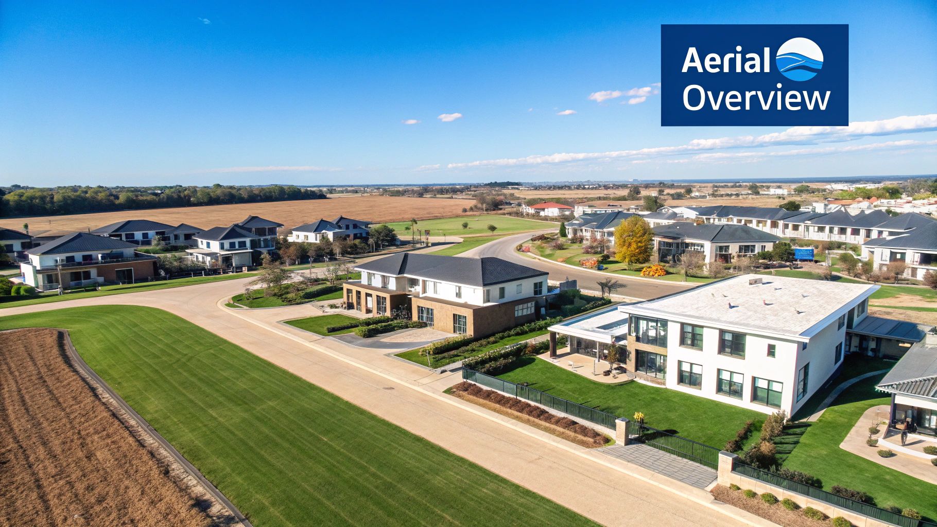
Drone photography provides a unique perspective, showcasing a property and its surroundings in a way ground-level photography can't. This aerial view offers a comprehensive overview, highlighting key factors that influence purchasing decisions.
Lot Size and Boundaries: Clearly defined property lines give buyers a realistic sense of scale and space. This is particularly valuable for larger properties or those with unusual shapes.
Neighborhood Context: Showcase the surrounding neighborhood, emphasizing proximity to schools, parks, shopping centers, and other amenities. This adds valuable context, helping buyers envision themselves in the area.
Landscaping and Outdoor Features: Capture breathtaking views of gardens, pools, patios, and other outdoor amenities. This effectively showcases the property's full potential and curb appeal.
Proximity to Key Locations: Clearly display the property's location relative to landmarks, transportation hubs, and other points of interest. This practical information can be a decisive factor for many buyers.
Faster Sales and Increased Buyer Engagement
The positive effect of drone photography on sales is clear. Properties featuring aerial images generate considerably more interest and sell more quickly than those without. For instance, Multiple Listing Service (MLS) data shows properties with drone photography sell much faster. This heightened engagement translates to a more streamlined sales process and greater satisfaction for both buyers and sellers.
The increasing use of drone technology by real estate professionals further supports this. This reliance on drones is unsurprising, given the market's rapid expansion. The global drone photography services market is projected to reach $1.89 billion by 2029, growing at a 19.5% Compound Annual Growth Rate (CAGR), fueled by rising demand in sectors like real estate. As of 2024, 61% of U.S. real estate agents already use drones for their listings. Explore this topic further
Enhancing Property Value and Buyer Confidence
Beyond showcasing physical attributes, drone photography elevates the perceived value of a property. The captivating aerial perspectives create a sense of prestige and exclusivity, boosting overall appeal. The comprehensive view provided by drone imagery also instills buyer confidence. By seeing the entire property and surrounding area, potential buyers can make informed decisions, minimizing hesitation and facilitating faster closings.
The Future of Real Estate Marketing
Drone photography is not simply a passing fad; it's a powerful tool reshaping the real estate industry. As drone technology continues to evolve, we can anticipate even more creative applications in property marketing. From 3D modeling and virtual tours to interactive maps and augmented reality experiences, drones are set to play a larger role in connecting buyers and sellers. This movement towards aerial visualization is transforming how properties are marketed and sold worldwide.
Why Buyers Can't Resist Properties With Aerial Imagery
Drone real estate photography isn't just a passing fad; it's a powerful marketing tool that deeply resonates with potential buyers. It offers compelling advantages that significantly influence purchasing decisions, going far beyond simple novelty. Let's explore how aerial perspectives showcase property elements that traditional ground-level photography simply can't capture.
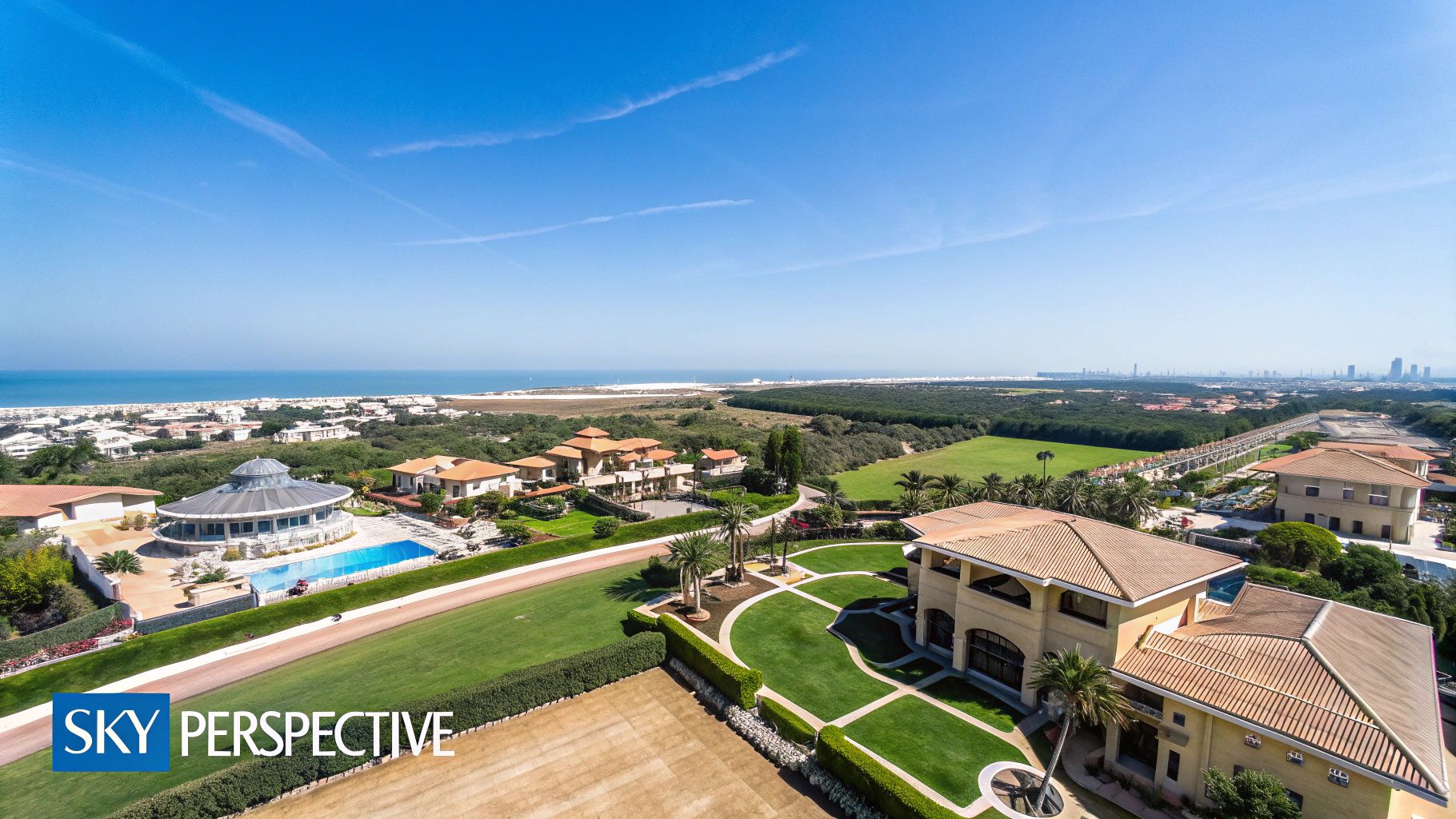
Unveiling the Unseen: A Comprehensive View
Imagine trying to understand the full scope of a property from the ground. Obstacles such as trees, fences, and neighboring buildings often obstruct the view, making it difficult to grasp the property's layout and its relationship to the surrounding area. Drone photography eliminates these limitations, providing a sweeping overview that reveals the property's true potential. Buyers gain a clear understanding of the layout, boundaries, and how the property sits within its surroundings.
Consider a property with a large backyard adjacent to a scenic park. Ground-level photos might show parts of the yard, but drone photography showcases the entire expanse. This highlights its connection to the park and provides a sense of scale that traditional photos can't match. Furthermore, aerial views capture landscaping features, like gardens, pools, and patios, with stunning clarity, emphasizing their design and integration within the property.
Context is Key: Placing the Property in Perspective
Drone imagery provides crucial context by showcasing the property within its neighborhood. This allows buyers to visualize the proximity to key amenities like schools, shops, and transportation hubs. This added information empowers buyers to make informed decisions, leading to increased confidence in their purchase. This is especially valuable for buyers relocating to a new area, giving them a virtual tour of the neighborhood and helping them envision their potential new life.
The Psychology of Persuasion: Building Buyer Confidence
The ability to visualize the entire property and its surroundings creates a significant psychological impact. Buyers feel more secure and less hesitant when they have a comprehensive understanding of their potential purchase. It reduces uncertainty and helps them imagine themselves living in the property. This increased confidence often translates to faster sales and a smoother closing process. Properties featuring drone photography sell considerably faster. MLS data indicates a 68% faster sales rate compared to listings using standard images. This is reinforced by the increasing specialization in aerial expertise. Currently, 43% of drone-using realtors hire professional drone operators, and another 22% seek formal training in drone operation. This points to a growing recognition of the value of professional drone photography. The real estate drone services market is predicted to grow from $0.49 billion in 2024 to $1.13 billion by 2029, representing an 18.1% CAGR. This growth is driven by the increasing demand for immersive buyer experiences, enabled by technologies like 3D modeling, thermal imaging, and digital twins. More statistics on this growth are available here.
Highlighting Key Features: Strategic Drone Shots
Strategic drone shots can significantly elevate a property's appeal. A "reveal" shot, starting with a wide angle and gradually zooming in on the property, builds anticipation and creates a dramatic effect. An orbit shot, circling the property at a constant altitude, offers a 360-degree view, highlighting architectural details. By strategically showcasing key selling points, drone photography transforms ordinary listings into compelling opportunities, giving agents a competitive edge. These captivating visuals not only attract more potential buyers but also contribute to a higher perceived property value.
To illustrate the differences, let's look at a comparison:
Drone vs. Traditional Real Estate Photography Comparison This table compares key aspects of drone photography and traditional ground-level photography for real estate marketing.
Feature | Drone Photography | Traditional Photography | Impact on Sales |
|---|---|---|---|
Perspective | Aerial, comprehensive view | Ground-level, limited view | Drone photography provides a more complete understanding of the property and its surroundings, leading to increased buyer interest. |
Context | Shows property within the neighborhood | Focuses on individual property features | The broader perspective offered by drone photography helps buyers visualize the property's location and proximity to amenities, influencing their purchase decision. |
Visual Appeal | Dynamic, engaging visuals | Static, traditional images | The captivating nature of drone photography attracts more attention and generates greater interest in the property, potentially leading to faster sales. |
Cost | Can be higher than traditional photography | Generally less expensive | While drone photography might have a higher initial investment, the potential for faster sales and increased property value can outweigh the cost difference. |
In conclusion, the table highlights the distinct advantages of drone photography in providing a comprehensive perspective, valuable context, and enhanced visual appeal, all of which contribute positively to sales outcomes.
This combination of comprehensive views, contextual information, and strategic presentation makes drone photography an essential tool for showcasing properties and capturing the attention of potential buyers.
Finding Your Perfect Drone Setup: Equipment That Delivers
This guide helps you choose the right drone equipment for real estate photography. We'll cut through the technical jargon and offer practical advice based on property size and your business needs. Whether you're shooting smaller homes or sprawling luxury estates, we'll cover the drones, accessories, and software you need for a smooth workflow.
Choosing the Right Drone for the Job
The ideal drone depends on your individual requirements and budget. Photographing a small house requires a different approach than capturing a large estate. Let's break down some options:
Entry-Level: The DJI Mini 3 Pro is a fantastic starting point. Its portability and lightweight design make it easy to transport. It also produces high-quality images, especially with techniques like bracketing, making it perfect for agents new to drone photography.
Mid-Range: The DJI Air 3S offers a substantial improvement in image quality thanks to its 1-inch sensor and multiple lens options. It’s a versatile choice, balancing portability with advanced features like improved obstacle avoidance and longer flight times. This makes it suitable for a wide range of property sizes.
Professional: For professional-grade results, the DJI Mavic 3 Pro stands out. Its advanced camera system, featuring a larger sensor and a telephoto lens, captures exceptional images ideal for high-end real estate. Keep in mind that this option requires a larger investment and more advanced piloting skills.
Essential Accessories for Elevated Imagery
While the drone is the centerpiece of your setup, accessories can significantly improve your imagery and streamline your workflow. Here are a few must-haves:
Extra Batteries: Multiple batteries are essential for longer shoots, ensuring you can capture everything you need without interruptions. This is particularly important for larger properties or when photographing multiple listings in a day.
ND Filters (Neutral Density): These filters control light entering the camera, allowing for slower shutter speeds in bright conditions, leading to a more cinematic look in videos and reducing motion blur in photos. ND filters are a key tool for achieving professional results.
Carrying Case: A dedicated carrying case protects your equipment during transport and helps keep everything organized. This is invaluable for professionals constantly on the move.
Streamlining Your Workflow: Software Solutions
Post-processing is vital in drone real estate photography. The right software can streamline your editing, virtual tour creation, and project management.
Photo Editing Software: Industry-standard programs like Adobe Lightroom and Adobe Photoshop provide powerful tools for enhancing your images and fixing imperfections, ensuring your photos present properties in the best possible light.
Drone Mapping Software: Specialized software like Pix4D allows you to create immersive 3D models and property maps, giving potential buyers a more interactive and engaging experience.
Camera Specifications: Focusing on What Matters
Understanding key camera specifications is crucial for capturing professional-quality images. Pay attention to these factors:
Sensor Size: A larger sensor generally performs better in low light and delivers images with a wider dynamic range, providing more detail and flexibility during editing.
Resolution: Higher resolution allows for larger prints and more cropping options without losing image quality, essential for high-impact marketing materials and online listings.
Lens Quality: High-quality lenses produce sharp, distortion-free images, accurately representing property features and capturing their true beauty.
Choosing the right drone, accessories, software, and understanding camera specifications are essential for producing stunning real estate photography. Consider your budget, the types of properties you shoot, and your desired level of control when making these decisions. This will ensure you have the perfect setup to elevate your listings and attract more buyers.
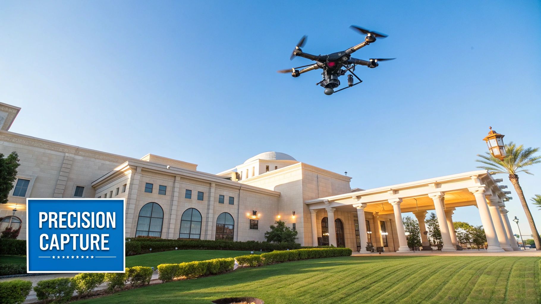
Mastering Drone Techniques That Showcase Properties Perfectly
Owning a top-notch drone is only the first step in real estate photography. This section explores the crucial techniques that elevate ordinary property photos into stunning marketing materials. We'll cover how to use your drone to tell a property's story, highlighting its best features and attracting potential buyers.
Optimal Flight Altitudes and Timing
Altitude drastically impacts how a property is perceived. Too low, and you get distorted perspectives. Too high, and the property becomes lost in the surroundings. An altitude between 100 and 400 feet usually provides the best balance. This allows you to feature both the property and its surroundings.
This can change depending on the property. A large estate might look better from a higher altitude, showcasing its size. A smaller home might benefit from a lower perspective to emphasize details.
Timing also matters. The golden hour – shortly after sunrise or before sunset – offers soft, warm lighting. This enhances a property's appearance. Midday sun can be harsh and create unwanted shadows. Understanding natural light is key for great photos.
Composition Principles For Engaging Imagery
Basic composition principles can improve your drone photography. The rule of thirds is a great example. Imagine your image divided into nine equal parts by two horizontal and two vertical lines.
Placing key elements along these lines or at their intersections creates a balanced, engaging composition. Leading lines also add depth. Driveways, paths, or even a pool's edge can guide the viewer's eye toward the main subject.
Advanced Drone Maneuvers
Beyond basic shots, advanced maneuvers make your real estate photography dynamic. A revealing shot starts wide and gradually zooms in on the property. This builds anticipation and shows the property’s location.
An orbit shot, circling the property at a consistent altitude, provides a full 360-degree view. This immersive view lets potential buyers see the property from every angle. Learn more: How to master more drone maneuvers.
Camera Settings and Post-Processing Techniques
Even with perfect technique and composition, incorrect camera settings can hurt image quality. Knowing how aperture, shutter speed, and ISO interact is crucial for well-exposed, sharp photographs.
Bracketing, taking multiple shots at different exposures, can help in challenging light. These can be combined in post-processing for better dynamic range. Post-processing can enhance images, but subtlety is key. Adjust brightness, contrast, and sharpness for better quality, but avoid overdoing it. The goal is a natural, realistic look.
Showcasing Unique Selling Points
Drones offer an amazing way to showcase a property's unique features. A great view, a pool, or nearby amenities can all be highlighted. For large properties, a drone site map can show the entire layout.
To help you plan your next shoot, let's take a look at the following table:
Drone Photography Shot Types for Different Property Features This table outlines the most effective drone shot types for showcasing various property features and amenities
Property Feature | Recommended Shot Type | Altitude Range | Key Composition Tips |
|---|---|---|---|
Swimming Pool | Top-down, angled | 100-200 ft | Use the pool as a leading line towards the house. Capture during the golden hour for optimal lighting. |
Landscaping | Wide-angle, orbit | 200-300 ft | Capture the entire expanse of the landscaping. Use the rule of thirds to create a balanced composition. |
Roofline | Angled, close-up | 50-100 ft | Highlight architectural details. Avoid direct overhead shots to prevent distortion. |
Entire Property | Wide-angle, reveal | 300-400 ft | Showcase the property within its surroundings. Include nearby amenities like parks or bodies of water. |
This table provides a quick guide to capturing the best possible images of key property features. Remember to consider the specific property and its surroundings when planning your shots.
By mastering these techniques, you can take your real estate drone photography to the next level. Create compelling visuals that grab attention and drive sales.
Navigating FAA Rules Without Losing Your Mind
Don't let the complexities of FAA regulations deter you from exploring the exciting world of drone real estate photography. This section breaks down the essential requirements for legal commercial drone operation, making them easy to understand and implement. We'll cover everything from Part 107 certification and airspace restrictions to operational limitations and insurance considerations. We'll also discuss privacy concerns and how to verify the credentials of an outsourced drone operator.
Understanding Part 107 Certification
The Part 107 certification is a must-have for anyone using a drone for commercial purposes, which includes real estate photography. Issued by the FAA, this certification demonstrates your knowledge of drone regulations and safe operating procedures. The exam covers various topics, including airspace regulations, weather conditions, and emergency procedures. Obtaining this certification showcases your professionalism and commitment to operating legally.
Decoding Airspace Restrictions
Airspace regulations vary significantly depending on location. Certain areas, especially near airports or sensitive locations, have restrictions. Before every flight, it's crucial to check the airspace using apps like B4UFLY B4UFLY or Kittyhawk Kittyhawk. These apps provide real-time information on airspace restrictions, enabling you to plan your flights safely and legally. Ignoring airspace restrictions can lead to penalties.
Operational Limitations: Staying Safe and Legal
Commercial drone operations are subject to several operational limitations. These include a maximum altitude of 400 feet, visibility requirements, and restrictions on flying over people. Understanding and following these rules is vital for safe and legal operation. Always maintain visual line of sight with your drone and never fly in hazardous weather conditions. These simple precautions will help prevent accidents and ensure FAA compliance.
Insurance and Liability Considerations
Adequate insurance is crucial for drone real estate photography. Liability insurance protects you financially in case of accidents or property damage. Numerous insurance policies specifically cover drone operations. Discussing liability concerns with your client and ensuring they understand the associated risks is also recommended. Open communication can prevent misunderstandings and protect both parties.
Addressing Privacy Concerns
Respecting privacy is paramount in drone real estate photography. Avoid flying over neighboring properties without permission and be mindful of capturing images of individuals without their consent. Inform your client about privacy considerations and obtain their consent before starting the shoot. This transparent approach fosters trust and ensures a smooth, ethical process.
Verifying Operator Credentials (For Outsourcing)
If you decide to outsource drone services, verifying the operator's Part 107 certification and insurance coverage is essential. Request their portfolio and check references. This due diligence ensures you're collaborating with a qualified, reputable professional who understands the legal and ethical aspects of drone real estate photography. A thorough vetting process protects your business and guarantees high-quality, compliant aerial imagery. You can find more information on our site: Our sitemap for more information on drone photography.
DIY vs. Hiring Pros: Making The Smart Choice For Your Business
Deciding between handling drone real estate photography yourself or hiring a professional is a crucial business decision. This section helps you navigate this choice, considering your needs and circumstances. We’ll analyze costs, time commitment, and potential return on investment for both DIY and professional drone services.
Evaluating The Total Cost Of Drone Ownership
Building in-house drone capabilities involves significant upfront and ongoing expenses. The initial investment includes the drone itself, ranging from a few hundred dollars for entry-level models like the DJI Mini 3 Pro to several thousand for professional-grade equipment like the DJI Mavic 3 Pro. Essential accessories like extra batteries, ND filters, and a carrying case also add to the initial cost.
Beyond the initial purchase, ongoing costs include maintenance, repairs, software subscriptions for photo editing and drone mapping, and potentially training courses for piloting and photography techniques. Regular maintenance is essential for the drone’s longevity and optimal performance, while unexpected repairs can add unplanned expenses. Software subscriptions for professional photo editing software like Adobe Lightroom and Photoshop, as well as specialized drone mapping software like Pix4D, contribute recurring costs.
Comparing With Professional Drone Operator Pricing
Professional drone operators typically offer various pricing models. These can include flat rates per property, hourly rates, or package deals combining photography with other services. Understanding these structures helps you compare hiring a professional with owning your equipment. When deciding, understanding typical costs is helpful; review these pricing options. Look beyond the price and evaluate the operator’s portfolio, experience, and insurance coverage.
The Hidden Costs Of Time And Opportunity
Managing drone operations in-house requires a significant time investment. Learning to pilot a drone proficiently takes time and practice. Mastering drone photography techniques to showcase properties effectively requires additional dedication.
Post-processing images and videos, navigating FAA regulations, and securing necessary permits also consume valuable time. Consider the opportunity cost: dedicating your time to drone operations versus focusing on client interactions, property showings, and other revenue-generating tasks.
Case Studies: Different Business Models, Different Approaches
For real estate agents with a high volume of listings, investing in drone equipment and training might be justifiable. Capturing drone photography and videography on demand offers flexibility and control over marketing. However, for agents with fewer listings, partnering with a professional drone operator is often more cost-effective. Outsourcing allows agents to leverage specialized expertise without the ongoing expense and time commitment.
Hybrid Approach: Balancing Control And Expertise
A hybrid approach can offer the best of both worlds. Real estate agents might handle basic drone photography for smaller properties while outsourcing more complex shoots, like aerial videography or 3D mapping, to professionals. This allows greater control over routine photography while leveraging professional expertise for high-impact marketing materials.
Ultimately, the decision to go DIY or hire a professional depends on your business model, property volume, market positioning, and growth goals. Carefully weigh the total cost of ownership, the value of your time, and the potential return on investment to make an informed choice aligned with your business strategy.
Turning Great Drone Imagery Into Marketing That Converts
Stunning drone photography is only half the battle when it comes to effective real estate marketing. This section explores how to transform exceptional aerial imagery into a powerful marketing engine that drives tangible results. We'll delve into practical strategies for integrating drone content across various platforms, creating engaging property presentations that convert prospects into buyers.
Maximizing Impact: From Featured Photos to Video Tours
Drone imagery offers diverse applications in real estate marketing, and selecting the right image for the right purpose is crucial. High-quality aerial shots showcasing the entire property and its surroundings make ideal featured photos on listing websites like Zillow. They immediately capture attention and offer a comprehensive property overview.
Consider creating compelling video tours as well. Combine sweeping aerial footage with smooth ground-level shots to deliver a truly immersive property experience. Highlighting key features and amenities, both indoors and outdoors, engages potential buyers on an emotional level.
Crafting Promotional Materials: Leveraging Aerial Perspectives
Drone photography provides a unique perspective for creating eye-catching brochures, flyers, and social media content. Showcase the property from angles unattainable with traditional photography. This approach fosters a sense of exclusivity and intrigue, effectively capturing the attention of potential buyers. A dramatic aerial shot of a luxury home perched on a hillside, for example, can be far more impactful than a standard ground-level image.
When deciding between a DIY approach or hiring a professional, understanding typical costs is helpful. You can review these pricing options for more information.
Integrating Drone Content Across Platforms: A Cohesive Approach
Seamlessly integrating drone content across your marketing platforms creates a unified and professional brand image. Use consistent visuals and messaging on your website, social media channels like Instagram, email campaigns, and virtual tours to reinforce your brand identity and enhance property presentation.
Listing Websites: Feature high-resolution aerial images and videos prominently on listing platforms to attract more views and inquiries.
Social Media: Share captivating drone shots and short video clips on social media to engage your audience and generate buzz around your listings.
Email Campaigns: Include stunning aerial perspectives in your email marketing to entice potential buyers and drive traffic to your website.
Virtual Tours: Integrate drone footage into virtual tours to craft an immersive experience, allowing prospects to explore the property from every angle.
You might be interested in: How to master more about drone photography
Building Your Brand: Positioning Drone Imagery Strategically
Forward-thinking agents don't just use drone imagery as a standalone tactic; they weave it into their core marketing strategy. By consistently showcasing high-quality aerial perspectives, they establish themselves as innovative and tech-savvy professionals. This approach cultivates a distinct brand advantage, particularly in competitive markets.
Examples of Successful Campaigns
Several real estate professionals have leveraged drone photography to achieve remarkable results. One agent significantly increased her listing inquiries by featuring stunning aerial shots on social media, resulting in a 20% increase in sales within a year. Another agent used drone video tours to showcase luxury properties, leading to a 15% reduction in time-on-market compared to listings without video.
From Interest to Action: Moving Prospects Down the Sales Funnel
Strategic use of drone imagery can effectively move prospects through the sales funnel. Compelling aerial visuals initially capture their attention, while detailed video tours provide the necessary information for informed decisions. By showcasing the property’s unique features and surrounding environment, drone photography builds buyer confidence and encourages them to take action. The result is a more efficient sales process and a higher conversion rate.
Ready to elevate your real estate marketing with the power of drone photography? Visit JAB Drone to explore the latest drone technology, expert insights, and comprehensive resources to capture stunning aerial imagery and transform your listings into must-see opportunities.
Comments