A Guide to Drone LiDAR Mapping
- Paul Simmons

- Jul 14, 2025
- 14 min read
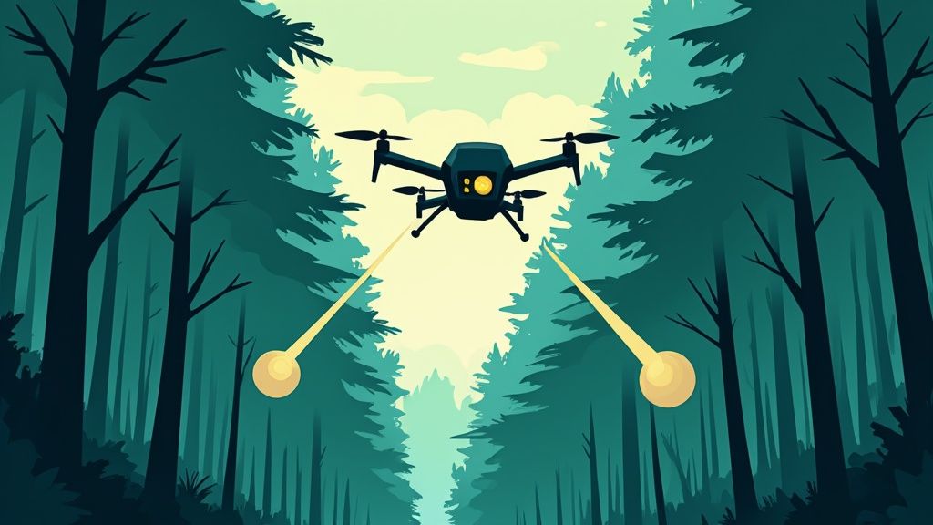
Ever tried to map a dense forest from the air? If you're using a standard camera, all you'll see is a sea of green. You can't see the actual ground. But with drone LiDAR mapping, that’s no longer a problem.
Think of it like a bat using echolocation to navigate in the dark. Instead of sound waves, a LiDAR sensor sends out millions of tiny laser pulses. These pulses bounce off the earth's surface and return to the sensor, measuring distances with incredible precision. The result is a highly accurate 3D model of the terrain, captured in stunning detail.
Why Drone LiDAR Mapping Is a Game Changer
The real magic of drone LiDAR mapping happens when you realize it's a faster, safer, and far more detailed way to survey than the old-school methods. By mounting a LiDAR (Light Detection and Ranging) sensor onto a drone, professionals can get around the kinds of obstacles that used to make data collection a slow, dangerous, and sometimes impossible job.
This powerful combination of speed, accuracy, and detail is completely changing how entire industries work. From construction sites and engineering projects to environmental science and even archaeology, drone-based LiDAR is delivering data that was once simply out of reach.
Overcoming Traditional Surveying Limits
For decades, surveying complex or large areas meant sending a crew out on foot, lugging around bulky equipment. It was a painstaking process that took forever. More importantly, it was often dangerous, putting people at risk on steep slopes, active construction sites, or in the aftermath of a natural disaster.
Drone LiDAR completely flips that script. Now, a single operator can stand at a safe distance and survey a huge or hazardous area, finishing a job in a few hours that might have taken days or weeks. The efficiency gains are massive, speeding up project timelines and slashing labor costs.
The market is taking notice. The global LiDAR drone market is on track to hit USD 699.9 million by 2033, with a projected compound annual growth rate of 14.4%. This boom is largely driven by its growing use in construction and infrastructure, as detailed in recent market analysis reports.
Seeing Through the Canopy
One of the biggest advantages LiDAR has is its uncanny ability to penetrate vegetation. Photogrammetry, which uses regular photos, can’t see the ground through a thick canopy of trees. It just captures the top of the foliage. LiDAR's laser pulses, however, are different. They find the tiny gaps between leaves and branches to reach the forest floor.
This is a game-changer for so many fields. Think about forestry management, where you need accurate ground elevation to calculate timber volume. Or imagine archaeologists discovering ancient ruins that have been hidden by dense jungle for centuries.
From a single flight, LiDAR gives you two incredibly valuable datasets:
Digital Surface Model (DSM): This is a 3D map that includes everything on the surface—the tops of trees, buildings, and other man-made features.
Digital Elevation Model (DEM): This is the "bare earth" model. It digitally strips away all the vegetation and structures to show you only the ground itself.
Having both of these models makes drone LiDAR an essential tool for anyone who needs to understand what's happening on the surface and what the true ground looks like underneath it all.
How Drone LiDAR Technology Actually Works
So, how does drone LiDAR mapping actually work? It might seem like magic, but what’s happening under the hood is more like a beautifully choreographed dance between three high-tech components. This trio works in perfect sync, turning millions of invisible measurements into a stunningly accurate 3D world.
The whole process kicks off with the LiDAR sensor itself. Think of it as a super-fast, super-accurate measuring tape that uses light instead of steel. This device fires out thousands, sometimes millions, of laser pulses every second. When one of those pulses hits an object—whether it's a treetop, a building, or the bare earth—it bounces right back to the sensor. The system clocks the precise time this round trip took, a measurement we call the “time of flight.”
The Three Key Components
But just measuring distance isn't enough to build a map. For the data to be useful, the system needs to know exactly where the drone was in 3D space—and how it was tilted—the instant each laser pulse was sent and received. This is where the other two critical pieces of the puzzle come into play.
Global Navigation Satellite System (GNSS) Receiver: This isn't your car's GPS. It's a highly advanced system that pinpoints the drone's location on Earth with centimeter-level accuracy, giving us the X, Y, and Z coordinates for every single laser pulse.
Inertial Measurement Unit (IMU): While the GNSS tracks location, the IMU tracks motion and orientation. It’s essentially the drone’s inner ear, constantly measuring its roll, pitch, and yaw—every tiny dip and turn. This data is absolutely vital for correcting the angle of the laser pulses as the drone moves through the air.
By weaving together the laser's time of flight with the drone's precise position (from the GNSS) and its orientation (from the IMU), the system can calculate the exact 3D coordinate of the point where the laser pulse reflected off a surface.
Now, multiply this process by millions of points per second. What you get is something we call a point cloud. This isn't just a flat picture; it's a dense, data-rich collection of individual points that combine to form a digital twin of the surveyed area. Each and every point has its own X, Y, and Z coordinate.
This infographic breaks down the entire drone LiDAR mapping process, from planning the mission to generating the final data.
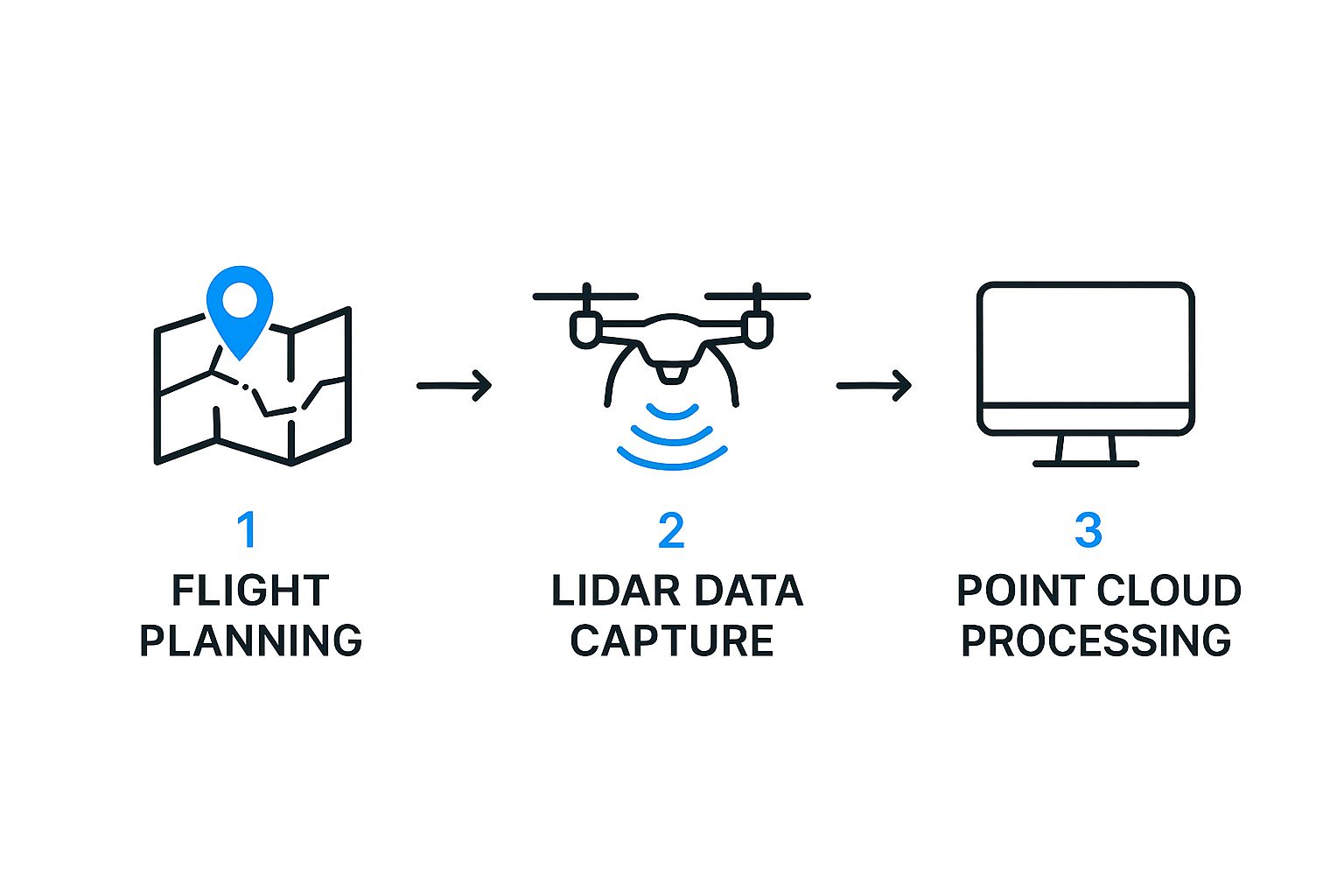
As you can see, successful drone LiDAR mapping is a structured workflow, not just a single flight. The quality of each step directly cascades down to affect the final point cloud's accuracy. Grasping this helps you appreciate just how critical each component is to the final result. If you're looking to go deeper into the hardware, you might find our guide on the top sensors for drones in 2025 to enhance your drone performance useful for exploring different options.
Choosing Your Drone LiDAR Hardware Setup
Getting started with drone LiDAR means making a critical decision right out of the gate: selecting your hardware. This isn't just about buying a drone and a sensor; it's about building a system. The choices you make here will define your efficiency in the field, the quality of your data, and ultimately, the success of your entire project.
Think of it like choosing the right tool for a construction job. You wouldn't use a framing hammer for delicate finish work, and you wouldn't use a tack hammer to build a house. The same principle applies here. There is no single "best" drone or sensor for every single job. The right choice is always tied to the mission's scale, complexity, and specific goals.
The Drone Platform: Multi-Rotor vs. Fixed-Wing
Your first big decision point is the type of drone you'll fly. The two main camps, multi-rotor and fixed-wing, each have distinct advantages, and understanding them is key to matching the aircraft to your projects.
Multi-Rotor Drones: These are what most people picture when they think of a drone—like a small helicopter with several propellers. Their biggest strength is agility. They can take off and land vertically (VTOL), hover perfectly still, and navigate tight, complex environments. This makes them perfect for detailed inspections, mapping small or obstructed job sites, or capturing every nook and cranny of a structure. The trade-off? Shorter flight times, which can limit their usefulness for really large-scale surveys.
Fixed-Wing Drones: Looking more like a traditional airplane, these drones are built for endurance and speed. A fixed-wing can cover huge areas—sometimes hundreds of acres—in a single flight. This makes them the clear winner for large topographical mapping projects, agricultural surveys, and long corridor mapping for things like pipelines or roads. Their main drawback is that they need open space for takeoff and landing, and they can't hover for those up-close, detailed inspections.
Selecting the Right LiDAR Sensor
Once you've settled on a drone platform, it's time to pick the sensor that will do the actual work. The spec sheets can look intimidating, but each technical term directly impacts the kind of data you can collect. Nailing this down is crucial.
A sensor's pulse rate and range are the two most important factors. They determine the density and reach of your data. A higher pulse rate gives you a richer, more detailed point cloud, which is vital for intricate models. A longer range lets you fly higher and cover more ground safely and efficiently.
When you're comparing sensors, keep an eye on these key metrics:
Pulse Rate (Points Per Second): This tells you how many laser pulses the sensor fires off every second. A higher pulse rate translates directly to a denser point cloud and more detailed 3D models.
Range: This is the maximum distance from which the sensor can get an accurate measurement. You'll need a longer range for high-altitude flights over big areas or terrain with a lot of elevation change.
Accuracy: This number, usually listed in centimeters, tells you the potential error in each measurement. For any kind of survey-grade work, high accuracy isn't just nice to have—it's non-negotiable.
Choosing the right equipment is a foundational skill. To build a setup that truly aligns with your projects and budget, you can dive deeper into our guide to master drone surveying and mapping with essential tips and techniques.
To help break it down, here’s a look at how these components fit together.
Drone LiDAR Hardware Considerations
Hardware Component | Key Considerations | Best For... |
|---|---|---|
Multi-Rotor Drone | VTOL capability, high maneuverability, shorter flight times. Excellent for hovering and navigating complex areas. | Detailed structural inspections, small construction sites, urban mapping, and projects requiring intricate data capture in a localized area. |
Fixed-Wing Drone | Long endurance and speed, requires open space for takeoff/landing. Can cover vast areas efficiently in a single flight. | Large-scale topographical mapping, agricultural surveys, corridor mapping (pipelines, roads), and environmental monitoring over large regions. |
LiDAR Sensor | Pulse rate, range, and accuracy are paramount. Weight and integration compatibility with the drone are also crucial. | High Pulse Rate: Intricate 3D models of structures. Long Range: High-altitude flights over large areas. High Accuracy: Survey-grade projects. |
GNSS/IMU System | The quality of the Inertial Measurement Unit (IMU) and Global Navigation Satellite System (GNSS) directly impacts data accuracy. | High-end systems are essential for any project requiring survey-grade precision and minimal reliance on ground control points. |
Ultimately, your goal is to build a cohesive kit where the drone, sensor, and positioning system all work together to meet the demands of your specific mapping jobs.
Your Drone LiDAR Mapping Workflow
Knowing the hardware inside a drone LiDAR system is one thing. Seeing how it all comes together on a real-world project is something else entirely. A successful mapping operation isn't just about the flight; it's a careful, step-by-step process that turns a mission plan into a genuinely valuable dataset.
This entire journey can be broken down into four distinct phases. Each stage builds on the one before it, making sure the final deliverables are accurate, reliable, and exactly what the project needs. Let’s walk through this workflow from start to finish.
Phase 1: Mission Planning
Long before the drone's propellers even twitch, the most important work has already started. The mission planning phase is the bedrock of the entire project, where you hammer out all the critical details. This is where you define the project's scope, figure out the required accuracy, and build a meticulous flight plan in specialized software.
During this stage, you'll lay out precise flight lines, lock in the flight altitude and speed, and decide on the overlap between each pass. Getting this right is how you guarantee the point density you need for a high-quality point cloud. Just as important, this is when you do your homework on airspace regulations, checking for any restrictions and getting the authorizations you need to fly legally and safely.
Phase 2: Data Acquisition
With a solid plan in your back pocket, it's time to head out to the field for data acquisition. This is the hands-on part where the drone finally takes to the sky to capture the raw LiDAR data. A smooth field operation is almost always the direct result of painstaking planning.
A key best practice here is setting up Ground Control Points (GCPs). These are just clearly marked spots on the ground with known, high-precision coordinates. Hitting these points with your LiDAR sensor lets you tie your digital model to the real world with incredible accuracy back in the office.
The quality of your data collection directly impacts every single step that follows. A well-flown mission with properly set ground control cuts down on errors and saves a ton of corrective work during processing.
Phase 3: Data Processing
Once the drone is back on the ground and the raw data is safely downloaded, the data processing phase kicks off. This is where the magic happens, turning millions of individual laser returns into a clean, classified, and usable point cloud. It’s a step that demands both powerful software and a skilled hand.
First, the raw data from the GNSS, IMU, and LiDAR sensor are fused together to generate an initial point cloud. The next critical step is classification, where software algorithms—either automatically or with some human guidance—sort every single point into categories.
Common classifications include:
Ground: Identifying the bare earth surface.
Vegetation: Separating out trees, bushes, and other plants.
Buildings: Isolating houses, sheds, and other man-made structures.
Noise: Filtering out bad data points, like a bird flying through the scan.
This intelligent sorting is what lets you do cool things like create a bare-earth terrain model by simply turning off all the other classifications.
Phase 4: Analysis and Deliverables
This final phase is where all that hard work gets turned into something tangible for the client. We call this analysis and deliverables. The specific products depend entirely on what the project calls for, but they all spring from the rich 3D data you’ve created.
For example, a civil engineering firm might need a Digital Elevation Model (DEM) and detailed contour lines for site planning. A construction company might ask for volumetric calculations to measure how much material is in their stockpiles. An environmental agency could use the data for a 3D visualization to monitor coastal erosion over time. This is the step that turns precise data into powerful decisions.
Real-World Applications of Drone LiDAR
This is where the rubber meets the road. All the theory behind drone LiDAR mapping comes alive when you see how it solves real problems, saving time, money, and boosting safety across a surprising range of industries. Its applications are as diverse as they are powerful, from busy construction sites to remote, dense forests.
Think about a massive earthworks project. Instead of spending days or weeks on slow, manual ground surveys, a drone takes flight. In just one afternoon, it captures a complete, high-density point cloud of the entire site. That data lets the team calculate cut-and-fill volumes with incredible accuracy, track progress daily, and keep the project perfectly on schedule and budget.
From Forests to Power Lines
But drone LiDAR’s versatility doesn’t stop at construction. Its ability to pierce through vegetation is a game-changer for forestry management. A drone can fly over a huge tract of land and literally "see" through the tree canopy to the ground below. This allows forestry companies to accurately measure timber volume, check on tree health, and build precise digital elevation models for smarter, sustainable logging.
Environmental teams use this same superpower to monitor and manage natural resources. Imagine trying to track coastal erosion. Regular LiDAR scans give an exact measurement of how the shoreline is changing over time, helping engineers design effective protection strategies to protect communities and vital habitats.
Other key uses are popping up everywhere:
Infrastructure Inspection: You can safely inspect miles of power lines and transmission towers, spotting hazards like encroaching trees without sending a single crew member into a dangerous situation.
Archaeological Discovery: LiDAR helps uncover ancient ruins and settlements that have been hidden for centuries under dense jungle canopies, revealing historical sites that were completely invisible before.
Mining Operations: Teams can calculate stockpile volumes with extreme precision for better inventory management and monitor slope stability to prevent catastrophic landslides.
These practical examples all point to one core truth: drone LiDAR gives professionals a new depth of insight. By delivering extraordinarily detailed 3D data from tough environments, it empowers them to make smarter, faster, and safer decisions.
A Rapidly Growing Market
This long and growing list of applications is fueling some serious market expansion. Demand for drone LiDAR mapping is surging in land surveying, construction, and environmental monitoring. The market for LiDAR drones is projected to hit USD 1.9 billion by 2032, climbing at a compound annual growth rate of 17.6%.
That kind of growth shows the clear return on investment companies are getting. Each use case demonstrates the practical power of creating a detailed digital twin of the physical world. This is the heart of why so many different sectors are adopting the technology.
To see how this data gets visualized, you might be interested in our guide on how drone 3D mapping can revolutionize industries with aerial tech. Ultimately, these real-world uses show exactly what becomes possible when you pair advanced aerial platforms with powerful laser scanning.
Answering Your Drone LiDAR Questions
As drone LiDAR mapping moves from a niche technology to a mainstream tool, it’s only natural that questions—and a few myths—start to surface. Getting to the bottom of what this tech can and can't do is the first step in figuring out if it’s the right solution for your projects.
So, let's clear the air and tackle some of the most common questions head-on.
One of the first things people ask is how drone LiDAR stacks up against photogrammetry. While both can create stunning 3D models, they are fundamentally different tools built for very different jobs. I like to think of it this way: LiDAR gives you X-ray vision, while photogrammetry is like taking a series of incredibly detailed photographs.
LiDAR vs. Photogrammetry: Which Is Better?
There's no single "better" option—it all comes down to what you need to accomplish.
LiDAR is an active sensor. It doesn't rely on sunlight; instead, it shoots out its own laser pulses and meticulously measures how they bounce back. This allows it to slice right through dense vegetation and capture the true ground surface hidden beneath. It’s the undisputed champion for any project demanding high vertical accuracy, especially in forested terrain. And since it brings its own light to the party, it works just as well at dusk as it does at high noon.
Photogrammetry, on the other hand, is a passive system. It uses a high-resolution camera to snap hundreds or thousands of overlapping photos, which are then stitched together with sophisticated software to build a 3D model. This approach is more budget-friendly and shines when you need visually rich, full-color models of open areas, buildings, or landscapes where ground-obscuring vegetation isn't an issue.
Making the right choice is all about the project's goals:
Go with LiDAR when you need survey-grade terrain models under a thick tree canopy or when precise elevation data is the top priority.
Go with Photogrammetry when your main goal is creating photorealistic, colorized 3D models of structures and open terrain where visual detail is key.
Key Challenges and Considerations
For all its power, drone LiDAR isn't a magic wand. There are a few practical hurdles to be aware of, especially for teams just getting started. The biggest ones usually boil down to cost, complexity, and some operational limits.
LiDAR systems are a serious investment, carrying a much higher price tag than the standard camera payloads used for photogrammetry.
Beyond the hardware, the data itself is more demanding. You're dealing with enormous point cloud datasets that require powerful software and the technical know-how to classify points and turn them into something useful. Operationally, LiDAR can also struggle in bad weather. Heavy rain, dense fog, or snow can interfere with the laser pulses, throwing off the accuracy of your data.
One of drone LiDAR's greatest strengths is its incredible accuracy, often reaching survey-grade results of 2 to 5 centimeters. This precision isn't a given, though. It's a direct result of the sensor quality, the flight planning, and the skill used during data processing.
Understanding Your Final Deliverables
So, after the drone has landed and the data is processed, what do you actually get? The primary output from any drone LiDAR survey is the georeferenced point cloud. This is a massive file (typically in .LAS or .LAZ format) that contains millions of individual points, each with its own precise X, Y, and Z coordinate.
This raw data is the foundation from which all other valuable products are built.
Common deliverables you can expect include:
Digital Elevation Models (DEMs): These show the bare-earth terrain, with all trees, buildings, and other surface features digitally removed.
Digital Surface Models (DSMs): These models capture the top surfaces of everything, including treetops and rooftops.
High-Resolution Contour Maps: Essential for topographical analysis and site planning.
3D Mesh Models: Great for creating immersive visualizations and virtual fly-throughs.
These products are incredibly versatile, finding uses in countless industries, from construction and forestry to environmental monitoring. The core idea of using aerial data to make smarter decisions is even transforming other fields; you can see how drones are redefining modern agriculture in one of our related guides. Understanding these final deliverables is key to communicating your project needs and ensuring you walk away with the right data for the job.
Ready to dive deeper into the world of aerial innovation? At JAB Drone, we provide the expert reviews, in-depth guides, and breaking news you need to stay ahead. Explore our resources and join a community passionate about drone technology by visiting us at https://www.jabdrone.com.
Comments